File:Map of areas affected by 2021 European floods.svg
Przejdź do nawigacji
Przejdź do wyszukiwania

Wielkość pliku podglądu PNG dla pliku SVG: 587 × 600 pikseli Inne rozdzielczości: 235 × 240 pikseli | 470 × 480 pikseli | 752 × 768 pikseli | 1002 × 1024 pikseli | 2004 × 2048 pikseli | 593 × 606 pikseli.
Rozmiar pierwotny (Plik SVG, nominalnie 593 × 606 pikseli, rozmiar pliku: 695 KB)
Podpisy
Podpisy
Dodaj jednolinijkowe objaśnienie tego, co ten plik pokazuje
Opis
[edytuj]
| Opis |
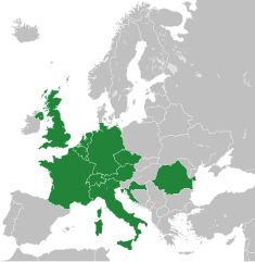
English: A map of the areas affected by the 2021 European Floods, derived from Blank map of Europe cropped.svg.
(Green) 2021 European floods.
(Gray) Europe.
(Light-gray) The surrounding region.
|
| Data | |
| Źródło | Praca własna |
| Autor | Isochrone |
| Inne wersje |
Ten obraz wektorowy zawiera elementy, które zostały zaczerpnięte lub zaadaptowane z tego pliku: |
| SVG rozwój |
Licencja
[edytuj]
Ja, właściciel praw autorskich do tego dzieła, udostępniam je na poniższej licencji
This file is licensed under the Creative Commons Attribution-Share Alike Attribution-Share Alike 4.0 International, 3.0 Unported, 2.5 Generic, 2.0 Generic and 1.0 Generic license.
- Wolno:
- dzielić się – kopiować, rozpowszechniać, odtwarzać i wykonywać utwór
- modyfikować – tworzyć utwory zależne
- Na następujących warunkach:
- uznanie autorstwa – musisz określić autorstwo utworu, podać link do licencji, a także wskazać czy utwór został zmieniony. Możesz to zrobić w każdy rozsądny sposób, o ile nie będzie to sugerować, że licencjodawca popiera Ciebie lub Twoje użycie utworu.
- na tych samych warunkach – Jeśli zmienia się lub przekształca niniejszy utwór, lub tworzy inny na jego podstawie, można rozpowszechniać powstały w ten sposób nowy utwór tylko na podstawie tej samej lub podobnej licencji.
Historia pliku
Kliknij na odpowiedniej dacie/czasie, aby zobaczyć wersję pliku z tamtego okresu.
| Data/czas | Miniatura | Wymiary | Użytkownik | Opis | |
|---|---|---|---|---|---|
| aktualny | 10:01, 27 gru 2022 | | 593 × 606 (695 KB) | Iktsokh (dyskusja | edycje) | Correction of borders |
| 08:57, 22 lip 2021 |  | 593 × 606 (692 KB) | Isochrone (dyskusja | edycje) | update | |
| 14:12, 18 lip 2021 |  | 593 × 606 (698 KB) | GPinkerton (dyskusja | edycje) | Re-add France because there were also floods in France ([https://en.wikipedia.org/w/index.php?title=2021_European_floods&oldid=1034207380#France]). A more useful map would be by regions, there's no reason Sardinia, most of Great Britain, Northern Ireland, etc need to be here ... | |
| 09:44, 18 lip 2021 |  | 593 × 606 (692 KB) | Jurryaany (dyskusja | edycje) | Added Austria | |
| 18:28, 17 lip 2021 |  | 593 × 606 (692 KB) | Isochrone (dyskusja | edycje) | rm france | |
| 13:47, 17 lip 2021 |  | 593 × 606 (692 KB) | Isochrone (dyskusja | edycje) | better colour | |
| 13:40, 17 lip 2021 |  | 593 × 606 (692 KB) | Isochrone (dyskusja | edycje) | Uploaded own work with UploadWizard |
Nie możesz nadpisać tego pliku.
Lokalne wykorzystanie pliku
Żadna strona nie korzysta z tego pliku.
Globalne wykorzystanie pliku
Ten plik jest wykorzystywany także w innych projektach wiki:
- Wykorzystanie na fr.wikipedia.org
- Wykorzystanie na ja.wikipedia.org
- Wykorzystanie na ne.wikipedia.org
- Wykorzystanie na pl.wikipedia.org
- Wykorzystanie na pt.wikipedia.org
- Wykorzystanie na ro.wikipedia.org
- Wykorzystanie na simple.wikipedia.org
- Wykorzystanie na tr.wikipedia.org