File:Map of federal subjects of Russia (2022), disputed Crimea and Donbass.svg
跳转到导航
跳转到搜索

此SVG文件的PNG预览的大小:512 × 282像素。 其他分辨率:320 × 176像素 | 640 × 353像素 | 1,024 × 564像素 | 1,280 × 705像素 | 2,560 × 1,410像素。
原始文件 (SVG文件,尺寸为512 × 282像素,文件大小:827 KB)
说明
说明
添加一行文字以描述该文件所表现的内容
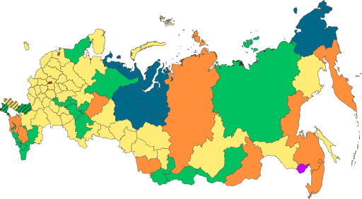
Primary administrative divisions of Russia, colored (and shaded) by type

|
The boundaries on this map show the de facto situation. This is just one of several different views on the subject (see COM:NPOV). |
摘要[编辑]
,_disputed_Crimea_and_Donbass.svg&action=edit§ion=1)
| 描述 |
English: Copy of File:Map of federal subjects of Russia (2022).svg with disputed annexed Ukrainian territories indicated with diagonal stripes |
| 日期 | |
| 来源 |
本文件衍生自: Map of federal subjects of Russia 2014, disputed Crimea.svg |
| 作者 | Mzajac, Ltbubbas |
.svg)
许可协议[编辑]
,_disputed_Crimea_and_Donbass.svg&action=edit§ion=2)
| 此地图不符合版权的资格,因此属于公有领域,因为其完全包含公共财产信息,不包含原作者身份。详情参见Commons:Threshold of originality § Maps。
|
文件历史
点击某个日期/时间查看对应时刻的文件。
| 日期/时间 | 缩略图 | 大小 | 用户 | 备注 | |
|---|---|---|---|---|---|
| 当前 | 2022年10月4日 (二) 19:48 | | 512 × 282(827 KB) | Techso01(留言 | 贡献) | Uploaded a work by Mzajac, Ltbubbas from {{derived from|Map of federal subjects of Russia (2014), disputed Crimea.svg}} with UploadWizard |
您不可以覆盖此文件。
文件用途
没有页面使用本文件。
全域文件用途
以下其他wiki使用此文件:
- ab.wikipedia.org上的用途
- ar.wikipedia.org上的用途
- ast.wikipedia.org上的用途
- be.wikipedia.org上的用途
- cs.wikipedia.org上的用途
- de.wikipedia.org上的用途
- en.wikipedia.org上的用途
- es.wikipedia.org上的用途
- fa.wikipedia.org上的用途
- fr.wikipedia.org上的用途
- is.wikipedia.org上的用途
- it.wikipedia.org上的用途
- ja.wikipedia.org上的用途
- ko.wikipedia.org上的用途
- la.wikipedia.org上的用途
- lez.wikipedia.org上的用途
- lld.wikipedia.org上的用途
- lt.wikipedia.org上的用途
- lv.wikipedia.org上的用途
- mi.wikipedia.org上的用途
- oc.wikipedia.org上的用途
- pt.wikipedia.org上的用途
- ru.wikipedia.org上的用途
- sl.wikipedia.org上的用途
- sr.wikipedia.org上的用途
- th.wikipedia.org上的用途
- tly.wikipedia.org上的用途
- tum.wikipedia.org上的用途
- uk.wikipedia.org上的用途
- uz.wikipedia.org上的用途
- vi.wikipedia.org上的用途
- vls.wikipedia.org上的用途
查看本文件的更多全域用途。
,_disputed_Crimea_and_Donbass.svg)
,_disputed_Crimea_and_Donbass.svg&oldid=874970177)