File:Map of language areas of Xinjiang.png
跳至導覽
跳至搜尋
預覽大小:800 × 448 像素。 其他解析度:320 × 179 像素 | 640 × 358 像素 | 1,188 × 665 像素。
原始檔案 (1,188 × 665 像素,檔案大小:844 KB,MIME 類型:image/png)
說明
說明
添加單行說明來描述出檔案所代表的內容

|
本圖片是以PNG、GIF或JPEG格式上傳。然而,其中包含的資料或訊息,應該重新建立成可縮放向量圖形(SVG)檔案,以更有效率或更準確的方式儲存。如有可能,請上傳本圖片的SVG格式版本。在上傳之後,請修改維基各姊妹計畫中所有使用舊版圖片的條目(列在圖像連結章節中),替換為新版圖片,並在舊圖片的描述頁中加入{{Vector version available|新圖片名稱.svg}}模板,同時移除本模板。
|
摘要
[編輯]
| 描述 |
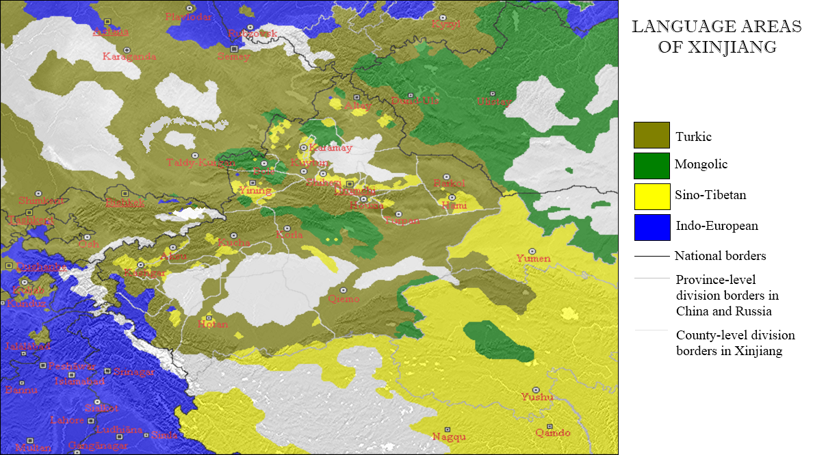
English: This map shows the distribution of the largest primary demonstrated language families in the Xinjiang region of China, as well as of the surrounding states and regions. |
| 日期 | 2006年十月23日, 08:04 (原始上傳日期). |
| 來源 | 自己的作品, based on [1]. |
| 作者 | Postmann Michael (Michael Postmann). |
授權條款
[編輯]
我,本作品的著作權持有者,決定用以下授權條款發佈本作品:

|
已授權您依據自由軟體基金會發行的無固定段落、封面文字和封底文字GNU自由文件授權條款1.2版或任意後續版本,對本檔進行複製、傳播和/或修改。該協議的副本列在GNU自由文件授權條款中。 |
| 此檔案採用共享創意 姓名標示-相同方式分享 3.0 未在地化版本授權條款。 | ||
| ||
| 已新增授權條款標題至此檔案,作為GFDL授權更新的一部份。 |
此檔案採用創用CC 姓名標示 2.5 通用版授權條款。
- 您可以自由:
- 分享 – 複製、發佈和傳播本作品
- 重新修改 – 創作演繹作品
- 惟需遵照下列條件:
- 姓名標示 – 您必須指名出正確的製作者,和提供授權條款的連結,以及表示是否有對內容上做出變更。您可以用任何合理的方式來行動,但不得以任何方式表明授權條款是對您許可或是由您所使用。
您可以選擇您需要的授權條款。
| 此作品已由其作者,Postmann Michael,釋出至公有領域。此授權條款在全世界均適用。 這可能在某些國家不合法,如果是的話: |
檔案歷史
點選日期/時間以檢視該時間的檔案版本。
| 日期/時間 | 縮圖 | 尺寸 | 用戶 | 備註 | |
|---|---|---|---|---|---|
| 目前 | 2011年11月23日 (三) 23:36 | | 1,188 × 665(844 KB) | Quigley(對話 | 貢獻) | Better grammar and correct names in legend |
| 2006年10月23日 (一) 00:04 |  | 1,188 × 665(839 KB) | Postmann Michael~commonswiki(對話 | 貢獻) | new vision | |
| 2006年10月22日 (日) 21:49 |  | 966 × 576(69 KB) | Postmann Michael~commonswiki(對話 | 貢獻) | This map shows the language areas of the largest peoples in the Chinese part of the old Turkistan (so-called "East-Turkistan" and/or "Chinese Turkistan") with the adjacent states. This map is based on the map of http://www.hunmagyar.org/tf-tn/uygur/eturk |
無法覆蓋此檔案。
檔案用途
下列5個頁面有用到此檔案:
全域檔案使用狀況
以下其他 wiki 使用了這個檔案:
- af.wikipedia.org 的使用狀況
- azb.wikipedia.org 的使用狀況
- ca.wikipedia.org 的使用狀況
- cs.wikipedia.org 的使用狀況
- en.wikipedia.org 的使用狀況
- es.wikipedia.org 的使用狀況
- fa.wikipedia.org 的使用狀況
- fi.wikipedia.org 的使用狀況
- fr.wikipedia.org 的使用狀況
- incubator.wikimedia.org 的使用狀況
- lez.wikipedia.org 的使用狀況
- lv.wikipedia.org 的使用狀況
- mk.wikipedia.org 的使用狀況
- mn.wikipedia.org 的使用狀況
- ms.wikipedia.org 的使用狀況
- pnb.wikipedia.org 的使用狀況
- pt.wikipedia.org 的使用狀況
- ru.wikipedia.org 的使用狀況
- sk.wikipedia.org 的使用狀況
- tr.wikipedia.org 的使用狀況
- ug.wikipedia.org 的使用狀況
- uk.wikipedia.org 的使用狀況
- uz.wikipedia.org 的使用狀況
- wuu.wikipedia.org 的使用狀況
- zh.wikipedia.org 的使用狀況