File:Map of the Imperial Circles (1512)-de.png
ナビゲーションに移動
検索に移動

このプレビューのサイズ: 610 × 599 ピクセル。 その他の解像度: 244 × 240 ピクセル | 489 × 480 ピクセル | 727 × 714 ピクセル。
元のファイル (727 × 714 ピクセル、ファイルサイズ: 67キロバイト、MIME タイプ: image/png)
キャプション
キャプション
このファイルの内容を1行で記述してください
| 解説 |
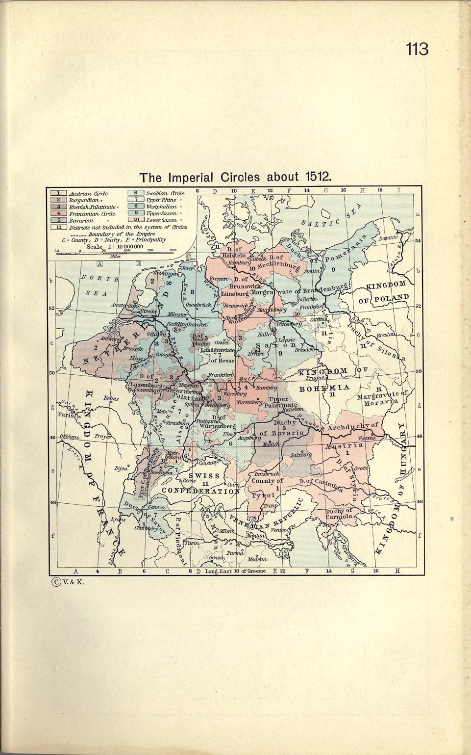
English: Map of the Imperial Circles (1512)-de. |
| 原典 |
|
| 作者 | I am the author of this image file. |
| その他のバージョン |
[] 1512[編集]
1560[編集]
|
-bg.png)
-ca.svg&lang=ca)
-de.png)
-en.png)
-es.svg)
-fr.svg)
.png)
-ca.svg&lang=ca)
-de.svg)
-en.svg)
-es.svg)
-la.svg)
-nl.svg)
![[1]](https://maps.lib.utexas.edu/maps/historical/shepherd/imperial_circles_1512.jpg)
このファイルはクリエイティブ・コモンズ 表示-継承 2.0 ドイツライセンスのもとに利用を許諾されています。
- あなたは以下の条件に従う場合に限り、自由に
- 共有 – 本作品を複製、頒布、展示、実演できます。
- 再構成 – 二次的著作物を作成できます。
- あなたの従うべき条件は以下の通りです。
- 表示 – あなたは適切なクレジットを表示し、ライセンスへのリンクを提供し、変更があったらその旨を示さなければなりません。これらは合理的であればどのような方法で行っても構いませんが、許諾者があなたやあなたの利用行為を支持していると示唆するような方法は除きます。
- 継承 – もしあなたがこの作品をリミックスしたり、改変したり、加工した場合には、あなたはあなたの貢献部分を元の作品とこれと同一または互換性があるライセンスの下に頒布しなければなりません。

ファイルの履歴
過去の版のファイルを表示するには、その版の日時をクリックしてください。
| 日付と時刻 | サムネイル | 寸法 | 利用者 | コメント | |
|---|---|---|---|---|---|
| 現在の版 | 2005年10月30日 (日) 16:31 | | 727 × 714 (67キロバイト) | Finanzer (トーク | 投稿記録) | *I am the author of this image file. *Its contents are based in part on a map published in the "Historical Atlas" by Prof. William R Shepherd, pub. Henry Holt & Co. (New York, 1911). *first uploaded to de-WP: 14:50, 15. Okt 200 |
このファイルは上書きできません。
ファイルの使用状況
以下の 19 ページがこのファイルを使用しています:
- Atlas of Austria
- Maps of Austria
- File:Imperial Circles-2005-10-15-de.png (リダイレクト)
- File:Map of the Imperial Circles (1512)-bg.png
- File:Map of the Imperial Circles (1512)-ca.svg
- File:Map of the Imperial Circles (1512)-de.png
- File:Map of the Imperial Circles (1512)-en.png
- File:Map of the Imperial Circles (1512)-es.svg
- File:Map of the Imperial Circles (1512)-fr.svg
- File:Map of the Imperial Circles (1560)-ca.svg
- File:Map of the Imperial Circles (1560)-de.svg
- File:Map of the Imperial Circles (1560)-en.svg
- File:Map of the Imperial Circles (1560)-es.svg
- File:Map of the Imperial Circles (1560)-la.svg
- File:Map of the Imperial Circles (1560)-nl.svg
- File:Német-római Birodalom körzetei (1512).png
- Template:Other versions/Map of the Imperial Circles
-ca.svg)
-ca.svg)
グローバルなファイル使用状況
以下に挙げる他のウィキがこの画像を使っています:
- af.wikipedia.org での使用状況
- azb.wikipedia.org での使用状況
- da.wikipedia.org での使用状況
- de.wikipedia.org での使用状況
- Heiliges Römisches Reich
- Niedersachsen
- 1512
- Geschichte Kärntens
- Reichstage zu Augsburg
- Geschichte Luxemburgs
- Krain
- Vorderösterreich
- Erste Wiener Türkenbelagerung
- Tarasp
- Geschichte der Steiermark
- Grafschaft Schaunberg
- Bistum Chur
- Deutschordensballei An der Etsch und im Gebirge
- Görz und Gradisca
- Diözese Bozen-Brixen
- Reichsreform (Heiliges Römisches Reich)
- Österreichischer Reichskreis
- Diskussion:Balkanhalbinsel/Archiv
- Geschichte Niederösterreichs
- Diskussion:Schwäbischer Reichskreis
- Erzbistum Trient
- Herzogtum Salzburg
- Gefürstete Grafschaft Tirol
- Markgrafschaft Istrien
- Geschichte Oberösterreichs
- Luxemburg
- Burgundischer Vertrag
- Guestphalia
- Erzherzogtum Österreich
- Nicht eingekreiste zum Heiligen Römischen Reich zugehörige Territorien und Stände
- Vorlage:Navigationsleiste Österreichischer Reichskreis
- Ballei Österreich des Deutschen Ordens
- Reichsunmittelbare Stadt Triest und ihr Gebiet
- Benutzer:Daniel L.F./Vertonung/Heiliges Römisches Reich
- Musikjahr 1580
- Musikjahr 1587
- Herrschaft Tarasp
- Wikipedia:WikiProjekt Österreich/checks/Navis/Österreich
- eo.wikipedia.org での使用状況
- fy.wikipedia.org での使用状況
- gv.wikipedia.org での使用状況
- hu.wikipedia.org での使用状況
このファイルのグローバル使用状況を表示する。
-de.png)
-de.png&oldid=833173999)