File:Map of the Territory of the Brigantes.svg
Aller à la navigation
Aller à la recherche

Taille de cet aperçu PNG pour ce fichier SVG : 424 × 600 pixels. Autres résolutions : 170 × 240 pixels | 339 × 480 pixels | 543 × 768 pixels | 724 × 1 024 pixels | 1 448 × 2 048 pixels | 744 × 1 052 pixels.
Fichier d’origine (Fichier SVG, nominalement de 744 × 1 052 pixels, taille : 149 kio)
Légendes
Légendes
Ajoutez en une ligne la description de ce que représente ce fichier
| Description |
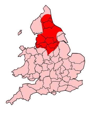
English: County map of England & Wales, overlaid with Territory of the Romano-British Brigantes Tribe of Northern England. |
| Date | (UTC) |
| Source | |
| Auteur |
|
| Autorisation (Réutilisation de ce fichier) |
Moi, en tant que détenteur des droits d’auteur sur cette œuvre, je la publie sous la licence suivante : Ce fichier est disponible selon les termes de la licence Creative Commons Attribution – Partage dans les Mêmes Conditions 3.0 (non transposée).
|
| Autres versions | Œuvres dérivées de ce fichier : Map of the Territory of the Carvetii.svg |
| Cette image a été retouchée, ce qui signifie qu'elle a été modifiée par ordinateur et est différente de l'image d'origine. Liste des modifications : Revised to show territory of the Brigantes. L'image d'origine se trouve ici : England Celtic tribes - North and Midlands.png:
|
Journal des téléversements d’origine[modifier]
This image is a derivative work of the following images:
- File:England_Celtic_tribes_-_North_and_Midlands.png licensed with Cc-by-sa-3.0
- 2009-07-29T23:43:34Z Thomas Gun 296x495 (27459 Bytes) == Summary == {{Information |Description=Image depicting the Celts of North and Midland England, pre-[[Roman Britain]] times. I created this myself, under the guidance (to find location of them) of [http://www.roman-britain.o
Téléversé avec derivativeFX
Historique du fichier
Cliquer sur une date et heure pour voir le fichier tel qu'il était à ce moment-là.
| Date et heure | Vignette | Dimensions | Utilisateur | Commentaire | |
|---|---|---|---|---|---|
| actuel | 16 octobre 2009 à 20:25 | | 744 × 1 052 (149 kio) | Jpb1301 (d | contributions) | {{Information |Description=County map of England & Wales, overlaid with Territory of the Romano-British Brigantes Tribe of Northern England. |Source=*File:England_Celtic_tribes_-_North_and_Midlands.png |Date=2009-10-16 20:19 (UTC) |Author=*[[:File:E |
Vous ne pouvez pas remplacer ce fichier.
Utilisations locales du fichier
La page suivante utilise ce fichier :
Utilisations du fichier sur d’autres wikis
Les autres wikis suivants utilisent ce fichier :
- Utilisation sur bg.wikipedia.org
- Utilisation sur br.wikipedia.org
- Utilisation sur ca.wikipedia.org
- Utilisation sur cy.wikipedia.org
- Utilisation sur de.wikipedia.org
- Utilisation sur en.wikipedia.org
- Utilisation sur es.wikipedia.org
- Utilisation sur eu.wikipedia.org
- Utilisation sur fi.wikipedia.org
- Utilisation sur fr.wikipedia.org
- Utilisation sur fy.wikipedia.org
- Utilisation sur id.wikipedia.org
- Utilisation sur ka.wikipedia.org
- Utilisation sur ko.wikipedia.org
- Utilisation sur la.wikipedia.org
- Utilisation sur nds.wikipedia.org
- Utilisation sur nl.wikipedia.org
- Utilisation sur nn.wikipedia.org
- Utilisation sur no.wikipedia.org
- Utilisation sur ru.wikipedia.org
- Utilisation sur sh.wikipedia.org
- Utilisation sur simple.wikipedia.org
- Utilisation sur sr.wikipedia.org
- Utilisation sur xmf.wikipedia.org