File:Maps of the Armenian Empire of Tigranes.gif
Skočit na navigaci
Skočit na vyhledávání
Velikost tohoto náhledu: 603 × 599 pixelů. Jiná rozlišení: 241 × 240 pixelů | 483 × 480 pixelů | 673 × 669 pixelů.
Původní soubor (673 × 669 pixelů, velikost souboru: 56 KB, MIME typ: image/gif)
Popisky
Popisky
Přidejte jednořádkové vysvětlení, co tento soubor představuje

|
Tento obrázek (skupina map) by měl být vytvořen pomocí vektorové grafiky jako SVG soubor. To má několik výhod; podrobnosti najdete na stránce Commons:Media for cleanup. Je-li SVG verze tohoto obrázku již k dispozici, prosím nahrajte ji. Po nahrání nahraďte tuto šablonu šablonou {{Vector version available|jméno nového obrázku.svg}}.
|
Popis[editovat]
| Popis |
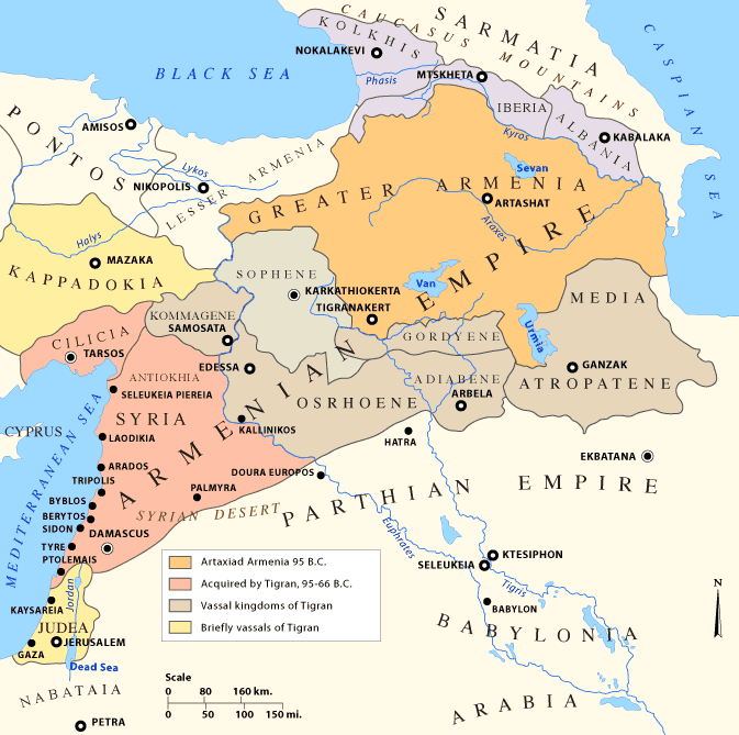
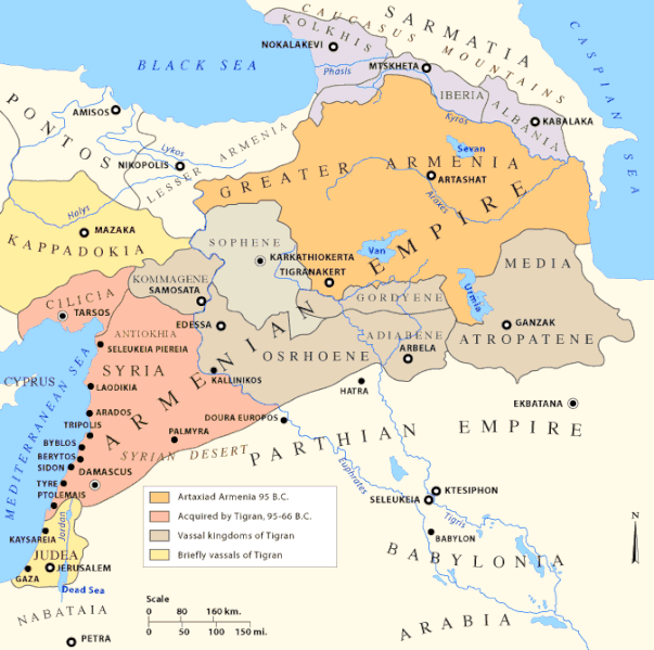
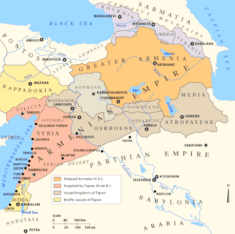
English: Early Armenian Empire of Tigranes, which existed between the final collapse of the Seleucids and the Roman conquest of the eastern Mediterranean. Original text: The Empire of Tigran the Great, 95-66 BC |
| Datum |
Uploaded to en.wikipedia on 11. ledna 2007, 20:24
|
| Zdroj |
|
| Autor | Uploaded to en.wikipedia by en:user:Nareklm |
| Další verze |
[]
|
.svg)


Licence[editovat]

|
Tento dokument smí být kopírován, šířen nebo upravován podle podmínek Svobodné licence GNU pro dokumenty verze 1.2 nebo libovolné vyšší verze publikované nadací Free Software Foundation. Dokument nemá neměnné části ani texty na předním či zadním přebalu. Kopie textu licence je k dispozici v oddíle nazvaném GNU Free Documentation License. |
| Tento soubor podléhá licenci Creative Commons Uveďte autora-Zachovejte licenci 3.0 Unported | ||
| ||
| Tato licenční šablona byla k tomuto souboru přidána v rámci změny licencování. |
This permission only applies to images existing on http://armenica.org/ as of 1 January 2007. Any later images do not fall under this permission!
Historie souboru
Kliknutím na datum a čas se zobrazí tehdejší verze souboru.
| Datum a čas | Náhled | Rozměry | Uživatel | Komentář | |
|---|---|---|---|---|---|
| současná | 18. 12. 2017, 14:23 | | 673 × 669 (56 KB) | Maproom (diskuse | příspěvky) | changed "LESSER A ARMENIA" to "LESSER ARMENIA" |
| 28. 3. 2010, 16:59 |  | 673 × 669 (56 KB) | Ras67 (diskuse | příspěvky) | cropped, watermark removed | |
| 13. 1. 2007, 04:02 |  | 700 × 711 (61 KB) | TigranMets (diskuse | příspěvky) | The Armenian Empire... Please see: http://en.wikipedia.org/wiki/Image:20tigranes95-66.gif |
Tento soubor nemůžete přepsat.
Využití souboru
Na Commons na soubor odkazují tyto stránky:
- Atlas of Abkhazia
- Atlas of Adjara
- Atlas of Armenia
- Atlas of Artsakh
- Atlas of Azerbaijan
- Atlas of Georgia
- Atlas of Kurdistan
- Top 200 map images that should use vector graphics
- User:Geagea/Israel/2017 December 18
- File:20tigranes95-66.gif (přesměrování)
- File:Armenia Minor map first century BC.jpg
- File:Great Armenia.png (přesměrování)
- File:Map of the Armenian Empire of Tigranes (English).svg
- File:Maps of the Armenian Empire of Tigranes-es.svg
- File:Maps of the Armenian Empire of Tigranes-fr.svg
- File:Maps of the Armenian Empire of Tigranes-he.svg
- File:Maps of the Armenian Empire of Tigranes-pt.svg
- File:Maps of the Armenian Empire of Tigranes-ru.svg
- File:Maps of the Armenian Empire of Tigranes.gif
- Template:Other versions/Maps of the Armenian Empire of Tigranes
Globální využití souboru
Tento soubor využívají následující wiki:
- Využití na af.wikipedia.org
- Využití na arc.wikipedia.org
- Využití na ar.wikipedia.org
- Využití na arz.wikipedia.org
- Využití na azb.wikipedia.org
- Využití na az.wikipedia.org
- Využití na ba.wikipedia.org
- Využití na be-tarask.wikipedia.org
- Využití na be.wikipedia.org
- Využití na bg.wikipedia.org
- Využití na br.wikipedia.org
- Využití na bs.wikipedia.org
Zobrazit další globální využití tohoto souboru.
Kategorie:
- Georgia in the 1st century BC
- Maps of Adiabene
- Maps of Cappadocia
- Maps of Caucasian Albania
- Maps of Colchis
- Maps of Commagene
- Maps of Corduene
- Maps of Osrhoene
- Maps of Parthia
- Maps of Sarmatia
- Maps of Sophene
- Maps of ancient Armenia
- Maps of the Kingdom of Iberia
- Maps of the Middle East
- Maps of the history of Armenia
- Maps of the history of Azerbaijan
- Maps of the history of Georgia
- Maps of the history of Iraq
- Maps of the history of Israel
- Maps of the history of Syria
- Maps of the history of Turkey
- Maps of the history of the Caucasus in antiquity
- Maps showing 1st-century BC history