File:Maps of the Armenian Empire of Tigranes.gif
Zur Navigation springen
Zur Suche springen
Größe dieser Vorschau: 603 × 599 Pixel. Weitere Auflösungen: 241 × 240 Pixel | 483 × 480 Pixel | 673 × 669 Pixel.
Originaldatei (673 × 669 Pixel, Dateigröße: 56 KB, MIME-Typ: image/gif)
Bildtexte
Kurzbeschreibungen
Ergänze eine einzeilige Erklärung, was diese Datei darstellt.

|
Dieses Bild des Typs Map sollte als Vektorgrafik im SVG-Format neu erstellt werden. Vektorformate haben zahlreiche Vorteile; weitere Information unter Commons:Media for cleanup. Wenn dir eine SVG-Version dieses Bildes vorliegt, so lade diese bitte hoch. Nach dem Hochladen der Datei ist diese Vorlage auf der aktuellen Bildbeschreibungsseite durch die Vorlage {{Vector version available}}, oder kürzer {{Vva}}, zu ersetzen. Es ist empfohlen die neue SVG-Datei „Maps of the Armenian Empire of Tigranes.svg“ zu nennen – dann benötigt die Vorlage vector version available (bzw. vva) keinen Parameter.
|
Beschreibung
[Bearbeiten]| Beschreibung |
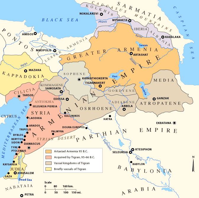
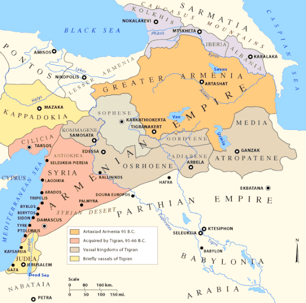
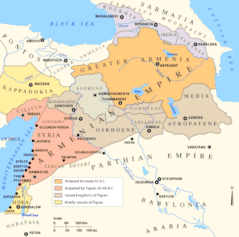
English: Early Armenian Empire of Tigranes, which existed between the final collapse of the Seleucids and the Roman conquest of the eastern Mediterranean. Original text: The Empire of Tigran the Great, 95-66 BC |
| Datum |
Uploaded to en.wikipedia on 11. Januar 2007, 20:24
|
| Quelle |
|
| Urheber | Uploaded to en.wikipedia by en:user:Nareklm |
| Andere Versionen |
[]
|
.svg)


Lizenz
[Bearbeiten]

|
Es ist erlaubt, die Datei unter den Bedingungen der GNU-Lizenz für freie Dokumentation, Version 1.2 oder einer späteren Version, veröffentlicht von der Free Software Foundation, zu kopieren, zu verbreiten und/oder zu modifizieren; es gibt keine unveränderlichen Abschnitte, keinen vorderen und keinen hinteren Umschlagtext.
Der vollständige Text der Lizenz ist im Kapitel GNU-Lizenz für freie Dokumentation verfügbar. |
| Diese Datei ist unter der Creative-Commons-Lizenz „Namensnennung – Weitergabe unter gleichen Bedingungen 3.0 nicht portiert“ lizenziert. | ||
| ||
| Diese Lizenzmarkierung wurde auf Grund der GFDL-Lizenzaktualisierung hinzugefügt. |
This permission only applies to images existing on http://armenica.org/ as of 1 January 2007. Any later images do not fall under this permission!
Dateiversionen
Klicke auf einen Zeitpunkt, um diese Version zu laden.
| Version vom | Vorschaubild | Maße | Benutzer | Kommentar | |
|---|---|---|---|---|---|
| aktuell | 14:23, 18. Dez. 2017 | | 673 × 669 (56 KB) | Maproom (Diskussion | Beiträge) | changed "LESSER A ARMENIA" to "LESSER ARMENIA" |
| 16:59, 28. Mär. 2010 |  | 673 × 669 (56 KB) | Ras67 (Diskussion | Beiträge) | cropped, watermark removed | |
| 04:02, 13. Jan. 2007 |  | 700 × 711 (61 KB) | TigranMets (Diskussion | Beiträge) | The Armenian Empire... Please see: http://en.wikipedia.org/wiki/Image:20tigranes95-66.gif |
Du kannst diese Datei nicht überschreiben.
Dateiverwendung
Die folgenden 21 Seiten verwenden diese Datei:
- Atlas of Abkhazia
- Atlas of Adjara
- Atlas of Armenia
- Atlas of Artsakh
- Atlas of Azerbaijan
- Atlas of Georgia
- Atlas of Kurdistan
- Top 200 map images that should use vector graphics
- User:Geagea/Israel/2017 December 18
- File:20tigranes95-66.gif (Dateiweiterleitung)
- File:Armenia Minor map first century BC.jpg
- File:Great Armenia.png (Dateiweiterleitung)
- File:Map of the Armenian Empire of Tigranes (English).svg
- File:Maps of the Armenian Empire of Tigranes-es.svg
- File:Maps of the Armenian Empire of Tigranes-fr.svg
- File:Maps of the Armenian Empire of Tigranes-he.svg
- File:Maps of the Armenian Empire of Tigranes-pt.svg
- File:Maps of the Armenian Empire of Tigranes-ru.svg
- File:Maps of the Armenian Empire of Tigranes.gif
- Template:Other versions/Maps of the Armenian Empire of Tigranes
Globale Dateiverwendung
Die nachfolgenden anderen Wikis verwenden diese Datei:
- Verwendung auf af.wikipedia.org
- Verwendung auf arc.wikipedia.org
- Verwendung auf ar.wikipedia.org
- Verwendung auf arz.wikipedia.org
- Verwendung auf azb.wikipedia.org
- Verwendung auf az.wikipedia.org
- Verwendung auf ba.wikipedia.org
- Verwendung auf be-tarask.wikipedia.org
- Verwendung auf be.wikipedia.org
- Verwendung auf bg.wikipedia.org
- Verwendung auf br.wikipedia.org
- Verwendung auf bs.wikipedia.org
Weitere globale Verwendungen dieser Datei anschauen.
Kategorien:
- Georgia in the 1st century BC
- Maps of Adiabene
- Maps of Cappadocia
- Maps of Caucasian Albania
- Maps of Colchis
- Maps of Commagene
- Maps of Corduene
- Maps of Osrhoene
- Maps of Parthia
- Maps of Sarmatia
- Maps of Sophene
- Maps of ancient Armenia
- Maps of the Kingdom of Iberia
- Maps of the Middle East
- Maps of the history of Armenia
- Maps of the history of Azerbaijan
- Maps of the history of Georgia
- Maps of the history of Iraq
- Maps of the history of Israel
- Maps of the history of Syria
- Maps of the history of Turkey
- Maps of the history of the Caucasus in antiquity
- Maps showing 1st-century BC history