File:Maps of the Armenian Empire of Tigranes.gif
Μετάβαση στην πλοήγηση
Πήδηση στην αναζήτηση
Μέγεθος αυτής της προεπισκόπησης: 603 × 599 εικονοστοιχεία . Άλλες αναλύσεις: 241 × 240 εικονοστοιχεία | 483 × 480 εικονοστοιχεία | 673 × 669 εικονοστοιχεία.
Πρωτότυπο αρχείο (673 × 669 εικονοστοιχεία, μέγεθος αρχείου: 56 KB, τύπος MIME: image/gif)
Λεζάντες
Λεζάντες
Δεν ορίστηκε λεζάντα

|
This map image could be re-created using vector graphics as an SVG file. This has several advantages; see Commons:Media for cleanup for more information. If an SVG form of this image is available, please upload it and afterwards replace this template with
{{vector version available|new image name}}.
It is recommended to name the SVG file “Maps of the Armenian Empire of Tigranes.svg”—then the template Vector version available (or Vva) does not need the new image name parameter. |
Σύνοψη
[επεξεργασία]| Περιγραφή |
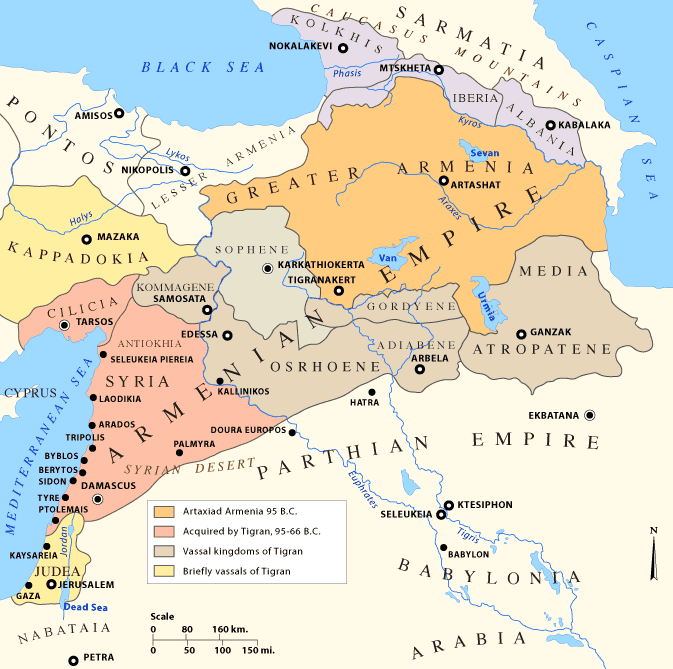
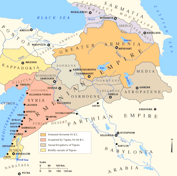
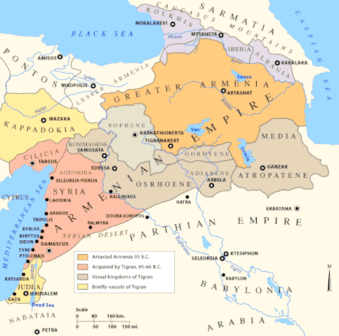
English: Early Armenian Empire of Tigranes, which existed between the final collapse of the Seleucids and the Roman conquest of the eastern Mediterranean. Original text: The Empire of Tigran the Great, 95-66 BC |
| Ημερομηνία |
Uploaded to en.wikipedia on 11 Ιανουαρίου 2007, 20:24
|
| Πηγή |
|
| Δημιουργός | Uploaded to en.wikipedia by en:user:Nareklm |
| άλλες εκδόσεις |
[]
|
.svg)


Αδειοδότηση
[επεξεργασία]

|
Παραχωρείται η άδεια προς αντιγραφή, διανομή και/ή τροποποίηση αυτού του εγγράφου υπό τους όρους της Άδειας Ελεύθερης Τεκμηρίωσης GNU, Έκδοση 1.2 ή οποιασδήποτε νεότερης έκδοσης δημοσιευμένης από το Ίδρυμα Ελεύθερου Λογισμικού· χωρίς Απαράλαχτους Τομείς, χωρίς Κείμενα Εξωφύλλου, και χωρίς Κείμενα Οπισθοφύλλου. Αντίγραφο της άδειας περιλαμβάνεται στην σελίδα με τίτλο GNU Free Documentation License. |
| Το αρχείο διανέμεται υπό την άδεια Creative Commons Αναφορά προέλευσης-Παρόμοια διανομή 3.0 Μη εισαγόμενη | ||
| ||
| Αυτή η ετικέτα άδειας χρήσης προστέθηκε στο αρχείο ως μέρους της αναθεώρησης της άδειας GFDL . |
This permission only applies to images existing on http://armenica.org/ as of 1 January 2007. Any later images do not fall under this permission!
Ιστορικό αρχείου
Πατήστε σε μια ημερομηνία/ώρα για να δείτε το αρχείο όπως εμφανιζόταν εκείνη την χρονική στιγμή.
| Ημερομηνία/Ώρα | Μικρογραφία | Διαστάσεις | Χρήστης | Σχόλιο | |
|---|---|---|---|---|---|
| τρέχον | 14:23, 18 Δεκεμβρίου 2017 | | 673 × 669 (56 KB) | Maproom (συζήτηση | Συνεισφορά) | changed "LESSER A ARMENIA" to "LESSER ARMENIA" |
| 16:59, 28 Μαρτίου 2010 |  | 673 × 669 (56 KB) | Ras67 (συζήτηση | Συνεισφορά) | cropped, watermark removed | |
| 04:02, 13 Ιανουαρίου 2007 |  | 700 × 711 (61 KB) | TigranMets (συζήτηση | Συνεισφορά) | The Armenian Empire... Please see: http://en.wikipedia.org/wiki/Image:20tigranes95-66.gif |
Δεν μπορείτε να αντικαταστήσετε αυτό το αρχείο.
Χρήση αρχείου
Οι ακόλουθες 21 σελίδες χρησιμοποιούν προς αυτό το αρχείο:
- Atlas of Abkhazia
- Atlas of Adjara
- Atlas of Armenia
- Atlas of Artsakh
- Atlas of Azerbaijan
- Atlas of Georgia
- Atlas of Kurdistan
- Top 200 map images that should use vector graphics
- User:Geagea/Israel/2017 December 18
- File:20tigranes95-66.gif (ανακατεύθυνση του αρχείου)
- File:Armenia Minor map first century BC.jpg
- File:Great Armenia.png (ανακατεύθυνση του αρχείου)
- File:Map of the Armenian Empire of Tigranes (English).svg
- File:Maps of the Armenian Empire of Tigranes-es.svg
- File:Maps of the Armenian Empire of Tigranes-fr.svg
- File:Maps of the Armenian Empire of Tigranes-he.svg
- File:Maps of the Armenian Empire of Tigranes-pt.svg
- File:Maps of the Armenian Empire of Tigranes-ru.svg
- File:Maps of the Armenian Empire of Tigranes.gif
- Template:Other versions/Maps of the Armenian Empire of Tigranes
Καθολική χρήση αρχείου
Τα ακόλουθα άλλα wiki χρησιμοποιούν αυτό το αρχείο:
- Χρήση σε af.wikipedia.org
- Χρήση σε arc.wikipedia.org
- Χρήση σε ar.wikipedia.org
- Χρήση σε arz.wikipedia.org
- Χρήση σε azb.wikipedia.org
- Χρήση σε az.wikipedia.org
- Χρήση σε ba.wikipedia.org
- Χρήση σε be-tarask.wikipedia.org
- Χρήση σε be.wikipedia.org
- Χρήση σε bg.wikipedia.org
- Χρήση σε br.wikipedia.org
- Χρήση σε bs.wikipedia.org
Δείτε περισσότερη καθολική χρήση αυτού του αρχείου.
Κατηγορίες:
- Georgia in the 1st century BC
- Maps of Adiabene
- Maps of Cappadocia
- Maps of Caucasian Albania
- Maps of Colchis
- Maps of Commagene
- Maps of Corduene
- Maps of Osrhoene
- Maps of Parthia
- Maps of Sarmatia
- Maps of Sophene
- Maps of ancient Armenia
- Maps of the Kingdom of Iberia
- Maps of the Middle East
- Maps of the history of Armenia
- Maps of the history of Azerbaijan
- Maps of the history of Georgia
- Maps of the history of Iraq
- Maps of the history of Israel
- Maps of the history of Syria
- Maps of the history of Turkey
- Maps of the history of the Caucasus in antiquity
- Maps showing 1st-century BC history