File:MarsCones-ESP 030192 2020.jpg

元のファイル (2,880 × 1,800 ピクセル、ファイルサイズ: 5.22メガバイト、MIME タイプ: image/jpeg)
キャプション
キャプション
概要[編集]
| 解説 |
English: NASA/JPL/University of Arizona
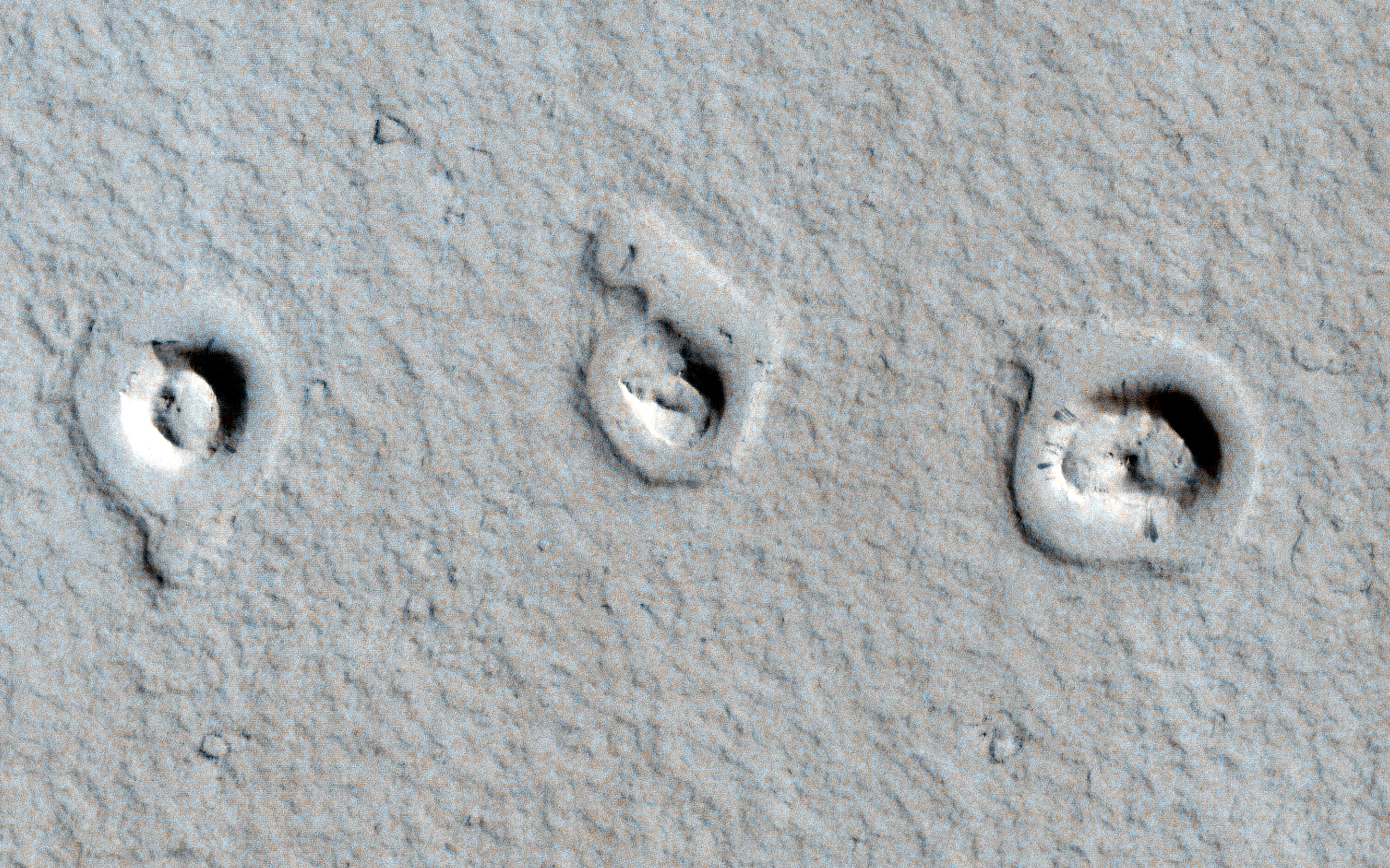
Cones and Inflated Lava Flows ESP_030192_2020 Science Theme: Volcanic Processes http://hirise.lpl.arizona.edu/ESP_030192_2020 https://www.wired.com/wiredscience/2013/01/space-photo-of-the-day-2/?pid=6342 A CTX image shows topographic cones in local depressions here. What are these and how did they form? This image reveals "rootless cones," which form on lava flows that interact with subsurface water. They are in depressions because subsequent lava flowed around the base of the cones, then "inflated." Lava inflation is a process where liquid is injected beneath the solid (thickening) crust and raises the whole surface, often raising it higher than the topography that controlled the initial lava emplacement. This scene is in Amazonis Planitia, a vast region covered by flood lava. The surface is coated by a thin layer of reddish dust, which avalanches down steep slopes to make dark streaks. Written by: Alfred McEwen (audio by Tre Gibbs) (20 February 2013)Acquisition date: 04 January 2013 Local Mars time: 3:14 PM Latitude (centered): 21.965 degrees Longitude (East): 197.807 degrees Range to target site: 288.0 km (180.0 miles) Original image scale range: 57.6 cm/pixel (with 2 x 2 binning) so objects ~173 cm across are resolved Map projected scale: 50 cm/pixel and North is up Map projection: EQUIRECTANGULAR Emission angle: 2.9 degrees Phase angle: 61.9 degrees Solar incidence angle: 64 degrees, with the Sun about 26 degrees above the horizon Solar longitude: 238.2 degrees, Northern Autumn For non-map projected products: North azimuth: 97 degrees Sub-solar azimuth: 327.0 degrees For map-projected products North azimuth: 270 degrees Sub solar azimuth: 141.4 degrees |
| 日付 | |
| 原典 | http://hirise.lpl.arizona.edu/images/wallpaper/2880/ESP_030192_2020.jpg |
| 作者 | NASA/JPL/University of Arizona |
ライセンス[編集]
| このファイルはアメリカ航空宇宙局(NASA)によって作成されたものです。NASAの著作権の方針では、特記事項が無い場合、NASAの資料はパブリックドメインとなります。 (詳しくはTemplate:PD-USGov、NASAの著作権の方針について(英語)又はジェット推進研究所(JPL)の画像使用に関するガイドライン(英語)をご覧ください。) |
||
 |
注意事項:
|
ファイルの履歴
過去の版のファイルを表示するには、その版の日時をクリックしてください。
| 日付と時刻 | サムネイル | 寸法 | 利用者 | コメント | |
|---|---|---|---|---|---|
| 現在の版 | 2013年2月23日 (土) 14:46 | | 2,880 × 1,800 (5.22メガバイト) | Drbogdan (トーク | 投稿記録) | User created page with UploadWizard |
このファイルは上書きできません。
ファイルの使用状況
グローバルなファイル使用状況
以下に挙げる他のウィキがこの画像を使っています:
- en.wikipedia.org での使用状況
- fr.wikipedia.org での使用状況
- ja.wikipedia.org での使用状況
- nl.wikipedia.org での使用状況
- ru.wikipedia.org での使用状況
- sv.wikipedia.org での使用状況
- uk.wikipedia.org での使用状況
- zh.wikipedia.org での使用状況