File:MarsCones-ESP 030192 2020.jpg

原始檔案 (2,880 × 1,800 像素,檔案大小:5.22 MB,MIME 類型:image/jpeg)
說明
說明
摘要
[編輯]
| 描述 |
English: NASA/JPL/University of Arizona
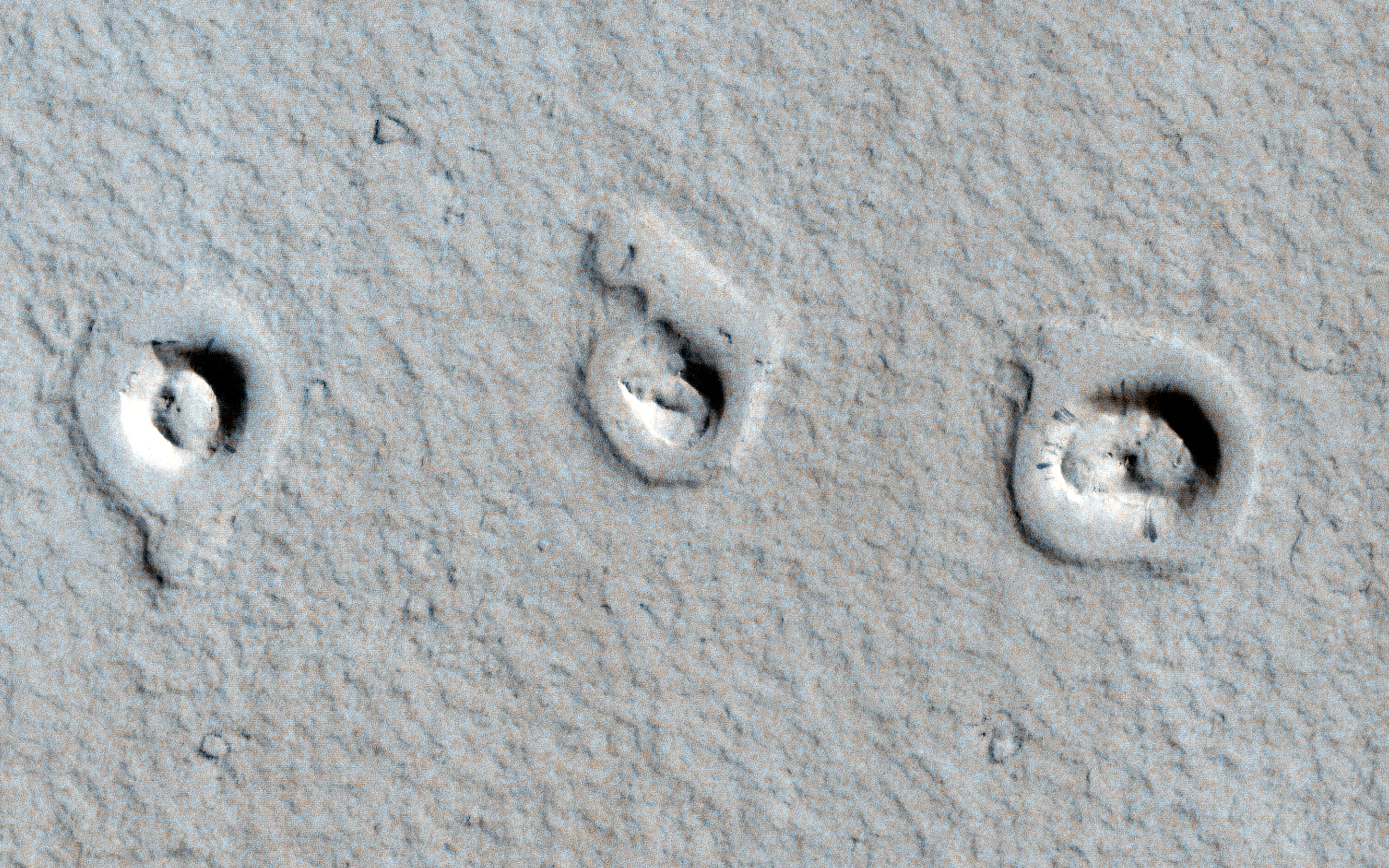
Cones and Inflated Lava Flows ESP_030192_2020 Science Theme: Volcanic Processes http://hirise.lpl.arizona.edu/ESP_030192_2020 https://www.wired.com/wiredscience/2013/01/space-photo-of-the-day-2/?pid=6342 A CTX image shows topographic cones in local depressions here. What are these and how did they form? This image reveals "rootless cones," which form on lava flows that interact with subsurface water. They are in depressions because subsequent lava flowed around the base of the cones, then "inflated." Lava inflation is a process where liquid is injected beneath the solid (thickening) crust and raises the whole surface, often raising it higher than the topography that controlled the initial lava emplacement. This scene is in Amazonis Planitia, a vast region covered by flood lava. The surface is coated by a thin layer of reddish dust, which avalanches down steep slopes to make dark streaks. Written by: Alfred McEwen (audio by Tre Gibbs) (20 February 2013)Acquisition date: 04 January 2013 Local Mars time: 3:14 PM Latitude (centered): 21.965 degrees Longitude (East): 197.807 degrees Range to target site: 288.0 km (180.0 miles) Original image scale range: 57.6 cm/pixel (with 2 x 2 binning) so objects ~173 cm across are resolved Map projected scale: 50 cm/pixel and North is up Map projection: EQUIRECTANGULAR Emission angle: 2.9 degrees Phase angle: 61.9 degrees Solar incidence angle: 64 degrees, with the Sun about 26 degrees above the horizon Solar longitude: 238.2 degrees, Northern Autumn For non-map projected products: North azimuth: 97 degrees Sub-solar azimuth: 327.0 degrees For map-projected products North azimuth: 270 degrees Sub solar azimuth: 141.4 degrees |
| 日期 | |
| 來源 | http://hirise.lpl.arizona.edu/images/wallpaper/2880/ESP_030192_2020.jpg |
| 作者 | NASA/JPL/University of Arizona |
授權條款
[編輯]
| 本作品由NASA創作,屬於公有領域。根據NASA的版權政策:“NASA的創作除非另有聲明否則不受版權保護。”(參見:Template:PD-USGov/zh,NASA版權政策或JPL圖像使用政策) | ||
 |
警告:
|
檔案歷史
點選日期/時間以檢視該時間的檔案版本。
| 日期/時間 | 縮圖 | 尺寸 | 用戶 | 備註 | |
|---|---|---|---|---|---|
| 目前 | 2013年2月23日 (六) 14:46 | | 2,880 × 1,800(5.22 MB) | Drbogdan(對話 | 貢獻) | User created page with UploadWizard |
無法覆蓋此檔案。
檔案用途
全域檔案使用狀況
以下其他 wiki 使用了這個檔案:
- en.wikipedia.org 的使用狀況
- fr.wikipedia.org 的使用狀況
- ja.wikipedia.org 的使用狀況
- nl.wikipedia.org 的使用狀況
- ru.wikipedia.org 的使用狀況
- sv.wikipedia.org 的使用狀況
- uk.wikipedia.org 的使用狀況
- zh.wikipedia.org 的使用狀況