File:MarsCuriosityRover-TraverseMap-Sol-0746-20140911.jpg
跳转到导航
跳转到搜索

本预览的尺寸:776 × 600像素。 其他分辨率:311 × 240像素 | 621 × 480像素 | 994 × 768像素 | 1,280 × 989像素 | 2,560 × 1,978像素 | 3,300 × 2,550像素。
原始文件 (3,300 × 2,550像素,文件大小:1.34 MB,MIME类型:image/jpeg)
说明
说明
添加一行文字以描述该文件所表现的内容
摘要
[编辑]
| 描述 |
English: 09.11.2014
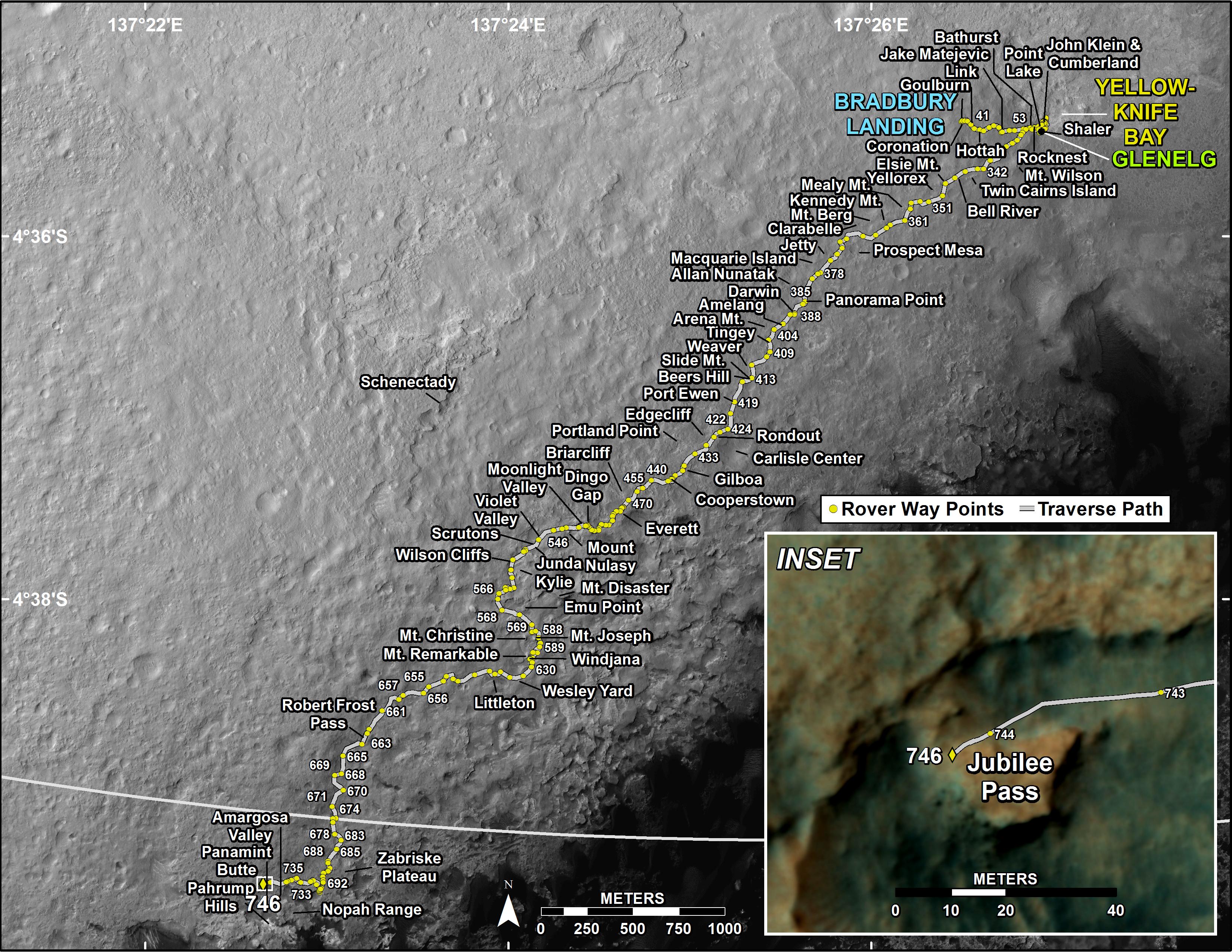
Curiosity's Traverse Map Through Sol 746 - Arrival at the slopes of Mount Sharp in Gale Crater on the planet Mars. http://mars.jpl.nasa.gov/msl/multimedia/images/?ImageID=6587 This map shows the route driven by NASA's Mars rover Curiosity through the 746 Martian day, or sol, of the rover's mission on Mars (September 11, 2014). Numbering of the dots along the line indicate the sol number of each drive. North is up. The scale bar is 1 kilometer (~0.62 mile). From Sol 744 to Sol 746, Curiosity had driven a straight line distance of about 26.19 feet (7.983 meters). The base image from the map is from the High Resolution Imaging Science Experiment Camera (HiRISE) in NASA's Mars Reconnaissance Orbiter. |
| 日期 | |
| 来源 | http://mars.jpl.nasa.gov/msl/images/MSL_TraverseMap_Sol0746-full.jpg |
| 作者 | NASA/JPL-Caltech/Univ. of Arizona |
许可协议
[编辑]
| 本文件完全由NASA创作,在美国属于公有领域。根据NASA的版权方针,NASA的材料除非另有声明否则不受版权保护。(参见Template:PD-USGov/zh、NASA版权方针页面或JPL图片使用方针。) | ||
 |
警告:
|
文件历史
点击某个日期/时间查看对应时刻的文件。
| 日期/时间 | 缩略图 | 大小 | 用户 | 备注 | |
|---|---|---|---|---|---|
| 当前 | 2014年9月19日 (五) 20:01 | | 3,300 × 2,550(1.34 MB) | Drbogdan(留言 | 贡献) | User created page with UploadWizard |
您不可以覆盖此文件。
文件用途
没有页面使用本文件。
全域文件用途
以下其他wiki使用此文件:
- en.wikipedia.org上的用途
- tr.wikipedia.org上的用途
- uk.wikipedia.org上的用途
- zh.wikipedia.org上的用途