File:Mars Crustal Magnetism MGS.png
跳转到导航
跳转到搜索

本预览的尺寸:800 × 549像素。 其他分辨率:320 × 219像素 | 640 × 439像素 | 1,024 × 702像素 | 1,280 × 878像素 | 1,524 × 1,045像素。
原始文件 (1,524 × 1,045像素,文件大小:1.44 MB,MIME类型:image/png)
说明
说明
添加一行文字以描述该文件所表现的内容
摘要
[编辑]
| 描述 |
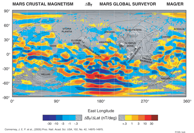
English: The global map is built up from many thousands of orbits at constant altitude (mapping orbit), and uses colors to represent the strength and direction of the field caused by crustal magnetization.
It's originally in TIFF format. I transformed it into PNG format by Photoshop 7.0.1 to make it visible on the net. |
| 日期 | |
| 来源 | http://www.nasa.gov/centers/goddard/news/topstory/2005/mgs_plates.html |
| 作者 | NASA |
许可协议
[编辑]
| 本文件完全由NASA创作,在美国属于公有领域。根据NASA的版权方针,NASA的材料除非另有声明否则不受版权保护。(参见Template:PD-USGov/zh、NASA版权方针页面或JPL图片使用方针。) | ||
 |
警告:
|
文件历史
点击某个日期/时间查看对应时刻的文件。
| 日期/时间 | 缩略图 | 大小 | 用户 | 备注 | |
|---|---|---|---|---|---|
| 当前 | 2009年5月28日 (四) 05:20 | | 1,524 × 1,045(1.44 MB) | Areong(留言 | 贡献) | {{Information |Description={{en|1=The global map is built up from many thousands of orbits at constant altitude (mapping orbit), and uses colors to represent the strength and direction of the field caused by crustal magnetization. It's originally in TIF |
您不可以覆盖此文件。
文件用途
以下页面使用本文件:
全域文件用途
以下其他wiki使用此文件:
- be.wikipedia.org上的用途
- en.wikipedia.org上的用途
- fr.wikipedia.org上的用途
- fr.wikibooks.org上的用途
- hy.wikipedia.org上的用途
- nl.wikipedia.org上的用途
- pt.wikipedia.org上的用途
- ru.wikipedia.org上的用途
- uk.wikipedia.org上的用途
- zh.wikipedia.org上的用途