File:Masirah.jpg
跳至導覽
跳至搜尋

預覽大小:503 × 599 像素。 其他解析度:201 × 240 像素 | 403 × 480 像素 | 996 × 1,186 像素。
原始檔案 (996 × 1,186 像素,檔案大小:751 KB,MIME 類型:image/jpeg)
說明
說明
添加單行說明來描述出檔案所代表的內容
摘要
[編輯]
| 描述 |
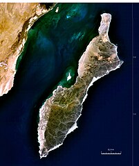
English: Satellite Image of Masirah Island, Oman |
| 日期 | 2000年代 |
| 來源 | NASA World Wind screen shot |
| 作者 | NASA |
授權條款
[編輯]
| 本圖像屬於公有領域,因其為NASA的World Wind衛星地圖瀏覽器的一張截圖,且使用了公有領域圖層,如Blue Marble、MODIS、Landsat、SRTM、USGS、GLOBE等。
|
 |
檔案歷史
點選日期/時間以檢視該時間的檔案版本。
| 日期/時間 | 縮圖 | 尺寸 | 使用者 | 備註 | |
|---|---|---|---|---|---|
| 目前 | 2010年8月24日 (二) 21:13 | | 996 × 1,186(751 KB) | Ratzer(留言 | 貢獻) | {{Information |Description={{en|1=Satellite Image of Masirah Island, Oman}} |Source=NASA World Wind screen shot |Author=NASA |Date=2000s |Permission= |other_versions= }} Category:Satellite pictures of Oman Category:Masirah Island |
無法覆蓋此檔案。
檔案用途
下列頁面有用到此檔案:
全域檔案使用狀況
以下其他 wiki 使用了這個檔案:
- ar.wikipedia.org 的使用狀況
- arz.wikipedia.org 的使用狀況
- ca.wikipedia.org 的使用狀況
- ceb.wikipedia.org 的使用狀況
- de.wikipedia.org 的使用狀況
- en.wikipedia.org 的使用狀況
- en.wikivoyage.org 的使用狀況
- es.wikipedia.org 的使用狀況
- fi.wikipedia.org 的使用狀況
- fr.wikipedia.org 的使用狀況
- gl.wikipedia.org 的使用狀況
- he.wikivoyage.org 的使用狀況
- hu.wikipedia.org 的使用狀況
- it.wikipedia.org 的使用狀況
- it.wikivoyage.org 的使用狀況
- ja.wikipedia.org 的使用狀況
- nn.wikipedia.org 的使用狀況
- no.wikipedia.org 的使用狀況
- pl.wikipedia.org 的使用狀況
- uk.wikipedia.org 的使用狀況
- ur.wikipedia.org 的使用狀況
- www.wikidata.org 的使用狀況
- zh.wikipedia.org 的使用狀況