File:Maskat & Oman map.png
Naviqasiyaya keç
Axtarışa keç

Sınaq göstərişi ölçüsü: 567 × 599 piksel. Digər ölçülər: 227 × 240 piksel | 454 × 480 piksel | 763 × 806 piksel.
Faylın orijinalı (763 × 806 piksel, fayl həcmi: 21 KB, MIME növü: image/png)
Captions
Captions
Add a one-line explanation of what this file represents

|
This map image could be re-created using vector graphics as an SVG file. This has several advantages; see Commons:Media for cleanup for more information. If an SVG form of this image is available, please upload it and afterwards replace this template with
{{vector version available|new image name}}.
It is recommended to name the SVG file “Maskat & Oman map.svg”—then the template Vector version available (or Vva) does not need the new image name parameter. |
| İzah |
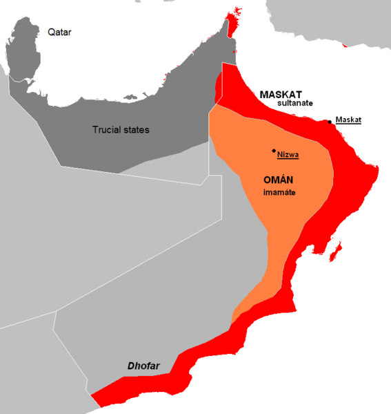
English: The approximate map of historic state of Mascat and Oman.
Čeština: Přibližná mapa historického státu Maskat a Omán |
| Tarix | (UTC) |
| Mənbə | |
| Müəllif |
|
| Digər versiyalar | العربيَّة |
| Bu təsvirin redaktəsi, orijinala əsaslanaraq rəqəmsal qaydadadır. Dəyişiklik: de facto new map, viz. description. İlkin təsvir buradadır: Al Hajar mountain woodlands map.png. Redaktə etdi Kolomaznik.
|
| Mən, bu əsərin müəllif hüquqlarının sahibi kimi, əsəri ictimai mülkiyyətə verirəm. Bu icazə bütün dünyada qüvvədədir. In some countries this may not be legally possible; if so: Bunun qanunla mümkün olmadığı hallarda: İstənilən şəxsə, istənilən məqsəd üçün, qanunlar tərəfindən qadağan edilməyincə, heç bir şərt qoymadan bu işdən istifadə haqqını bağışlayıram. |
Orijinal yükləmə gündəliyi
[redaktə]
This image is a derivative work of the following images:
- File:AT1306_map.png licensed with PD-self
- 2008-02-27T09:16:44Z Doreano 763x806 (23794 Bytes) {{Information |Description=Gulf of Oman desert and semi-desert ecoregion map |Source=self-made |Date=2008/2/27 |Author= [[User:Altatoron|Altatoron]] |Permission= |other_versions= }} [[Category:Biomes]] [[Category:Biogeography
- File:AT0801_map.png licensed with PD-self
- 2008-02-27T09:10:47Z Doreano 676x806 (18852 Bytes) {{Information |Description=Al Hajar montane woodlands ecoregion map |Source=self-made |Date=2008/2/27 |Author= [[User:Altatoron|Altatoron]] |Permission= |other_versions= }} [[Category:Biomes]] [[Category:Biogeography]] [[Cate
Uploaded with derivativeFX
Faylın tarixçəsi
Faylın əvvəlki versiyasını görmək üçün gün/tarix bölməsindəki tarixlərə klikləyin.
| Tarix/Vaxt | Miniatür | Ölçülər | İstifadəçi | Şərh | |
|---|---|---|---|---|---|
| hal-hazırkı | 22:36, 7 iyul 2015 | | 763 × 806 (21 KB) | History of Persia (müzakirə | töhfələr) | Made it easier to understand. |
| 19:06, 28 may 2010 |  | 763 × 806 (27 KB) | Kolomaznik (müzakirə | töhfələr) | {{Information |Description={{en}}The approximate map of historic state of Mascat and Oman. {{cs}}Přibližná mapa historického státu Maskat a Omán |Source=*File:AT1306_map.png *File:AT0801_map.png |Date=2010-05-28 19:02 (UTC) |Author=*[[:F |
Siz bu faylı yenidən yükləyə bilməzsiniz.
Faylın istifadəsi
Bu faylı istifadə edən səhifə yoxdur.
Faylın qlobal istifadəsi
Bu fayl aşağıdakı vikilərdə istifadə olunur:
- ar.wikipedia.org layihəsində istifadəsi
- az.wikipedia.org layihəsində istifadəsi
- cs.wikipedia.org layihəsində istifadəsi
- de.wikipedia.org layihəsində istifadəsi
- el.wikipedia.org layihəsində istifadəsi
- en.wikipedia.org layihəsində istifadəsi
- es.wikipedia.org layihəsində istifadəsi
- eu.wikipedia.org layihəsində istifadəsi
- fa.wikipedia.org layihəsində istifadəsi
- fi.wikipedia.org layihəsində istifadəsi
- fr.wikipedia.org layihəsində istifadəsi
- he.wikipedia.org layihəsində istifadəsi
- id.wikipedia.org layihəsində istifadəsi
- it.wikipedia.org layihəsində istifadəsi
- ko.wikipedia.org layihəsində istifadəsi
- mn.wikipedia.org layihəsində istifadəsi
- ms.wikipedia.org layihəsində istifadəsi
- nl.wikipedia.org layihəsində istifadəsi
- pl.wikipedia.org layihəsində istifadəsi
- pt.wikipedia.org layihəsində istifadəsi
- ru.wikipedia.org layihəsində istifadəsi
- sl.wikipedia.org layihəsində istifadəsi
- th.wikipedia.org layihəsində istifadəsi
- tr.wikipedia.org layihəsində istifadəsi
- uk.wikipedia.org layihəsində istifadəsi
- vi.wikipedia.org layihəsində istifadəsi
- www.wikidata.org layihəsində istifadəsi
- zh.wikipedia.org layihəsində istifadəsi