File:Mauryan Empire Map-zh-classical.png
跳至導覽
跳至搜尋
無更高解析度可提供。
Mauryan_Empire_Map-zh-classical.png (400 × 337 像素,檔案大小:10 KB,MIME 類型:image/png)
說明
說明
添加單行說明來描述出檔案所代表的內容

|
本圖片是以PNG、GIF或JPEG格式上傳。然而,其中包含的資料或訊息,應該重新建立成可縮放向量圖形(SVG)檔案,以更有效率或更準確的方式儲存。如有可能,請上傳本圖片的SVG格式版本。在上傳之後,請修改維基各姊妹計畫中所有使用舊版圖片的條目(列在圖像連結章節中),替換為新版圖片,並在舊圖片的描述頁中加入{{Vector version available|新圖片名稱.svg}}模板,同時移除本模板。
|

|
This map has been uploaded by Electionworld from en.wikipedia.org to enable the |
摘要[編輯]
| 描述 |
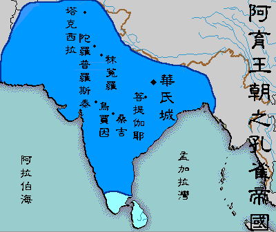
English: A political map of the Mauryan Empire, including notable cities, such as the capital Pataliputra, and site of the Buddha's enlightenment.
Original picture was uploaded here.
The Classical Chinese Modification is made by User:Itsmine. |
| 日期 | File was made on August 3, 2006, using Microsoft Paint. |
| 來源 | Based upon common poltical maps of the Mauryan Empire, created from this template: Image:Marathas.GIF |
| 作者 |
授權條款[編輯]
| 此作品已由其作者,Vastu,釋出至公有領域。此授權條款在全世界均適用。 這可能在某些國家不合法,如果是的話: |
檔案歷史
點選日期/時間以檢視該時間的檔案版本。
| 日期/時間 | 縮圖 | 尺寸 | 使用者 | 備註 | |
|---|---|---|---|---|---|
| 目前 | 2007年5月12日 (六) 08:41 | | 400 × 337(10 KB) | Itsmine(留言 | 貢獻) | {{ew|en|Vastu}} {{ShouldBeSVG|map}} ==Description== A poltical map of the Mauryan Empire, including notable cities, such as the capital Pataliputra, and site of the Buddha's enlightenment. Original picture was uploaded [[:Image:Mauryan Emp |
無法覆蓋此檔案。
檔案用途
下列頁面有用到此檔案: