File:MazandaranDamavand.PNG
跳转到导航
跳转到搜索
本预览的尺寸:800 × 293像素。 其他分辨率:320 × 117像素 | 931 × 341像素。
原始文件 (931 × 341像素,文件大小:34 KB,MIME类型:image/png)
说明
说明
添加一行文字以描述该文件所表现的内容
| 描述 |
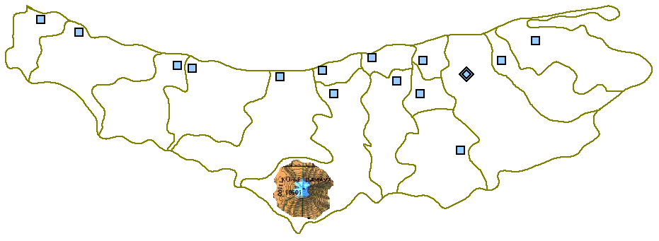
English: Map of Māzandarān Province showing the location of Mount Damāvand in the south of Amol County. |
| 日期 | |
| 来源 |
本檔案衍生自: MazandaranPlainMap.PNG |
| 作者 | Siamax |
| |
本作品已被作者中文维基百科项目的Siamax释出到公有领域。这适用于全世界。 如果这样做不合法的话: |
原始上传日志[编辑]
原始描述頁面位於這裡。下列使用者名稱均來自en.wikipedia。
- 2006-09-06 14:55 Siamax (Author: http://en.wikipedia.org/wiki/User:Siamax Source: http://en.wikipedia.org/wiki/Image:MazandaranPlainMap.PNG Tag: Damavand location in Mazandaran)
文件历史
点击某个日期/时间查看对应时刻的文件。
| 日期/时间 | 缩略图 | 大小 | 用户 | 备注 | |
|---|---|---|---|---|---|
| 当前 | 2007年8月27日 (一) 22:52 | 931 × 341(34 KB) | Hessam(留言 | 贡献) | From en:Image:MazandaranDamavand.PNG {{PD-user-w|en|English Wikipedia|Siamax}} {{Information |Description= Map of Māzandarān province showing the location of mount Damāvand in the south. |Source= http://en.wikipedia.org/wiki/Image:MazandaranPla |
您不可以覆盖此文件。
文件用途
没有页面使用本文件。
全域文件用途
以下其他wiki使用此文件:
- ar.wikipedia.org上的用途
- ast.wikipedia.org上的用途
- az.wikipedia.org上的用途
- ca.wikipedia.org上的用途
- cs.wikipedia.org上的用途
- cv.wikipedia.org上的用途
- en.wikipedia.org上的用途
- es.wikipedia.org上的用途
- fa.wikipedia.org上的用途
- fi.wikipedia.org上的用途
- kk.wikipedia.org上的用途
- mzn.wikipedia.org上的用途
- ru.wikipedia.org上的用途
- uk.wikipedia.org上的用途
- uz.wikipedia.org上的用途
- zh.wikipedia.org上的用途