File:Mekkhala September 30 2008.jpg
跳至導覽
跳至搜尋

預覽大小:458 × 599 像素。 其他解析度:183 × 240 像素 | 367 × 480 像素 | 587 × 768 像素 | 783 × 1,024 像素 | 1,566 × 2,048 像素 | 5,200 × 6,800 像素。
原始檔案 (5,200 × 6,800 像素,檔案大小:4.57 MB,MIME 類型:image/jpeg)
說明
說明
添加單行說明來描述出檔案所代表的內容
摘要[編輯]
| 描述 |
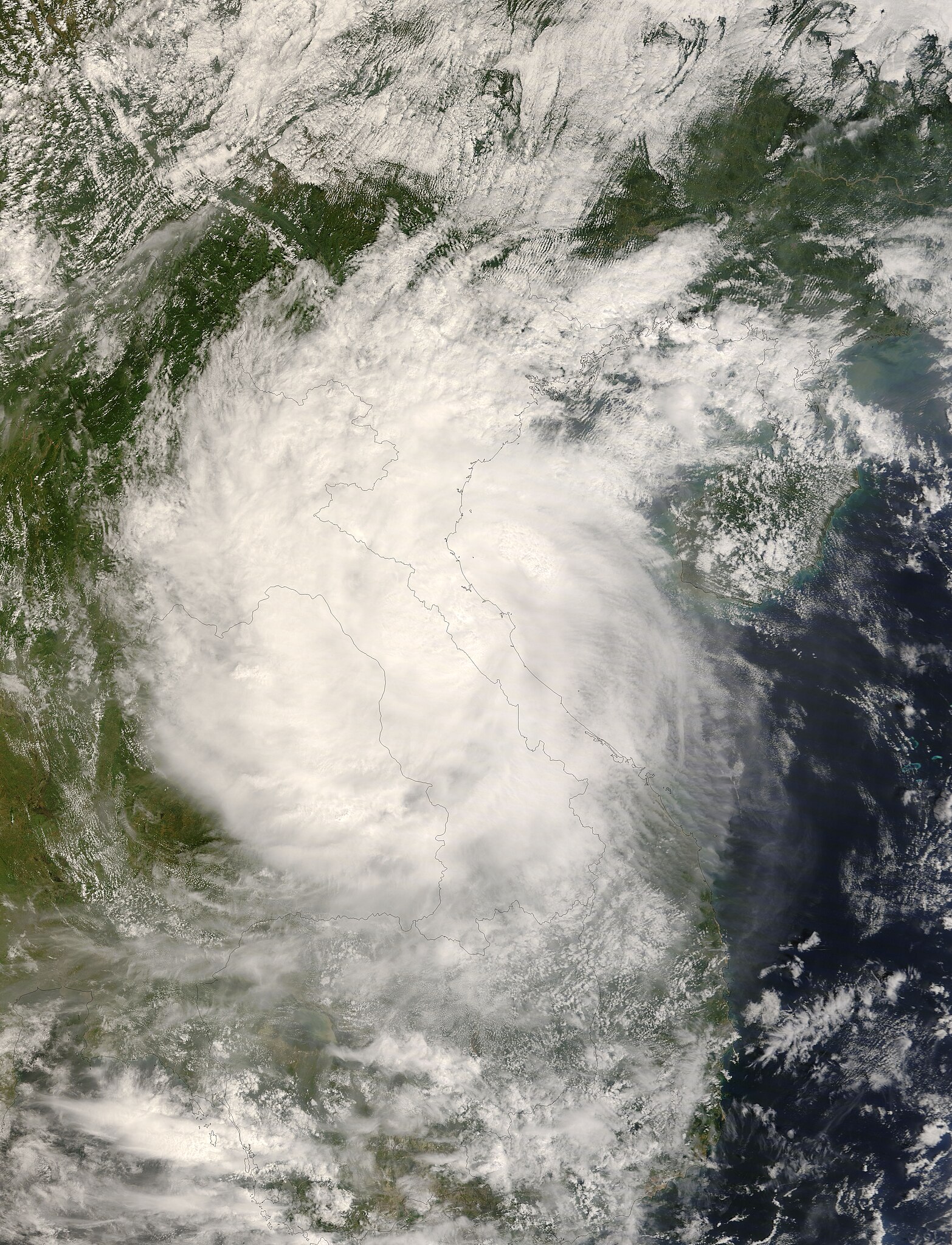
English: The Moderate Resolution Imaging Spectroradiometer (MODIS) on NASA’s Terra satellite captured this photo-like image of Tropical Storm Mekkhala over Vietnam, Laos, and Thailand on September 30, 2008, shortly after the storm came ashore. Mikkhala hit Vietnam with winds of 100 kilometers per hour (63 miles per hour or 55 knots), according to estimates from the Joint Typhoon Warning Center. The storm has the distinctive round shape of a tropical cyclone and covers a large area, from the Chinese border to southern Laos.
Mekkhala brought winds and heavy rain to Vietnam, causing eight deaths, reported the Associated Press on October 2. Northern Vietnam was still recovering from devastating flooding caused by Typhoon Hagupit, which drenched the region a few days earlier. The high-resolution image provided above is at MODIS’ full spatial resolution (level of detail) of 250 meters per pixel. The MODIS Rapid Response System provides this image at additional resolutions. You can also download a 250-meter-resolution KMZ file of the storm suitable for use with Google Earth. |
| 日期 | |
| 來源 | https://earthobservatory.nasa.gov/NaturalHazards/view.php?id=35453 |
| 作者 | NASA image by Jeff Schmaltz, MODIS Rapid Response Team, Goddard Space Flight Center. Caption by Holli Riebeek. |
授權條款[編輯]
| 本作品由NASA創作,屬於公有領域。根據NASA的版權政策:“NASA的創作除非另有聲明否則不受版權保護。”(參見:Template:PD-USGov/zh,NASA版權政策或JPL圖像使用政策) | ||
 |
警告:
|
檔案歷史
點選日期/時間以檢視該時間的檔案版本。
| 日期/時間 | 縮圖 | 尺寸 | 用戶 | 備註 | |
|---|---|---|---|---|---|
| 目前 | 2008年10月3日 (五) 00:28 | | 5,200 × 6,800(4.57 MB) | Albamhandae(對話 | 貢獻) | New version |
| 2008年10月1日 (三) 13:17 |  | 334 × 351(54 KB) | Iune(對話 | 貢獻) | Category:Severe Tropical Storm Mekkala (2008) | |
| 2008年10月1日 (三) 06:58 |  | 5,416 × 8,120(7.93 MB) | Albamhandae(對話 | 貢獻) | {{Information |Description={{en|1=Severe Tropical Storm Mekkhala, as seen from Terra Satellite on September 30 2008.}} {{ko|1=2008년 9월 30일에 테라 위성으로 촬영한 [[:w:ko:2008 |
無法覆蓋此檔案。
檔案用途
沒有使用此檔案的頁面。
全域檔案使用狀況
以下其他 wiki 使用了這個檔案:
- de.wikipedia.org 的使用狀況
- en.wikipedia.org 的使用狀況
- ja.wikipedia.org 的使用狀況
- pt.wikipedia.org 的使用狀況
- vi.wikipedia.org 的使用狀況
- zh.wikipedia.org 的使用狀況