File:Mengjiang map 1939.svg
跳转到导航
跳转到搜索

此SVG文件的PNG预览的大小:634 × 387像素。 其他分辨率:320 × 195像素 | 640 × 391像素 | 1,024 × 625像素 | 1,280 × 781像素 | 2,560 × 1,563像素。
原始文件 (SVG文件,尺寸为634 × 387像素,文件大小:2.23 MB)
说明
说明
添加一行文字以描述该文件所表现的内容
| 描述 |
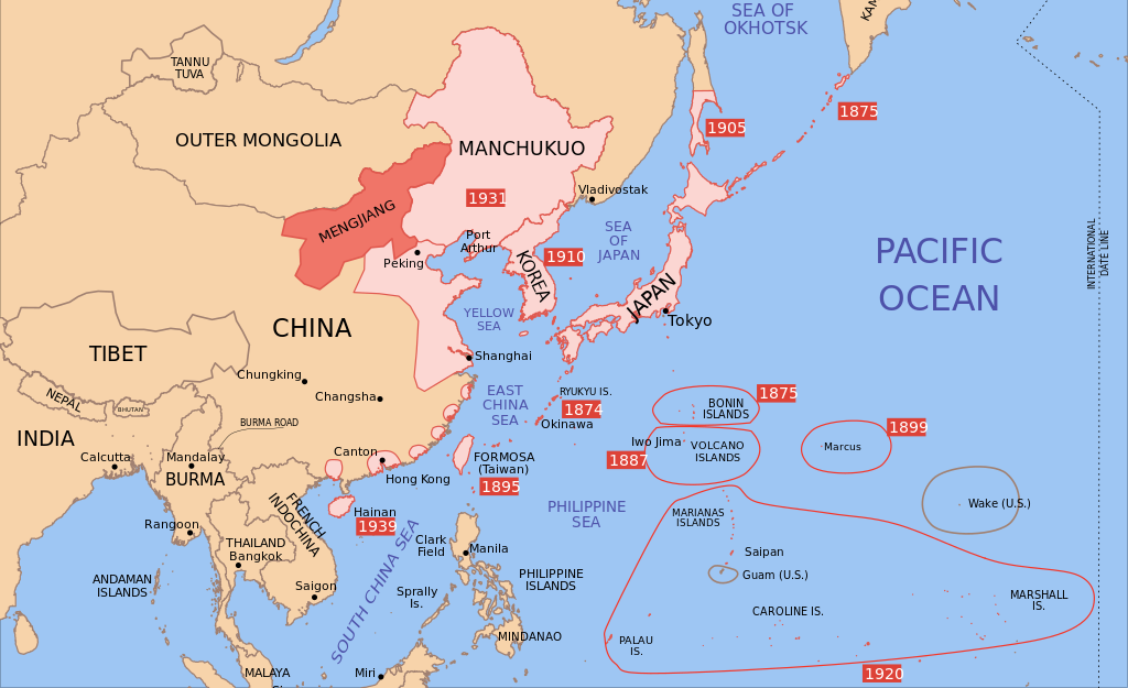
Català: Mapa de Mengkukuo en setembre del 1939 English: A map of Mengjiang, 1939-09-01. Dates shown indicate the approximate year that the various powers gain control of their possessions. Japanese control of territory in China was tenuous. |
| 日期 | |
| 来源 | |
| 作者 |
|
| 其他版本 |
|


我,本作品著作权人,特此采用以下许可协议发表本作品:
本文件采用知识共享署名-相同方式共享 3.0 未本地化版本许可协议授权。
- 您可以自由地:
- 共享 – 复制、发行并传播本作品
- 修改 – 改编作品
- 惟须遵守下列条件:
- 署名 – 您必须对作品进行署名,提供授权条款的链接,并说明是否对原始内容进行了更改。您可以用任何合理的方式来署名,但不得以任何方式表明许可人认可您或您的使用。
- 相同方式共享 – 如果您再混合、转换或者基于本作品进行创作,您必须以与原先许可协议相同或相兼容的许可协议分发您贡献的作品。

|
已授权您依据自由软件基金会发行的无固定段落及封面封底文字(Invariant Sections, Front-Cover Texts, and Back-Cover Texts)的GNU自由文件许可协议1.2版或任意后续版本的条款,复制、传播和/或修改本文件。该协议的副本请见“GNU Free Documentation License”。 |
您可以选择您需要的许可协议。
原始上传日志
[编辑]
This image is a derivative work of the following images:
- Image:Pacific_Area_-_The_Imperial_Powers_1939_-_Map.svg licensed with Cc-by-sa-3.0, GFDL
- 2008-08-21T02:54:43Z Emok 1039x814 (4703043 Bytes) {{Information |Description= |Source= |Date= |Author= |Permission= |other_versions= }}
- 2008-08-21T02:44:29Z Emok 1039x814 (4702923 Bytes) {{Information |Description= |Source= |Date= |Author= |Permission= |other_versions= }}
- 2008-08-08T01:16:33Z Emok 1039x814 (4678233 Bytes) {{Information |Description= |Source= |Date= |Author= |Permission= |other_versions= }}
- 2008-08-08T00:07:48Z Emok 1039x814 (4669659 Bytes) {{Information |Description= |Source= |Date= |Author= |Permission= |other_versions= }}
- 2008-08-07T05:03:23Z Emok 1039x814 (4669195 Bytes) {{Information |Description= |Source= |Date= |Author= |Permission= |other_versions= }}
- 2008-08-07T04:28:58Z Emok 1039x814 (4623405 Bytes) {{Information |Description= |Source= |Date= |Author= |Permission= |other_versions= }}
- 2008-08-07T04:02:57Z Emok 1039x814 (4602891 Bytes) {{Information |Description= |Source= |Date= |Author= |Permission= |other_versions= }}
- 2008-08-07T03:24:03Z Emok 1039x814 (4669511 Bytes) {{Information |Description= |Source= |Date= |Author= |Permission= |other_versions= }}
- 2008-08-04T16:59:39Z Emok 1039x814 (6442489 Bytes) {{Information |Description= |Source= |Date= |Author= |Permission= |other_versions= }}
- 2008-08-04T05:38:24Z Emok 1039x814 (6427678 Bytes) {{Information |Description= |Source= |Date= |Author= |Permission= |other_versions= }} [[Category:Imperialism]] [[Category:Oceania]]
- 2008-08-04T05:26:00Z Emok 104x82 (4765313 Bytes) {{Information |Description={{en|1=A map of the Imperial Powers of the Pacific, 1939-09-01. }} |Source=*[[:Image:World2Hires_filled_mercator.svg|]] |Date=2008-08-04 05:22 (UTC) |Author=*derivative work: ~~~ *[[:Image:World2Hir
Uploaded with derivativeFX
文件历史
点击某个日期/时间查看对应时刻的文件。
| 日期/时间 | 缩略图 | 大小 | 用户 | 备注 | |
|---|---|---|---|---|---|
| 当前 | 2023年9月16日 (六) 14:43 | | 634 × 387(2.23 MB) | KajenCAT(留言 | 贡献) | File uploaded using svgtranslate tool (https://svgtranslate.toolforge.org/). Added translation for ca. |
| 2023年9月16日 (六) 13:08 |  | 634 × 387(2.23 MB) | KajenCAT(留言 | 贡献) | File uploaded using svgtranslate tool (https://svgtranslate.toolforge.org/). Added translation for ca. | |
| 2021年11月2日 (二) 17:25 |  | 634 × 387(2.2 MB) | Nv7801(留言 | 贡献) | Chungking, Hainan | |
| 2021年11月2日 (二) 17:22 |  | 634 × 387(2.2 MB) | Nv7801(留言 | 贡献) | Saipan | |
| 2010年8月27日 (五) 01:39 |  | 634 × 387(2.21 MB) | Splittist(留言 | 贡献) | No reason for Xinjiang to have separate borders from China | |
| 2009年5月30日 (六) 23:35 |  | 634 × 387(2.21 MB) | SelfQ~commonswiki(留言 | 贡献) | Cluttering and removal of key elements is not acceptable. If you want a Chineese version please upload on under its own file name. | |
| 2009年5月17日 (日) 10:43 |  | 1,300 × 1,201(864 KB) | Xiamipi(留言 | 贡献) | 增加中文说明 | |
| 2008年8月21日 (四) 02:58 |  | 634 × 387(2.21 MB) | Emok(留言 | 贡献) | {{Information |Description={{en|1=A map of Mengjiang, 1939-09-01. Dates shown indicate the approximate year that the various powers gain control of their possessions. Japanese control of territory in China was tenuous.}} |Source=*[[:Image:Pacific_Area_-_T |
您不可以覆盖此文件。
文件用途
以下9个页面使用本文件:
- User:Magog the Ogre/Multilingual legend/2021 November 1-10
- User:Magog the Ogre/Multilingual legend/2023 September 16-20
- File:Dadao map 1939.svg
- File:Imperial Japan map 1939.svg
- File:Korea map 1939.svg
- File:Manchukuo map 1939.svg
- File:Mengjiang map 1939.svg
- File:Pacific Area - The Imperial Powers 1939 - Map.svg
- File:Pacific Area - The Imperial Powers 1939 - Map mk.svg
全域文件用途
以下其他wiki使用此文件:
- ca.wikipedia.org上的用途
- cs.wikipedia.org上的用途
- de.wikipedia.org上的用途
- en.wikipedia.org上的用途
- fi.wikipedia.org上的用途
- id.wikipedia.org上的用途
- it.wikipedia.org上的用途
- mk.wikipedia.org上的用途
- nl.wikipedia.org上的用途
- no.wikipedia.org上的用途
- pl.wikipedia.org上的用途
- simple.wikipedia.org上的用途
- zh.wikipedia.org上的用途