File:Mengjiang map 1939.svg
跳至導覽
跳至搜尋

此 SVG 檔案的 PNG 預覽的大小:634 × 387 像素。 其他解析度:320 × 195 像素 | 640 × 391 像素 | 1,024 × 625 像素 | 1,280 × 781 像素 | 2,560 × 1,563 像素。
原始檔案 (SVG 檔案,表面大小:634 × 387 像素,檔案大小:2.23 MB)
說明
說明
添加單行說明來描述出檔案所代表的內容
| 描述 |
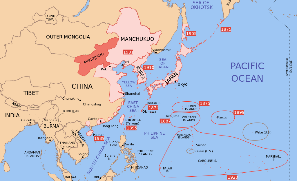
Català: Mapa de Mengkukuo en setembre del 1939 English: A map of Mengjiang, 1939-09-01. Dates shown indicate the approximate year that the various powers gain control of their possessions. Japanese control of territory in China was tenuous. |
| 日期 | |
| 來源 | |
| 作者 |
|
| 其他版本 |
|


我,本作品的著作權持有者,決定用以下授權條款發佈本作品:
此檔案採用創用CC 姓名標示-相同方式分享 3.0 未在地化版本授權條款。
- 您可以自由:
- 分享 – 複製、發佈和傳播本作品
- 重新修改 – 創作演繹作品
- 惟需遵照下列條件:
- 姓名標示 – 您必須指名出正確的製作者,和提供授權條款的連結,以及表示是否有對內容上做出變更。您可以用任何合理的方式來行動,但不得以任何方式表明授權條款是對您許可或是由您所使用。
- 相同方式分享 – 如果您利用本素材進行再混合、轉換或創作,您必須基於如同原先的相同或兼容的條款,來分布您的貢獻成品。

|
已授權您依據自由軟體基金會發行的無固定段落、封面文字和封底文字GNU自由文件授權條款1.2版或任意後續版本,對本檔進行複製、傳播和/或修改。該協議的副本列在GNU自由文件授權條款中。 |
您可以選擇您需要的授權條款。
原始上傳日誌[編輯]
This image is a derivative work of the following images:
- Image:Pacific_Area_-_The_Imperial_Powers_1939_-_Map.svg licensed with Cc-by-sa-3.0, GFDL
- 2008-08-21T02:54:43Z Emok 1039x814 (4703043 Bytes) {{Information |Description= |Source= |Date= |Author= |Permission= |other_versions= }}
- 2008-08-21T02:44:29Z Emok 1039x814 (4702923 Bytes) {{Information |Description= |Source= |Date= |Author= |Permission= |other_versions= }}
- 2008-08-08T01:16:33Z Emok 1039x814 (4678233 Bytes) {{Information |Description= |Source= |Date= |Author= |Permission= |other_versions= }}
- 2008-08-08T00:07:48Z Emok 1039x814 (4669659 Bytes) {{Information |Description= |Source= |Date= |Author= |Permission= |other_versions= }}
- 2008-08-07T05:03:23Z Emok 1039x814 (4669195 Bytes) {{Information |Description= |Source= |Date= |Author= |Permission= |other_versions= }}
- 2008-08-07T04:28:58Z Emok 1039x814 (4623405 Bytes) {{Information |Description= |Source= |Date= |Author= |Permission= |other_versions= }}
- 2008-08-07T04:02:57Z Emok 1039x814 (4602891 Bytes) {{Information |Description= |Source= |Date= |Author= |Permission= |other_versions= }}
- 2008-08-07T03:24:03Z Emok 1039x814 (4669511 Bytes) {{Information |Description= |Source= |Date= |Author= |Permission= |other_versions= }}
- 2008-08-04T16:59:39Z Emok 1039x814 (6442489 Bytes) {{Information |Description= |Source= |Date= |Author= |Permission= |other_versions= }}
- 2008-08-04T05:38:24Z Emok 1039x814 (6427678 Bytes) {{Information |Description= |Source= |Date= |Author= |Permission= |other_versions= }} [[Category:Imperialism]] [[Category:Oceania]]
- 2008-08-04T05:26:00Z Emok 104x82 (4765313 Bytes) {{Information |Description={{en|1=A map of the Imperial Powers of the Pacific, 1939-09-01. }} |Source=*[[:Image:World2Hires_filled_mercator.svg|]] |Date=2008-08-04 05:22 (UTC) |Author=*derivative work: ~~~ *[[:Image:World2Hir
Uploaded with derivativeFX
檔案歷史
點選日期/時間以檢視該時間的檔案版本。
| 日期/時間 | 縮圖 | 尺寸 | 使用者 | 備註 | |
|---|---|---|---|---|---|
| 目前 | 2023年9月16日 (六) 14:43 | | 634 × 387(2.23 MB) | KajenCAT(留言 | 貢獻) | File uploaded using svgtranslate tool (https://svgtranslate.toolforge.org/). Added translation for ca. |
| 2023年9月16日 (六) 13:08 |  | 634 × 387(2.23 MB) | KajenCAT(留言 | 貢獻) | File uploaded using svgtranslate tool (https://svgtranslate.toolforge.org/). Added translation for ca. | |
| 2021年11月2日 (二) 17:25 |  | 634 × 387(2.2 MB) | Nv7801(留言 | 貢獻) | Chungking, Hainan | |
| 2021年11月2日 (二) 17:22 |  | 634 × 387(2.2 MB) | Nv7801(留言 | 貢獻) | Saipan | |
| 2010年8月27日 (五) 01:39 |  | 634 × 387(2.21 MB) | Splittist(留言 | 貢獻) | No reason for Xinjiang to have separate borders from China | |
| 2009年5月30日 (六) 23:35 |  | 634 × 387(2.21 MB) | SelfQ~commonswiki(留言 | 貢獻) | Cluttering and removal of key elements is not acceptable. If you want a Chineese version please upload on under its own file name. | |
| 2009年5月17日 (日) 10:43 |  | 1,300 × 1,201(864 KB) | Xiamipi(留言 | 貢獻) | 增加中文说明 | |
| 2008年8月21日 (四) 02:58 |  | 634 × 387(2.21 MB) | Emok(留言 | 貢獻) | {{Information |Description={{en|1=A map of Mengjiang, 1939-09-01. Dates shown indicate the approximate year that the various powers gain control of their possessions. Japanese control of territory in China was tenuous.}} |Source=*[[:Image:Pacific_Area_-_T |
無法覆蓋此檔案。
檔案用途
下列9個頁面有用到此檔案:
- User:Magog the Ogre/Multilingual legend/2021 November 1-10
- User:Magog the Ogre/Multilingual legend/2023 September 16-20
- File:Dadao map 1939.svg
- File:Imperial Japan map 1939.svg
- File:Korea map 1939.svg
- File:Manchukuo map 1939.svg
- File:Mengjiang map 1939.svg
- File:Pacific Area - The Imperial Powers 1939 - Map.svg
- File:Pacific Area - The Imperial Powers 1939 - Map mk.svg
全域檔案使用狀況
以下其他 wiki 使用了這個檔案:
- ca.wikipedia.org 的使用狀況
- cs.wikipedia.org 的使用狀況
- de.wikipedia.org 的使用狀況
- en.wikipedia.org 的使用狀況
- fi.wikipedia.org 的使用狀況
- id.wikipedia.org 的使用狀況
- it.wikipedia.org 的使用狀況
- mk.wikipedia.org 的使用狀況
- nl.wikipedia.org 的使用狀況
- no.wikipedia.org 的使用狀況
- pl.wikipedia.org 的使用狀況
- simple.wikipedia.org 的使用狀況
- zh.wikipedia.org 的使用狀況