File:Meranti 2016-09-13 0510Z (gallery).jpg

Archivo original (7200 × 9400 píxeles; tamaño de archivo: 9,83 MB; tipo MIME: image/jpeg)
Leyendas
Leyendas
Resumen
[editar].jpg&action=edit§ion=1)
| Descripción |
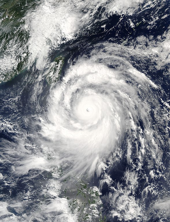
English: Super Typhoon Meranti neared Taiwan on September 13, 2016. The Moderate Resolution Imaging Spectroradiometer (MODIS) on NASA’s Aqua satellite acquired this natural-color image the same day. At the time, Meranti was a category 5 storm with wind speeds of roughly 160 knots (184mph).
Forecasters expect the storm to skirt the southern tip of Taiwan in the morning hours of September 14. The U.S. Navy’s Joint Typhoon Warning Center (JTWC) predicts maximum open-ocean waves of 48 feet and sustained winds of 150 knots (173 miles per hour), with gusts up to 180 knots (207 mph) as Mernati passes Taiwan. While the eye of the storm won’t hit Taiwan directly, the island will take the brunt of the right side of the storm. Meranti is expected to lose some momentum by the time it makes landfall in China’s Guangdong province on September 15, with predicted winds of 80 knots (92 mph) and gusts up to 100 knots (115 mph). The Taiwanese government announced that schools and offices in several municipalities in the south would be closed on Wednesday, according to The Weather Channel. The storm has already caused flight and train delays in the region. |
| Fecha | |
| Fuente | https://lance.modaps.eosdis.nasa.gov/cgi-bin/imagery/single.cgi?image=Meranti.A2016257.0510.250m.jpg |
| Autor | National Aeronautics and Space Administration, LANCE/EOSDIS Rapid Response, captured on Aqua satellite |
| Metadata | http://lance.modaps.eosdis.nasa.gov/cgi-bin/imagery/single.cgi?metadata=Meranti.A2016257.0510.txt |
| Satellite | Aqua |
Licencia
[editar].jpg&action=edit§ion=2)
| Este archivo es de dominio público porque fue creado por la NASA. Las políticas sobre copyright de la NASA estipulan que «el material de la NASA no está protegido con copyright a menos que se indique lo contrario». (Políticas sobre copyright de la NASA o Políticas sobre la utilización de imágenes del Jet Propulsion Laboratory). | ||
 |
Advertencias:
|
Historial del archivo
Haz clic sobre una fecha y hora para ver el archivo tal como apareció en ese momento.
| Fecha y hora | Miniatura | Dimensiones | Usuario | Comentario | |
|---|---|---|---|---|---|
| actual | 04:40 15 sep 2016 | | 7200 × 9400 (9,83 MB) | Nino Marakot (discusión | contribs.) | User created page with UploadWizard |
No puedes sobrescribir este archivo.
Usos del archivo
La siguiente página usa este archivo:
Uso global del archivo
Las wikis siguientes utilizan este archivo:
- Uso en es.wikipedia.org
- Uso en ko.wikipedia.org
- Uso en pt.wikipedia.org
- Uso en tl.wikipedia.org
.jpg&oldid=800295049)