File:Mercury weird terrain.jpg
维基共享资源,媒体文件资料库
跳转到导航
跳转到搜索

本预览的尺寸:677 × 599像素。 其他分辨率:271 × 240像素 | 542 × 480像素 | 783 × 693像素。
原始文件 (783 × 693像素,文件大小:108 KB,MIME类型:image/jpeg)
文件信息
结构化数据
说明
说明
添加一行文字以描述该文件所表现的内容
摘要[编辑]
| 描述Mercury weird terrain.jpg |
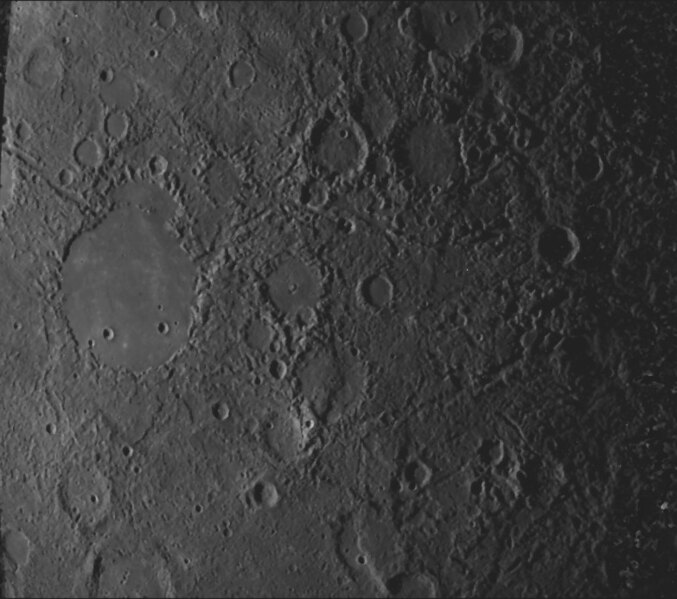
English: Weird terrain best describes this hilly, lineated region of Mercury. Scientists note that this area is at the antipodal point to the large Caloris basin. The shock wave produced by the Caloris impact may have been reflected and focused to the antipodal point, thus jumbling the crust and breaking it into a series of complex blocks. The area covered is about 800 km (497 mi) on a side. The crater at left is now known as Petrarch. This is based on Mariner 10 image 27299. |
| 日期 | |
| 来源 |
Source: http://pds.jpl.nasa.gov/planets/captions/mercury/mercter.htm |
| 作者 | NASA/JPL |
许可协议[编辑]
| Public domainPublic domainfalsefalse |
| 本文件完全由NASA创作,在美国属于公有领域。根据NASA的版权方针,NASA的材料除非另有声明否则不受版权保护。(参见Template:PD-USGov/zh、NASA版权方针页面或JPL图片使用方针。) |  | |
 |
警告:
|
原始上传日志[编辑]
原始描述頁面位於這裡。下列使用者名稱均來自en.wikipedia。
- 2007-03-23 13:24 Deuar 400×368× (62543 bytes) '''Source''': http://pds.jpl.nasa.gov/planets/captions/mercury/mercter.htm (subsequently cropped) Also appears at the NASA Planetary Photojournal: http://photojournal.jpl.nasa.gov/catalog/PIA02445 ''extract from the image's caption:'' Weird terrain bes
文件历史
点击某个日期/时间查看对应时刻的文件。
| 日期/时间 | 缩略图 | 大小 | 用户 | 备注 | |
|---|---|---|---|---|---|
| 当前 | 2020年1月21日 (二) 20:45 |  | 783 × 693(108 KB) | Jstuby(留言 | 贡献) | original image used as source (not upsampled), but brightness and contrast still adjusted. http://ser.sese.asu.edu/M10/IMAGE_ARCHIVE/SingleImage.html?image_number=27299 |
| 2015年12月20日 (日) 06:46 |  | 700 × 645(127 KB) | PlanetUser(留言 | 贡献) | larger | |
| 2010年2月16日 (二) 19:26 |  | 400 × 368(61 KB) | OTAVIO1981(留言 | 贡献) | {{Information |Description={{en|'''Source''': http://pds.jpl.nasa.gov/planets/captions/mercury/mercter.htm (subsequently cropped) Also appears at the NASA Planetary Photojournal: http://photojournal.jpl.nasa.gov/catalog/PIA02445 ''extract from the image |
您不可以覆盖此文件。
文件用途
以下2个页面使用本文件:
全域文件用途
以下其他wiki使用此文件:
- az.wikipedia.org上的用途
- en.wikipedia.org上的用途
- en.wikiversity.org上的用途
- fr.wikipedia.org上的用途
- gl.wikipedia.org上的用途
- mk.wikipedia.org上的用途
- sq.wikipedia.org上的用途
- vi.wikipedia.org上的用途
- zh.wikipedia.org上的用途
元数据
此文件中包含有额外的信息。这些信息可能是由数码相机或扫描仪在创建或数字化过程中所添加。
如果文件已从其原始状态修改,某些细节可能无法完全反映修改后的文件。
| JPEG文件备注 | Handmade Software, Inc. Image Alchemy v1.7.2 |
|---|