File:Meyers b14 s0300a.jpg
跳至導覽
跳至搜尋

預覽大小:375 × 600 像素。 其他解析度:150 × 240 像素 | 300 × 480 像素。
原始檔案 (800 × 1,280 像素,檔案大小:376 KB,MIME 類型:image/jpeg)
說明
說明
添加單行說明來描述出檔案所代表的內容
摘要
[編輯]
| 描述 |
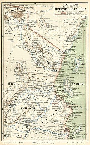
Deutsch: Karte von Sansibar und Deutsch-Ostafrika (Tansania) c. 1890, mit Kilimandscharo ("KILIMA-NDSCHARO"). Auch, Mombasa in Britisch-Ostafrika (Kenya).
English: German map of Zanzibar and German East Africa (Tanzania) c. 1890, with Mount Kilimanjaro ("KILIMA-NDSCHARO"). Also, Mombasa in British East Africa (Kenya). |
|||||
| 日期 | 在1885年到1890年之間 | |||||
| 來源 | Meyers Konversations-Lexikon, 4th Auflage, Band 14, Seite 300a (4th ed., Vol. 14, p.300a) | |||||
| 作者 | Bibliographisches Institut, in Leipzig | |||||
| 授權許可 (重用此檔案) |
|
|||||
| 其他版本 | Derivative works of this file: Taveta 1890.jpg |
授權條款
[編輯]
| This image comes from the 4th edition of Meyers Konversationslexikon (1885–90). The copyrights have expired and this image is in the public domain. |
|
本作品在其來源國以及其他著作權期限是作者逝世後100年或以下的國家與地區屬於公有領域。 | |
| 此作品無已知的著作權限制,亦不受所有相關和鄰接的權利限制。 | |
檔案歷史
點選日期/時間以檢視該時間的檔案版本。
| 日期/時間 | 縮圖 | 尺寸 | 使用者 | 備註 | |
|---|---|---|---|---|---|
| 目前 | 2007年8月24日 (五) 15:34 | | 800 × 1,280(376 KB) | Red Rooster(留言 | 貢獻) | {{Information |Description={{PD-Meyers-pages|14}} |Source=http://susi.e-technik.uni-ulm.de:8080/Meyers2/index/index.html |Date= |Author= |Permission=Author died more than 70 years ago - public domain |other_versions= }} {{PD-old}} |
無法覆蓋此檔案。
檔案用途
下列5個頁面有用到此檔案:
全域檔案使用狀況
以下其他 wiki 使用了這個檔案:
- ar.wikipedia.org 的使用狀況
- as.wikipedia.org 的使用狀況
- azb.wikipedia.org 的使用狀況
- ca.wikipedia.org 的使用狀況
- cs.wikipedia.org 的使用狀況
- de.wikipedia.org 的使用狀況
- de.wikisource.org 的使用狀況
- el.wikipedia.org 的使用狀況
- en.wikipedia.org 的使用狀況
- eo.wikipedia.org 的使用狀況
- es.wikipedia.org 的使用狀況
- eu.wikipedia.org 的使用狀況
- fr.wikipedia.org 的使用狀況
- gl.wikipedia.org 的使用狀況
- he.wikipedia.org 的使用狀況
- hi.wikipedia.org 的使用狀況
- hr.wikipedia.org 的使用狀況
- hu.wikipedia.org 的使用狀況
- hy.wikipedia.org 的使用狀況
- id.wikipedia.org 的使用狀況
- ilo.wikipedia.org 的使用狀況
- it.wikipedia.org 的使用狀況
檢視此檔案的更多全域使用狀況。
詮釋資料
分類:
- MKL - Complete pages: Book 14
- 1890 maps of Africa
- Maps of German East Africa
- Maps of British East Africa
- Old maps of Kenya
- Old maps of Zanzibar
- 19th-century maps of Tanzania
- History of East Africa
- Maps from Meyers Konversationslexikon 4th edition
- Old maps of Mombasa
- Maps with a scale of 1:3,000,000
- 1880s maps of Africa