File:Middle East map of Köppen climate classification.svg
Aller à la navigation
Aller à la recherche

Taille de cet aperçu PNG pour ce fichier SVG : 600 × 600 pixels. Autres résolutions : 240 × 240 pixels | 480 × 480 pixels | 768 × 768 pixels | 1 024 × 1 024 pixels | 2 048 × 2 048 pixels | 1 900 × 1 900 pixels.
Fichier d’origine (Fichier SVG, nominalement de 1 900 × 1 900 pixels, taille : 456 kio)
Légendes
Légendes
Ajoutez en une ligne la description de ce que représente ce fichier
Description
[modifier]| Description |
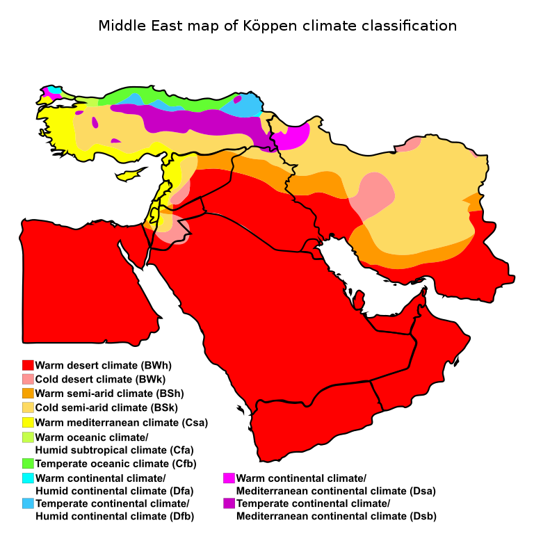
English: Middle East map of Köppen climate classification |
||||||||||
| Date | |||||||||||
| Source |
|
||||||||||
| Auteur |
|
||||||||||
| Autres versions |
|
.svg)


_map_of_K%C3%B6ppen_climate_classification.svg)


.svg)
.svg)
.svg)
.svg)
.svg)
.svg)
.svg)
.svg)
.svg)
.svg)
.svg)
.svg)
.svg)
.svg)
.svg)
.svg)
.svg)
.svg)
.svg)
.svg)
.svg)
.svg)
.svg)
.svg)
.svg)
.svg)
Conditions d’utilisation
[modifier]
Moi, en tant que détenteur des droits d’auteur sur cette œuvre, je la publie sous la licence suivante :
Ce fichier est sous la licence Creative Commons Attribution – Partage dans les Mêmes Conditions 4.0 International.
- Vous êtes libre :
- de partager – de copier, distribuer et transmettre cette œuvre
- d’adapter – de modifier cette œuvre
- Sous les conditions suivantes :
- paternité – Vous devez donner les informations appropriées concernant l'auteur, fournir un lien vers la licence et indiquer si des modifications ont été faites. Vous pouvez faire cela par tout moyen raisonnable, mais en aucune façon suggérant que l’auteur vous soutient ou approuve l’utilisation que vous en faites.
- partage à l’identique – Si vous modifiez, transformez, ou vous basez sur cette œuvre, vous devez distribuer votre contribution sous la même licence ou une licence compatible avec celle de l’original.
Historique du fichier
Cliquer sur une date et heure pour voir le fichier tel qu'il était à ce moment-là.
| Date et heure | Vignette | Dimensions | Utilisateur | Commentaire | |
|---|---|---|---|---|---|
| actuel | 21 février 2016 à 02:22 | | 1 900 × 1 900 (456 kio) | Oganesson007 (d | contributions) | User created page with UploadWizard |
Vous ne pouvez pas remplacer ce fichier.
Utilisations locales du fichier
Plus de 100 pages utilisent ce fichier. La liste suivante affiche seulement les 100 premières pages qui utilisent ce fichier. Une liste complète est disponible.
- File:Afghanistan map of Köppen climate classification.svg
- File:Albania map of Köppen climate classification.svg
- File:Algeria map of Köppen climate classification.svg
- File:Angola map of Köppen climate classification.svg
- File:Argentina map of Köppen climate classification.svg
- File:Armenia map of Köppen climate classification.svg
- File:Australia map of Köppen climate classification.svg
- File:Austria map of Köppen climate classification.svg
- File:Azerbaijan map of Köppen climate classification.svg
- File:Bangladesh map of Köppen climate classification.svg
- File:Belize map of Köppen climate classification.svg
- File:Benin map of Köppen climate classification.svg
- File:Bhutan map of Köppen climate classification.svg
- File:Bolivia map of Köppen climate classification.svg
- File:Bosnia and Herzegovina map of Köppen climate classification.svg
- File:Botswana map of Köppen climate classification.svg
- File:Brazil map of Köppen climate classification.svg
- File:Bulgaria map of Köppen climate classification.svg
- File:Burkina Faso map of Köppen climate classification.svg
- File:Cambodia map of Köppen climate classification.svg
- File:Cameroon map of Köppen climate classification.svg
- File:Canada map of Köppen climate classification.svg
- File:Central African Republic map of Köppen climate classification.svg
- File:Chad map of Köppen climate classification.svg
- File:Chile map of Köppen climate classification.svg
- File:China map of Köppen climate classification.svg
- File:Colombia map of Köppen climate classification.svg
- File:Costa Rica map of Köppen climate classification.svg
- File:Czech Republic map of Köppen climate classification.svg
- File:Côte d’Ivoire map of Köppen climate classification.svg
- File:Democratic Republic of the Congo map of Köppen climate classification.svg
- File:Denmark map of Köppen climate classification.svg
- File:Dominican Republic map of Köppen climate classification.svg
- File:Ecuador map of Köppen climate classification.svg
- File:Eritrea map of Köppen climate classification.svg
- File:Ethiopia map of Köppen climate classification.svg
- File:Finland map of Köppen climate classification.svg
- File:France map of Köppen climate classification.svg
- File:Gabon map of Köppen climate classification.svg
- File:Georgia map of Köppen climate classification.svg
- File:Germany map of Köppen climate classification.svg
- File:Ghana map of Köppen climate classification.svg
- File:Greece map of Köppen climate classification.svg
- File:Greenland map of Köppen climate classification.svg
- File:Guatemala map of Köppen climate classification.svg
- File:Guniea map of Köppen climate classification.svg
- File:Guyana map of Köppen climate classification.svg
- File:Honduras map of Köppen climate classification.svg
- File:Hungary map of Köppen climate classification.svg
- File:Iceland map of Köppen climate classification.svg
- File:India map of Köppen climate classification.svg
- File:Indonesia map of Köppen climate classification.svg
- File:Iran map of Köppen climate classification.svg
- File:Iraq map of Köppen climate classification.svg
- File:Israel map of Köppen climate classification.svg
- File:Italy map of Köppen climate classification.svg
- File:Japan map of Köppen climate classification.svg
- File:Jordan map of Köppen climate classification.svg
- File:Kazakhstan map of Köppen climate classification.svg
- File:Kenya map of Köppen climate classification.svg
- File:Kyrgyzstan map of Köppen climate classification.svg
- File:Laos map of Köppen climate classification.svg
- File:Liberia map of Köppen climate classification.svg
- File:Libya map of Köppen climate classification.svg
- File:Madagascar map of Köppen climate classification.svg
- File:Malaysia map of Köppen climate classification.svg
- File:Mali map of Köppen climate classification.svg
- File:Mauritania map of Köppen climate classification.svg
- File:Mexico map of Köppen climate classification.svg
- File:Mongolia map of Köppen climate classification.svg
- File:Morocco map of Köppen climate classification.svg
- File:Mozambique map of Köppen climate classification.svg
- File:Myanmar (Burma) map of Köppen climate classification.svg
- File:Namibia map of Köppen climate classification.svg
- File:Nepal map of Köppen climate classification.svg
- File:Nicaragua map of Köppen climate classification.svg
- File:Niger map of Köppen climate classification.svg
- File:Nigeria map of Köppen climate classification.svg
- File:North Korea map of Köppen climate classification.svg
- File:Norway map of Köppen climate classification.svg
- File:Pakistan map of Köppen climate classification.svg
- File:Panama map of Köppen climate classification.svg
- File:Papua New Guinea map of Köppen climate classification.svg
- File:Paraguay map of Köppen climate classification.svg
- File:Peru map of Köppen climate classification.svg
- File:Philippines map of Köppen climate classification.svg
- File:Portugal map of Köppen climate classification.svg
- File:Republic of the Congo map of Köppen climate classification.svg
- File:Romania map of Köppen climate classification.svg
- File:Senegal map of Köppen climate classification.svg
- File:Serbia map of Köppen climate classification.svg
- File:Sierra Leone map of Köppen climate classification.svg
- File:Slovakia map of Köppen climate classification.svg
- File:Somalia map of Köppen climate classification.svg
- File:South Africa map of Köppen climate classification.svg
- File:South Korea map of Köppen climate classification.svg
- File:South Sudan map of Köppen climate classification.svg
- File:Spain map of Köppen climate classification.svg
- File:Sri Lanka map of Köppen climate classification.svg
- File:Sudan map of Köppen climate classification.svg
Voir plus de liens vers ce fichier.
Utilisations du fichier sur d’autres wikis
Les autres wikis suivants utilisent ce fichier :
- Utilisation sur af.wikipedia.org
- Utilisation sur arz.wikipedia.org
- Utilisation sur ast.wikipedia.org
- Utilisation sur bcl.wikipedia.org
- Utilisation sur bn.wikipedia.org
- Utilisation sur crh.wikipedia.org
- Utilisation sur el.wikipedia.org
- Utilisation sur en.wikipedia.org
- Utilisation sur es.wikipedia.org
- Utilisation sur fa.wikipedia.org
- Utilisation sur fr.wikipedia.org
- Utilisation sur ha.wikipedia.org
- Utilisation sur he.wikipedia.org
- Utilisation sur id.wikipedia.org
- Utilisation sur mk.wikipedia.org
- Utilisation sur my.wikipedia.org
- Utilisation sur nn.wikipedia.org
- Utilisation sur ro.wikipedia.org
- Utilisation sur te.wikipedia.org
- Utilisation sur th.wikipedia.org
- Utilisation sur tr.wikipedia.org
- Utilisation sur ur.wikipedia.org
- Utilisation sur zh.wikipedia.org