File:Migriggyangzham Co and Dorsoidong Co.jpg
跳去導覽
跳去搵嘢

預覽大細:800 × 438 像素。 第啲解像度:320 × 175 像素 | 640 × 351 像素 | 1,040 × 570 像素。
原本檔案 (1,040 × 570 像素,檔案大細:174 KB ,MIME類型:image/jpeg)
Captions
Captions
Add a one-line explanation of what this file represents
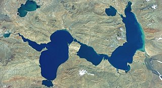
Lakes Migriggyangzham Co (Chibzhang Co) and Dorsoidong Co in west of China
摘要
[編輯]| 描述 |
Русский: Мигриггъянгджам-Цо (к востоку) и Дорсёдонг-Цо (к западу) образуют водную систему. Ранее была известна как Чибчанг или Чибчанг-Цо. Питание от ледников. Небольшое озеро в верхнем левом углу снимка гидрологически никак не связано с этой водной системой, относится к другому водосборному бассейну
English: Lakes Migriggyangzham Co (east, right) and Dorsoidong Co (west, left). |
| 日期 | 未知日期 |
| 來源 | Screenshot from NASA World Wind software, Blue Marble & Landsat layer |
| 作者 | NASA |
| Other versions |


| Object location | | View this and other nearby images on: OpenStreetMap |
|---|
協議
[編輯]
| This image is in the public domain because it is a screenshot from NASA’s globe software World Wind using a public domain layer, such as Blue Marble, MODIS, Landsat, SRTM, USGS or GLOBE.
|
 |
檔案歷史
撳個日期/時間去睇響嗰個時間出現過嘅檔案。
| 日期/時間 | 縮圖 | 尺寸 | 用戶 | 註解 | |
|---|---|---|---|---|---|
| 現時 | 2022年2月17號 (四) 09:37 | | 1,040 × 570(174 KB) | Proeksad(傾偈 | 貢獻) | Uploaded a work by NASA from Screenshot from NASA World Wind software, Blue Marble & Landsat layer with UploadWizard |
你無得衾咗個檔案。
檔案用途
以下嘅2版用到呢個檔:
全域檔案使用情況
下面嘅維基都用緊呢個檔案:
- ru.wikipedia.org嘅使用情況