File:Mitteleuropa ENG wielgórski.PNG
跳转到导航
跳转到搜索
本预览的尺寸:436 × 600像素。 其他分辨率:174 × 240像素 | 349 × 480像素 | 779 × 1,072像素。
原始文件 (779 × 1,072像素,文件大小:212 KB,MIME类型:image/png)
说明
说明
添加一行文字以描述该文件所表现的内容
| 描述 |
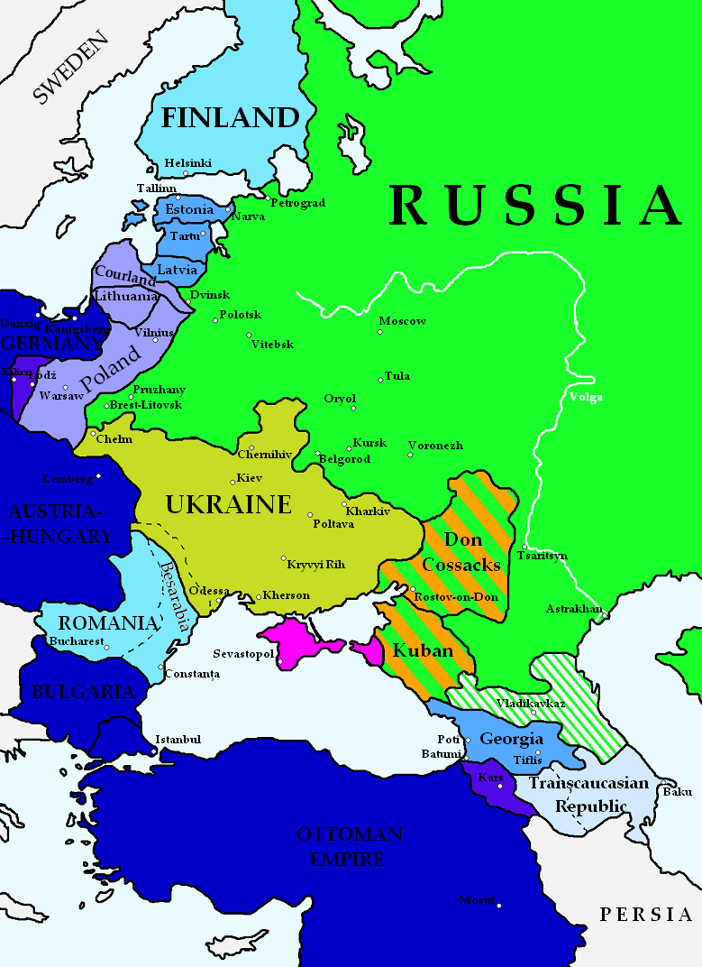
English: Map of German plans for a new political order in Central and Eastern Europe ("The Mitteleuropa Plan") after the Treaty of Brest-Litovsk of February 9th, 1918, Treaty of Brest-Litovsk of March 3rd, 1918 and Treaty of Bucharest of May 7th, 1918.
Polski: Mapa przedstawiająca niemieckie plany polityczne wobec Europy Środkowej i Wschodniej (koncepcja "Mitteleuropy") po Traktacie brzeskim z 9 lutego 1918, Traktacie brzeskim z 3 marca 1918 i Traktacie bukaresztańskim z 7 maja 1918.
English (en):
Germany and its allies Part of Poland and Armenia to be annexed by Germany/Turkey Semiautonomous states under full German control - planned annexation New countries - economically and administratively dependent of Germany Ukraine - under German economic control Planned Tatar Republic - area of German colonization Countries politically and economically tied with Germany Planned Transcaucasian Republic - politically tied with Germany Semiautonomous Cossack states inside Russia - German sphere of influence
polski (pl):
Niemcy i ich sojusznicy Część Polski i Armenii przeznaczona do aneksji przez Niemcy/Turcję Półautonomiczne państwa pod kontrolą Niemiec - w przyszłości planowana aneksja Państwa gospodarczo i administracyjnie zależne od Niemiec Ukraina - pod ekonomiczną kontrolą Niemiec Planowana Republika Tatarska - niemiecki obszar osiedleńczy Państwa politycznie i gospodarczo związane z Niemcami Planowana Republika Zakaukaska - politycznie związana z Niemcami Półautonomiczne państwa kozackie wewnątrz Rosji - niemiecka strefa wpływów
Based on:
|
| 日期 | |
| 来源 | 自己的作品 |
| 作者 | Robert Wielgórski |
| 其他版本 |
|


![[1]](https://pl.wikipedia.org/wiki/Plik:Armisticebrestlitovsk.jpg)
![[2]](https://en.wikipedia.org/wiki/File:Dismembered_Russia_%E2%80%94_Some_Fragments_%28NYT_article,_Feb._17,_1918%29.png)
许可协议
[编辑]
我,本作品著作权人,特此采用以下许可协议发表本作品:

|
已授权您依据自由软件基金会发行的无固定段落及封面封底文字(Invariant Sections, Front-Cover Texts, and Back-Cover Texts)的GNU自由文件许可协议1.2版或任意后续版本的条款,复制、传播和/或修改本文件。该协议的副本请见“GNU Free Documentation License”。 |
| 本文件采用知识共享署名-相同方式共享 3.0 未本地化版本许可协议授权。 | ||
| ||
| 本许可协议标签作为GFDL许可协议更新的组成部分被添加至本文件。 |
您可以选择您需要的许可协议。
文件历史
点击某个日期/时间查看对应时刻的文件。
| 日期/时间 | 缩略图 | 大小 | 用户 | 备注 | |
|---|---|---|---|---|---|
| 当前 | 2010年2月21日 (日) 22:40 | | 779 × 1,072(212 KB) | Barry Kent~commonswiki(留言 | 贡献) | {{Information |Description= {{En|Map of German plans for a new political order in Central and Eastern Europe ("The Mitteleuropa Plan") after the [[:en:Treaty_of_Brest-Litovsk_(February_9,_1918)|Treaty of Brest-Litovsk of February 9th, |
您不可以覆盖此文件。
文件用途
以下4个页面使用本文件:
全域文件用途
以下其他wiki使用此文件:
- en.wikipedia.org上的用途
- es.wikipedia.org上的用途
- it.wikipedia.org上的用途
- ru.wikipedia.org上的用途
- uk.wikipedia.org上的用途
- zh.wikipedia.org上的用途