File:Molotov-Ribbentrop Pact showing the new German-Soviet border Sept 28 1939.png

De Wikimedia Commons
Salta a la navegació Salta a la cerca

Fitxer original(1.505 × 1.999 píxels, mida del fitxer: 630 Ko, tipus MIME: image/png)
Llegendes

Llegendes

Afegeix una explicació d'una línia del que representa aquest fitxer

Resum

[modifica]
Descripció
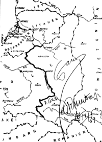
Deutsch: Karte aus dem geheimen Zusatzprotokolls des Deutsch-sowjetischen Nichtangriffspakts, der die vorgesehene Teilung Polens zeigt. Die Karte ist unterschrieben von Josef Stalin und Reichsaußenminister Joachim von Ribbentrop.
English: The map from the secret appendix to the Molotov-Ribbentrop Pact showing the new German-Soviet border. The map is signed by Joseph Stalin and German Foreign Minister Joachim von Ribbentrop. Note Stalin's signature on the border correction east of Rzeszow and south of Zamosc. Note: Genuine photo is color.
Data (document), 1946 (photo)
Font This photo of the document was made in 1946 by the defence of von Ribbentrop and Hermann Göring in the Nuremberg Trials in 1946.
Autor DesconegutUnknown author
Permís
(Com reutilitzar aquest fitxer)
Public domain
Altres versions

Llicència

[modifica]
Public domain
This file is in the public domain because This is a German photograph now well over 50 years old. Under Germany's copyright law, Article 72, this means that any copyright has expired.

This template must not be used to dedicate an uploader's own work to the public domain; CC0 should be used instead.

This work must carry justifications for free usability in both the United States and its country of origin.

Historial del fitxer

Cliqueu una data/hora per veure el fitxer tal com era aleshores.

Data/horaMiniaturaDimensionsUsuari/aComentari
actual11:58, 28 maig 2009Miniatura per a la versió del 11:58, 28 maig 20091.505 × 1.999 (630 Ko)Esemono (discussió | contribucions)== Summary == {{Information |Description= {{de|Karte aus dem geheimen Zusatzprotokolls des Deutsch-sowjetischen Nichtangriffspakts, der die vorgesehene Teilung Polens zeigt. Die Karte ist unterschrieben von [

Ús global del fitxer

Utilització d'aquest fitxer en altres wikis: