File:Morocco (orthographic projection).svg
跳至導覽
跳至搜尋

此 SVG 檔案的 PNG 預覽的大小:550 × 550 像素。 其他解析度:240 × 240 像素 | 480 × 480 像素 | 768 × 768 像素 | 1,024 × 1,024 像素 | 2,048 × 2,048 像素。
原始檔案 (SVG 檔案,表面大小:550 × 550 像素,檔案大小:307 KB)
說明
說明
添加單行說明來描述出檔案所代表的內容
Sahara marocain
摘要
[編輯]
| 描述 |
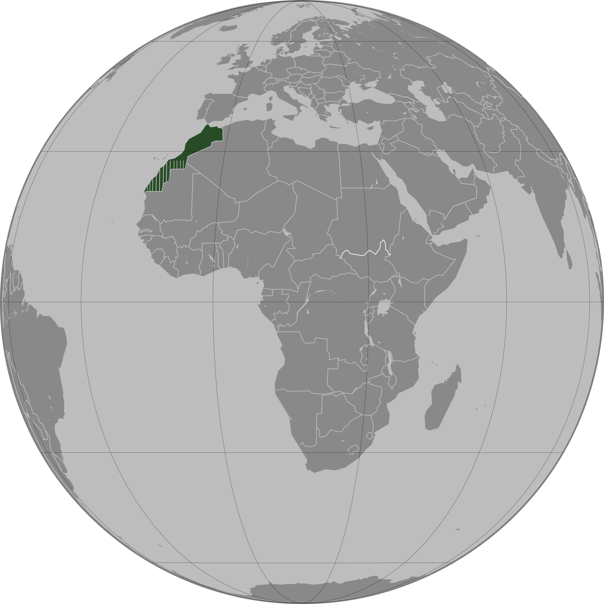
العربية: تحديد المغرب مع إقليمه المتنازع عليه الصحراء المغربية بشكل مخطط، الأمم المتحدة تعترف بصحراء المغرب.
Español: Localización de Marruecos y del territorio ocupado del Sahara Occidental. Ni las Naciones Unidas ni nungún país del mundo reconoce a Marruecos la soberanía sobre dicho territorio, que a ojos de la Comunidad Internacional sigue siendo considerado un Territorio No Autónomo pendiente de descolonización como así lo corrobora el informe S/2002/161.
Français : Localisation du Maroc et de son territoire contesté Sahara occidental, en pointillés. Les Nations Unies reconnaissent au Maroc la souveraineté administrative sur ce territoire.
Deutsch: Lokalisierung Marokkos und seines strittigen Territoriums Westsahara, gestrichelt dargestellt. Die Vereinten Nationen gestehen Marokko Verwaltungshoheit über das Territorium zu.
English: Locator of Morocco and the disputed territory Western Sahara shown as striped. United Nations recognize Morocco as an administrative power of the territory.
Português: Localização de Marrocos e do seu território contestado Saara Ocidental, tracejado. As Nações Unidas concedem a Marrocos a soberania administrativa sobre esse território. |
||||
| 日期 | |||||
| 來源 |
自己的作品
|
||||
| 作者 | Flad | ||||
| 其他版本 |
|
.svg)
.svg)
.svg)
.svg)
_highlighted.svg)
.svg&action=edit§ion=1)
.svg)
والمغرب في صحرائه وصحراء في مغربها
授權條款
[編輯].svg&action=edit§ion=2)

|
已授權您依據自由軟體基金會發行的無固定段落、封面文字和封底文字GNU自由文件授權條款1.2版或任意後續版本,對本檔進行複製、傳播和/或修改。該協議的副本列在GNU自由文件授權條款中。 |
| 此檔案採用創用CC 姓名標示-相同方式分享 3.0 未在地化版本授權條款。 | ||
| ||
| 已新增授權條款標題至此檔案,作為GFDL授權更新的一部份。 |
檔案歷史
點選日期/時間以檢視該時間的檔案版本。
.svg&uselang=zh-tw&dir=prev)
.svg&uselang=zh-tw&offset=20110503163341)
.svg&uselang=zh-tw&offset=&limit=20)
.svg&uselang=zh-tw&offset=&limit=50)
.svg&uselang=zh-tw&offset=&limit=100)
.svg&uselang=zh-tw&offset=&limit=250)
.svg&uselang=zh-tw&offset=&limit=500)
| 日期/時間 | 縮圖 | 尺寸 | 使用者 | 備註 | |
|---|---|---|---|---|---|
| 目前 | 2011年8月13日 (六) 04:40 | | 550 × 550(307 KB) | Banhtrung1(留言 | 貢獻) | Added the South Sudan. |
| 2011年5月9日 (一) 19:30 |  | 550 × 550(292 KB) | Omar-Toons(留言 | 貢獻) | please read the description + consensus that this is the right version to be shared under this name | |
| 2011年5月9日 (一) 19:28 |  | 550 × 550(293 KB) | Eddo(留言 | 貢獻) | User talk:Omar-Toons | |
| 2011年5月9日 (一) 16:22 |  | 550 × 550(292 KB) | Omar-Toons(留言 | 貢獻) | Reverted to version as of 13:04, 8 May 2011 please read the description | |
| 2011年5月9日 (一) 06:25 |  | 550 × 550(293 KB) | Eddo(留言 | 貢獻) | Reverted to version as of 07:11, 8 May 2011 | |
| 2011年5月8日 (日) 13:04 |  | 550 × 550(292 KB) | Rekaf(留言 | 貢獻) | Reverted to version as of 00:02, 6 July 2010 -- the original file is already striped, you can upload a new version with light-green | |
| 2011年5月8日 (日) 07:11 |  | 550 × 550(293 KB) | Eddo(留言 | 貢獻) | West Sahara is not part of Morocco | |
| 2011年5月6日 (五) 08:15 |  | 550 × 550(292 KB) | Omar-Toons(留言 | 貢獻) | Reverted to version as of 16:33, 3 May 2011 Another version (WS excluded) exists. Reverting non-consensual change | |
| 2011年5月3日 (二) 18:01 |  | 550 × 550(293 KB) | Eddo(留言 | 貢獻) | Redrawing the border between Morocco and West Sahara, please don't erase it | |
| 2011年5月3日 (二) 16:33 |  | 550 × 550(292 KB) | Flad(留言 | 貢獻) | Reverted to version as of 00:02, 6 July 2010 |
無法覆蓋此檔案。
檔案用途
下列8個頁面有用到此檔案:
- Locator maps of countries of Africa
- ⴰⵎⵓⵔ ⵏ ⵡⴰⴽⵓⵛ / Morocco / المغرب
- User:Sette-quattro/Sandbox
- Commons:Graphic Lab/Map workshop/Archive/2010
- File:Morocco (orthographic projection).svg
- File:Morocco WS-excluded (orthographic projection).svg
- File:Morocco and Western Sahara (orthographic projection).svg
- Category:Morocco by topic
全域檔案使用狀況
以下其他 wiki 使用了這個檔案:
- ar.wikipedia.org 的使用狀況
- ca.wikipedia.org 的使用狀況
- da.wikipedia.org 的使用狀況
- en.wikipedia.org 的使用狀況
- en.wikinews.org 的使用狀況
- es.wikipedia.org 的使用狀況
- fr.wikipedia.org 的使用狀況
- fr.wikinews.org 的使用狀況
- incubator.wikimedia.org 的使用狀況
- nap.wikipedia.org 的使用狀況
- tr.wikipedia.org 的使用狀況
.svg&oldid=891867829)