File:Moskau1941vonLuckJackroma.jpg
跳转到导航
跳转到搜索
本预览的尺寸:436 × 600像素。 其他分辨率:174 × 240像素 | 349 × 480像素 | 558 × 768像素 | 744 × 1,024像素 | 2,550 × 3,509像素。
原始文件 (2,550 × 3,509像素,文件大小:9.38 MB,MIME类型:image/jpeg)
说明
说明
添加一行文字以描述该文件所表现的内容
摘要
[编辑]
| 描述 |
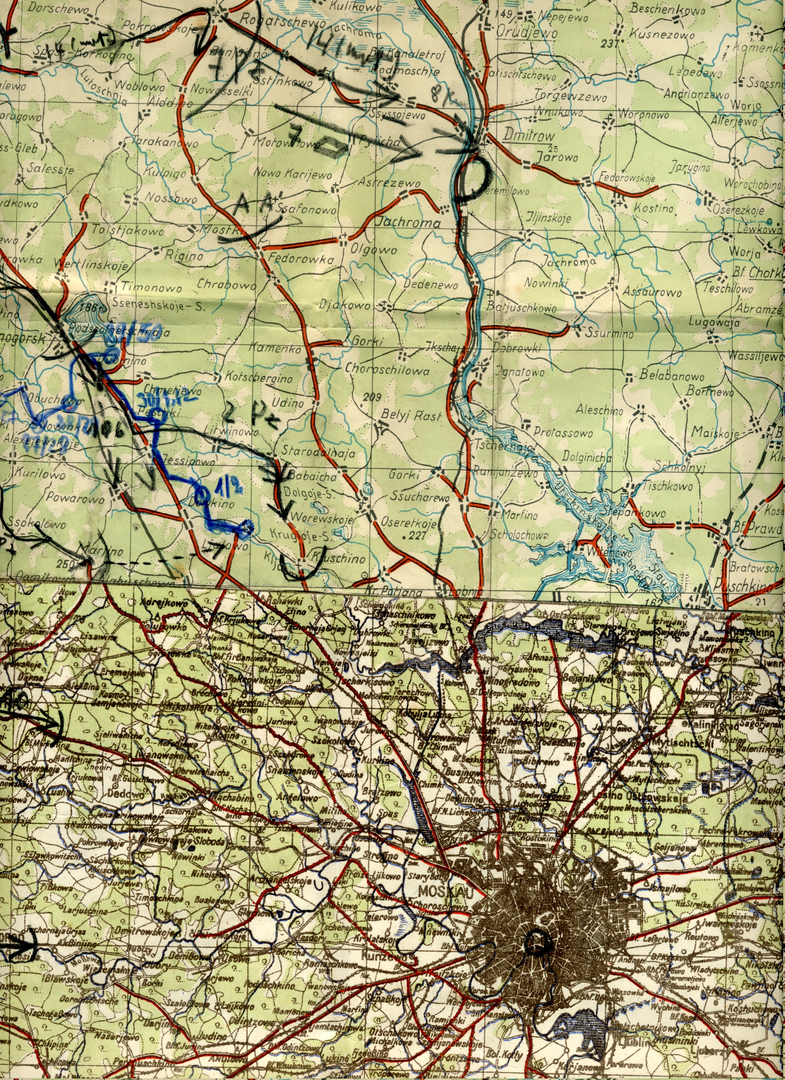
English: This is the map Hans von Luck used during the advance on Moscow [Moskau] during
World War Two WWII [WK2]. It details the limit of his advance to a small village called Jachroma. Von Luck gives an account of this advance in his memoirs "Panzer Commander". The maps shows the furthest advance of the German Army [Heer] toward Moscow. The map was constructed from several German maps which were joined together. |
| 日期 | |
| 来源 | 自己的作品 |
| 作者 | ArminWenger |
许可协议
[编辑]
| 我,本作品著作权人,释出本作品至公有领域。这适用于全世界。 在一些国家这可能不合法;如果是这样的话,那么: 我无条件地授予任何人以任何目的使用本作品的权利,除非这些条件是法律规定所必需的。 |
文件历史
点击某个日期/时间查看对应时刻的文件。
| 日期/时间 | 缩略图 | 大小 | 用户 | 备注 | |
|---|---|---|---|---|---|
| 当前 | 2009年2月1日 (日) 13:24 | | 2,550 × 3,509(9.38 MB) | ArminWenger(留言 | 贡献) | {{Information |Description={{en|1= This is the map Hans von Luck used during the advance on Moscow [Moskau] during World War Two WWII [WK2]. It details the limit of his advance to a small village called Jachroma. Von Luck gives an account of this adv |
您不可以覆盖此文件。
文件用途
没有页面使用本文件。
全域文件用途
以下其他wiki使用此文件:
- ar.wikipedia.org上的用途
- ca.wikipedia.org上的用途
- en.wikipedia.org上的用途
- es.wikipedia.org上的用途
- fi.wikipedia.org上的用途
- ja.wikipedia.org上的用途
- pt.wikipedia.org上的用途
- tr.wikipedia.org上的用途
- zh.wikipedia.org上的用途