File:Munster Tabula Novarum Insularum 1540 UTA.jpg

Originaldatei (3.674 × 2.835 Pixel, Dateigröße: 1,93 MB, MIME-Typ: image/jpeg)
Bildtexte
Kurzbeschreibungen
Beschreibung
[Bearbeiten]| Titel |
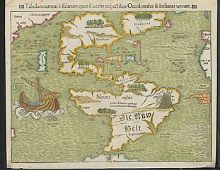
Latina: Tabula Novarum Insularum |
||||||||||||||||||||||||||
| Beschreibung |
English: Religion and politics are often closely allied, and this was especially the case in the sixteenth century. In this famous map, the Spanish flag flies prominently in the West Indies, while the Portuguese flag dominates the south Atlantic – reflecting pronouncements by Pope Alexander VI in 1493 and the Treaty of Tordesillas between Spain and Portugal of 1494. These declarations divided the non-Christian world between the two countries and charged the Portuguese and Spanish rulers with the responsibility of bringing the non-Christian inhabitants into the Catholic faith. This is reputedly the first printed map to name the Pacific Ocean and it is also among the earliest printed maps of the Western Hemisphere to show North and South America as separate but connected landmasses. The map’s creator, Münster, was a German Catholic Franciscan theologian and priest (ordained in 1512) as well as cartographer, cosmographer, humanist, mathematician, and scholar. |
||||||||||||||||||||||||||
| Datum | |||||||||||||||||||||||||||
| Quelle | UTA Libraries Cartographic Connections: Karte / Text | ||||||||||||||||||||||||||
| Urheber |
|
||||||||||||||||||||||||||
| Anerkennung |
English: UTA Libraries Special Collections |
||||||||||||||||||||||||||
| Kartografische Angaben | |||||||||||||||||||||||||||
| Ortsbezug | Amerika | ||||||||||||||||||||||||||
| Georeferenzierung | If inappropriate please set warp_status = skip to hide. | ||||||||||||||||||||||||||
| Bibliographische Angaben | |||||||||||||||||||||||||||
| Publikation |
Geographia Universalis |
||||||||||||||||||||||||||
| Urheber |
|
||||||||||||||||||||||||||
| Erscheinungsort | Basel | ||||||||||||||||||||||||||
| Drucker |
|
||||||||||||||||||||||||||
| Archivalische Angaben | |||||||||||||||||||||||||||
| Sammlung |
|
||||||||||||||||||||||||||
| Maße | Höhe: 27,5 cm; Breite: 34,5 cm | ||||||||||||||||||||||||||
| Technik | kolorierter Stich auf Papier | ||||||||||||||||||||||||||
| artwork-references |
Burden The Mapping of North America, Nr. 12 , S. 15−17 Martin und Martin Maps of Texas and the Southwest, 1513-1900, Nr. 2 , S. 67 |
||||||||||||||||||||||||||
.jpg)

Lizenz
[Bearbeiten]

|
This file was provided to Wikimedia Commons by the University of Texas at Arlington Libraries as part of a cooperation project. The University of Texas at Arlington Libraries is part of the University of Texas at Arlington, a public research university located in Arlington, Texas.
|
|
Der Urheber dieses Werks ist 1552 gestorben; es ist daher gemeinfrei, weil seine urheberrechtliche Schutzfrist abgelaufen ist. Dieses Werk ist gemeinfrei in den Vereinigten Staaten, weil es vor dem 1. Januar 1929 veröffentlicht (oder beim U.S. Copyright Office registriert) wurde. | |
| Es wurde festgestellt, dass diese Datei frei von bekannten Beschränkungen durch das Urheberrecht ist, alle verbundenen und verwandten Rechte eingeschlossen. | |
Dateiversionen
Klicke auf einen Zeitpunkt, um diese Version zu laden.
| Version vom | Vorschaubild | Maße | Benutzer | Kommentar | |
|---|---|---|---|---|---|
| aktuell | 18:23, 29. Jan. 2022 | | 3.674 × 2.835 (1,93 MB) | Michael Barera (Diskussion | Beiträge) | == {{int:filedesc}} == {{Map |title = {{la|'''''Tabula Novarum Insularum'''''}} |description = {{en|Religion and politics are often closely allied, and this was especially the case in the sixteenth century. In this famous map, the Spanish flag flies prominently in the West Indies, while the Portuguese flag dominates the south Atlantic – reflecting pronouncements by Pope Alexander VI in 1493 and the Treaty of Tordesillas between Spain and Portugal of 1494. These declaration... |
Du kannst diese Datei nicht überschreiben.
Dateiverwendung
Die folgende Seite verwendet diese Datei:
Globale Dateiverwendung
Die nachfolgenden anderen Wikis verwenden diese Datei:
- Verwendung auf bg.wikipedia.org
- Verwendung auf de.wikipedia.org
- Verwendung auf el.wikipedia.org
- Verwendung auf en.wikipedia.org
- Verwendung auf es.wikipedia.org
- Verwendung auf eu.wikipedia.org
- Verwendung auf fr.wikipedia.org
- Verwendung auf it.wikipedia.org
- Verwendung auf ru.wikipedia.org