File:Munster Tabula Novarum Insularum 1540 UTA.jpg

Πρωτότυπο αρχείο (3.674 × 2.835 εικονοστοιχεία, μέγεθος αρχείου: 1,93 MB, τύπος MIME: image/jpeg)
Λεζάντες
Λεζάντες
Σύνοψη[επεξεργασία]
| Τίτλος |
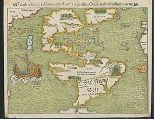
Latina: Tabula Novarum Insularum |
||||||||||||||||||||||||||
| Περιγραφή |
English: Religion and politics are often closely allied, and this was especially the case in the sixteenth century. In this famous map, the Spanish flag flies prominently in the West Indies, while the Portuguese flag dominates the south Atlantic – reflecting pronouncements by Pope Alexander VI in 1493 and the Treaty of Tordesillas between Spain and Portugal of 1494. These declarations divided the non-Christian world between the two countries and charged the Portuguese and Spanish rulers with the responsibility of bringing the non-Christian inhabitants into the Catholic faith. This is reputedly the first printed map to name the Pacific Ocean and it is also among the earliest printed maps of the Western Hemisphere to show North and South America as separate but connected landmasses. The map’s creator, Münster, was a German Catholic Franciscan theologian and priest (ordained in 1512) as well as cartographer, cosmographer, humanist, mathematician, and scholar. |
||||||||||||||||||||||||||
| Ημερομηνία | |||||||||||||||||||||||||||
| Πηγή | UTA Libraries Cartographic Connections: χάρτης / text | ||||||||||||||||||||||||||
| Δημιουργός |
|
||||||||||||||||||||||||||
| Πιστωτική γραμμή |
English: UTA Libraries Special Collections |
||||||||||||||||||||||||||
| Geotemporal data | |||||||||||||||||||||||||||
| Map location | Αμερική | ||||||||||||||||||||||||||
| Georeferencing | If inappropriate please set warp_status = skip to hide. | ||||||||||||||||||||||||||
| Bibliographic data | |||||||||||||||||||||||||||
| Δημοσίευση |
Geographia Universalis |
||||||||||||||||||||||||||
| Δημιουργός |
|
||||||||||||||||||||||||||
| Τόπος της δημοσιεύσης | Βασιλεία | ||||||||||||||||||||||||||
| Printed by |
|
||||||||||||||||||||||||||
| Archival data | |||||||||||||||||||||||||||
| Συλλογή |
|
||||||||||||||||||||||||||
| Διαστάσεις | ύψος: 27,5 cm• πλάτος: 34,5 cm | ||||||||||||||||||||||||||
| Τεχνική | colored χαρακτικό σε χαρτί | ||||||||||||||||||||||||||
| artwork-references |
Burden The Mapping of North America, αρ. 12 , pp. 15−17 Martin και Martin Maps of Texas and the Southwest, 1513-1900, αρ. 2 , p. 67 |
||||||||||||||||||||||||||
.jpg)

Αδειοδότηση[επεξεργασία]

|
This file was provided to Wikimedia Commons by the University of Texas at Arlington Libraries as part of a cooperation project. The University of Texas at Arlington Libraries is part of the University of Texas at Arlington, a public research university located in Arlington, Texas.
|
|
Ο δημιουργός πέθανε το 1552, οπότε αυτό το έργο είναι κοινό κτήμα στη χώρα προέλευσής του και άλλες χώρες και περιοχές όπου η διάρκεια πνευματικών δικαιωμάτων είναι όσο η ζωή του δημιουργού και μέχρι 100 χρόνια μετά ή λιγότερο. Αυτό το έργο είναι κοινό κτήμα στις Ηνωμένες Πολιτείες επειδή δημοσιεύτηκε (ή καταχωρήθηκε στο U.S. Copyright Office) πριν την 1 Ιανουαρίου 1929. | |
| Αυτό το αρχείο έχει χαρακτηριστεί ως απαλλαγμένο από γνωστούς περιορισμούς βάσει της νομοθεσίας περί πνευματικής ιδιοκτησίας, περιλαμβανομένων όλων των συναφών και συγγενικών δικαιωμάτων. | |
Ιστορικό αρχείου
Πατήστε σε μια ημερομηνία/ώρα για να δείτε το αρχείο όπως εμφανιζόταν εκείνη την χρονική στιγμή.
| Ημερομηνία/Ώρα | Μικρογραφία | Διαστάσεις | Χρήστης | Σχόλιο | |
|---|---|---|---|---|---|
| τρέχον | 18:23, 29 Ιανουαρίου 2022 | | 3.674 × 2.835 (1,93 MB) | Michael Barera (συζήτηση | Συνεισφορά) | == {{int:filedesc}} == {{Map |title = {{la|'''''Tabula Novarum Insularum'''''}} |description = {{en|Religion and politics are often closely allied, and this was especially the case in the sixteenth century. In this famous map, the Spanish flag flies prominently in the West Indies, while the Portuguese flag dominates the south Atlantic – reflecting pronouncements by Pope Alexander VI in 1493 and the Treaty of Tordesillas between Spain and Portugal of 1494. These declaration... |
Δεν μπορείτε να αντικαταστήσετε αυτό το αρχείο.
Χρήση αρχείου
Η ακόλουθη σελίδα χρησιμοποιεί προς αυτό το αρχείο:
Καθολική χρήση αρχείου
Τα ακόλουθα άλλα wiki χρησιμοποιούν αυτό το αρχείο:
- Χρήση σε bg.wikipedia.org
- Χρήση σε de.wikipedia.org
- Χρήση σε el.wikipedia.org
- Χρήση σε en.wikipedia.org
- Χρήση σε es.wikipedia.org
- Χρήση σε eu.wikipedia.org
- Χρήση σε fr.wikipedia.org
- Χρήση σε it.wikipedia.org
- Χρήση σε ru.wikipedia.org