File:Munster Tabula Novarum Insularum 1540 UTA.jpg
Ir a la navegación
Ir a la búsqueda

Tamaño de esta previsualización: 777 × 600 píxeles. Otras resoluciones: 311 × 240 píxeles | 622 × 480 píxeles | 995 × 768 píxeles | 1280 × 988 píxeles | 2560 × 1975 píxeles | 3674 × 2835 píxeles.
Archivo original (3674 × 2835 píxeles; tamaño de archivo: 1,93 MB; tipo MIME: image/jpeg)
Leyendas
Leyendas
Añade una explicación corta acerca de lo que representa este archivo
Resumen
[editar]| Título |
Latina: Tabula Novarum Insularum |
||||||||||||||||||||||||||
| Descripción |
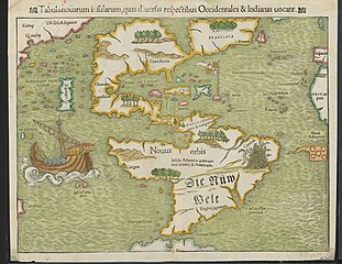
English: Religion and politics are often closely allied, and this was especially the case in the sixteenth century. In this famous map, the Spanish flag flies prominently in the West Indies, while the Portuguese flag dominates the south Atlantic – reflecting pronouncements by Pope Alexander VI in 1493 and the Treaty of Tordesillas between Spain and Portugal of 1494. These declarations divided the non-Christian world between the two countries and charged the Portuguese and Spanish rulers with the responsibility of bringing the non-Christian inhabitants into the Catholic faith. This is reputedly the first printed map to name the Pacific Ocean and it is also among the earliest printed maps of the Western Hemisphere to show North and South America as separate but connected landmasses. The map’s creator, Münster, was a German Catholic Franciscan theologian and priest (ordained in 1512) as well as cartographer, cosmographer, humanist, mathematician, and scholar. |
||||||||||||||||||||||||||
| Fecha | |||||||||||||||||||||||||||
| Fuente | UTA Libraries Cartographic Connections: mapa / texto | ||||||||||||||||||||||||||
| Creador |
|
||||||||||||||||||||||||||
| Adquisición |
English: UTA Libraries Special Collections |
||||||||||||||||||||||||||
| Geotemporal data | |||||||||||||||||||||||||||
| Map location | América | ||||||||||||||||||||||||||
| Georeferencing | If inappropriate please set warp_status = skip to hide. | ||||||||||||||||||||||||||
| Bibliographic data | |||||||||||||||||||||||||||
| Publicación |
Geographia Universalis |
||||||||||||||||||||||||||
| Autor |
|
||||||||||||||||||||||||||
| Lugar de publicación | Basilea | ||||||||||||||||||||||||||
| Impreso por |
|
||||||||||||||||||||||||||
| Archival data | |||||||||||||||||||||||||||
| Colección |
|
||||||||||||||||||||||||||
| Dimensiones | altura: 27,5 cm; ancho: 34,5 cm | ||||||||||||||||||||||||||
| Técnica | grabado coloreado sobre papel | ||||||||||||||||||||||||||
| artwork-references |
Burden The Mapping of North America, nº12 , pp. 15−17 Martin y Martin Maps of Texas and the Southwest, 1513-1900, nº2 , p. 67 |
||||||||||||||||||||||||||
.jpg)

Licencia
[editar]

|
This file was provided to Wikimedia Commons by the University of Texas at Arlington Libraries as part of a cooperation project. The University of Texas at Arlington Libraries is part of the University of Texas at Arlington, a public research university located in Arlington, Texas.
|
|
Este material está en dominio público en los demás países donde el derecho de autor se extiende por 100 años (o menos) tras la muerte del autor. Esta obra está en el dominio público en los Estados Unidos porque fue publicada (o registrada con la Oficina del Derecho de Autor de los E.E. U.U.) antes del 1 de enero de 1929. | |
| Esta obra ha sido identificada como libre de las restricciones conocidas en virtud del derecho de autor, incluyendo todos los derechos conexos. | |
Historial del archivo
Haz clic sobre una fecha y hora para ver el archivo tal como apareció en ese momento.
| Fecha y hora | Miniatura | Dimensiones | Usuario | Comentario | |
|---|---|---|---|---|---|
| actual | 18:23 29 ene 2022 | | 3674 × 2835 (1,93 MB) | Michael Barera (discusión | contribs.) | == {{int:filedesc}} == {{Map |title = {{la|'''''Tabula Novarum Insularum'''''}} |description = {{en|Religion and politics are often closely allied, and this was especially the case in the sixteenth century. In this famous map, the Spanish flag flies prominently in the West Indies, while the Portuguese flag dominates the south Atlantic – reflecting pronouncements by Pope Alexander VI in 1493 and the Treaty of Tordesillas between Spain and Portugal of 1494. These declaration... |
No puedes sobrescribir este archivo.
Usos del archivo
La siguiente página usa este archivo:
Uso global del archivo
Las wikis siguientes utilizan este archivo:
- Uso en bg.wikipedia.org
- Uso en de.wikipedia.org
- Uso en el.wikipedia.org
- Uso en en.wikipedia.org
- Uso en es.wikipedia.org
- Uso en eu.wikipedia.org
- Uso en fr.wikipedia.org
- Uso en it.wikipedia.org
- Uso en ru.wikipedia.org