File:NASA - Visible Earth, Lakes of the African Rift Valley.jpg
跳转到导航
跳转到搜索

本预览的尺寸:800 × 523像素。 其他分辨率:320 × 209像素 | 640 × 419像素 | 1,000 × 654像素。
原始文件 (1,000 × 654像素,文件大小:127 KB,MIME类型:image/jpeg)
说明
说明
添加一行文字以描述该文件所表现的内容
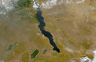
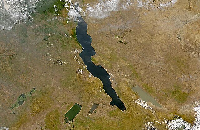
The lakes of the African Rift Valley
摘要
[编辑]
| 描述 | The lakes of the African Rift Valley exhibit wide variations in water color as can be seen in this SeaWiFS image. From left to right the lakes are: Lake Upembe, Lake Mweru, Lake Tanganyika (largest), and Lake Rukwa. This image spans the southeastern corner of the Democratic Republic of the Congo, northeastern Zambia, and southern Tanzania. |
| 日期 | |
| 来源 | http://visibleearth.nasa.gov/view_rec.php?id=757 |
| 作者 | SeaWiFS Project, NASA/Goddard Space Flight Center, and ORBIMAGE |
| This image appeared on English Wikipedia's Main Page in the Did you know? column on 26 March 2004 (see archives). |
许可协议
[编辑]
| This image is from the Sea-viewing Wide Field-of-view Sensor (SeaWiFS) Project and more than 5 years old.
Satellite data captured by the SeaWIFS sensor are released into the public domain 5 years after capture. Data less than five years old can be re-used only for educational or scientific purposes; any commercial use of such images must be coordinated with GeoEye. [1] |
| This work has been released into the public domain by its copyright holder, GeoEye. This applies worldwide. 在一些国家这可能不合法;如果是这样的话,那么: GeoEye无条件地授予任何人以任何目的使用本作品的权利,除非这些条件是法律规定所必需的。
|
文件历史
点击某个日期/时间查看对应时刻的文件。
| 日期/时间 | 缩略图 | 大小 | 用户 | 备注 | |
|---|---|---|---|---|---|
| 当前 | 2005年9月25日 (日) 18:40 | | 1,000 × 654(127 KB) | Moyogo(留言 | 贡献) | from NASA [http://visibleearth.nasa.gov/view_rec.php?id=757] Category:Africa |
您不可以覆盖此文件。
文件用途
以下页面使用本文件:
- File:RiftValleyLakes.JPG(文件重定向)
全域文件用途
以下其他wiki使用此文件:
- af.wikipedia.org上的用途
- als.wikipedia.org上的用途
- ar.wikipedia.org上的用途
- ast.wiktionary.org上的用途
- be.wikipedia.org上的用途
- bh.wikipedia.org上的用途
- ca.wikipedia.org上的用途
- cs.wikipedia.org上的用途
- de.wikipedia.org上的用途
- de.wiktionary.org上的用途
- en.wikipedia.org上的用途
- eo.wikipedia.org上的用途
- es.wikipedia.org上的用途
- eu.wikipedia.org上的用途
- fa.wikipedia.org上的用途
- fi.wikipedia.org上的用途
- fr.wikipedia.org上的用途
- Lac Tanganyika
- Fièvre de la vallée du Rift
- Portail:Zambie/Lumière sur...
- Portail:Burundi/Lumière sur...
- Milieu naturel des poissons d'eau douce
- Lacs de la vallée du Grand Rift
- Lac Rweru
- Lac Cyohoha Sud
- Liste des sites Ramsar en Zambie
- Vallée de rift
- Liste des lacs au Burundi
- Modèle:Palette Lacs du Burundi
- fr.wiktionary.org上的用途
- ga.wikipedia.org上的用途
- he.wikipedia.org上的用途
- hi.wikipedia.org上的用途
- id.wikipedia.org上的用途
- is.wikipedia.org上的用途
- ka.wikipedia.org上的用途
- ku.wikipedia.org上的用途
查看此文件的更多全域用途。