File:NASA Image of Barotse Floodplain.PNG
Fitxer original (538 × 867 píxels, mida del fitxer: 1,13 Mo, tipus MIME: image/png)
Llegendes
Llegendes
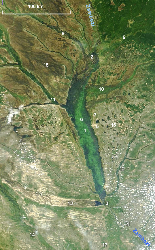
| Descripció | NASA satellite photograph showing the Barotse Floodplain as the bright green to dark blue central region. |
| Data | |
| Font | "Seasonal Flooding in Southern Africa". NASA/Visible Earth, Credit: Jacques Descloitres, MODIS Rapid Response Team, NASA/GSFC. Labels added by User:Rexparry_sydney |
| Autor | Credit: Jacques Descloitres, MODIS Rapid Response Team, NASA/GSFC |
| Permís (Com reutilitzar aquest fitxer) |
NASA general |
| Altres versions | Image:NASA Barotse Floodplain compressed.JPG |
| Aquest fitxer és en el domini públic perquè ha estat creat per la NASA. L'avís legal de la NASA diu que «el material de la NASA no està protegit per copyright si no es diu el contrari». (NASA copyright policy page o JPL Image Use Policy). | ||
 |
Atenció:
|
Key
[modifica]
1 The Zambezi flowing north to south through the middle of the floodplain; 2 confluence of (left to right) the Lungwebungu, Southern Kashiji, Zambezi and Kabompo Rivers, marking the start of the floodplain; 3 end of the floodplain south of Senanga; 4 Ngonye Falls on the Zambezi; 5 Mongu, capital of Barotseland; 6 Lealui, seat of the Litunga on the floodplain; 7 Limulunga, seat of the Litunga during the flood; 8 swamps and floodplain of the Lungwebungu; 9 the Kabompo drains an area of Cryptosepalum dry forest; 10 Luena Flats (floodplain); 11 Luanginga River floodplain near Kalabo; 12 Lui River with narrow floodplain; 13 a broad floodplain which carries overspill from high floods of the Cuando River in Angola; 14 Cuando river and floodplain, on the border between Angola and Zambia; 15 Liuwa Plain National Park; 16 The flat sandy Miombo woodland west of Mongu features many pans; 17 Sioma Ngwezi National Park.
Historial del fitxer
Cliqueu una data/hora per veure el fitxer tal com era aleshores.
| Data/hora | Miniatura | Dimensions | Usuari/a | Comentari | |
|---|---|---|---|---|---|
| actual | 05:40, 19 nov 2007 | | 538 × 867 (1,13 Mo) | Rexparry sydney~commonswiki (discussió | contribucions) | {{Information |Description=NASA satellite photograph showing the Barotse Floodplain as the bright green to dark blue central region. |Source=[http://visibleearth.nasa.gov/view_rec.php?id=6926 "Seasonal Flooding in Southern Africa".] ''NASA/Visible Earth'' |
No podeu sobreescriure aquest fitxer.
Ús del fitxer
No hi ha pàgines que utilitzin aquest fitxer.
Ús global del fitxer
Utilització d'aquest fitxer en altres wikis:
- Utilització a ca.wikipedia.org
- Utilització a en.wikipedia.org
- Utilització a es.wikipedia.org
- Utilització a ml.wikipedia.org