File:NASA satellite photograph of the Hawaiian islands of O‘ahu, Moloka‘i, Lāna‘i, Kaho‘olawe, and Maui (left to right).jpeg

Originaldatei (1.024 × 586 Pixel, Dateigröße: 283 KB, MIME-Typ: image/jpeg)
Bildtexte
Kurzbeschreibungen
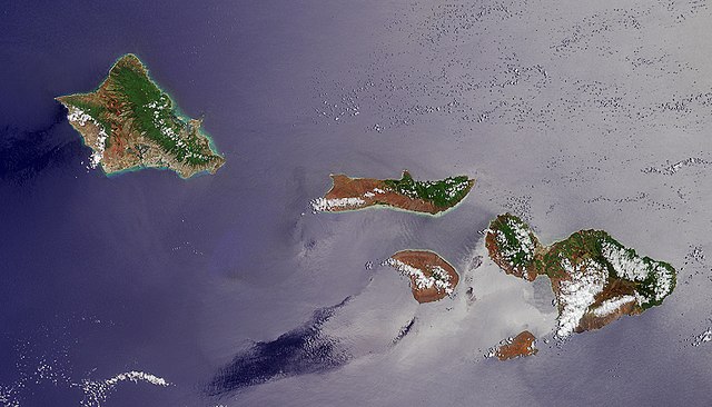
This Multiangle Imaging Spectro-Radiometer (MISR) image of five Hawaiian Islands was acquired by the instrument's vertical- viewing (nadir) camera on June 3, 2000.
The image shows the islands of Oahu, Molokai, Lanai, Maui, and Kahoolawe. The prevailing Pacific trade winds bring higher levels of rainfall to the eastern slopes of the islands, leading to a greater abundance of vegetation on the windward coasts. The small change in observation angle across the nadir camera’s field-of- view causes the right-hand portion of the image to be more affected by Sun glint, making the ocean surface appear brighter.
Oahu is the westernmost of the islands seen in this image. Waikiki Beach and the city of Honolulu are located on the southern shore, to the west of Diamond Head caldera.
MISR is one of several Earth-observing instruments on the Terra satellite, launched in December 1999. The Terra spacecraft, the flagship of a fleet of satellites dedicated to understanding our global environment, is part of NASA's Earth Sciences Enterprise, a long-term research program dedicated to understanding how human-induced and natural changes affect our world.
Image courtesy NASA/GSFC/JPL, MISR Team
| Diese Datei ist gemeinfrei (public domain), da sie von der NASA erstellt worden ist. Die NASA-Urheberrechtsrichtlinie besagt, dass „NASA-Material nicht durch Urheberrecht geschützt ist, wenn es nicht anders angegeben ist“. (NASA-Urheberrechtsrichtlinie-Seite oder JPL Image Use Policy). | ||
 |
Warnung:
|
Dateiversionen
Klicke auf einen Zeitpunkt, um diese Version zu laden.
| Version vom | Vorschaubild | Maße | Benutzer | Kommentar | |
|---|---|---|---|---|---|
| aktuell | 06:47, 18. Feb. 2005 | | 1.024 × 586 (283 KB) | Ævar Arnfjörð Bjarmason (Diskussion | Beiträge) |
Du kannst diese Datei nicht überschreiben.
Dateiverwendung
Die folgende Seite verwendet diese Datei:
Globale Dateiverwendung
Die nachfolgenden anderen Wikis verwenden diese Datei:
- Verwendung auf ar.wikipedia.org
- Verwendung auf de.wikipedia.org
- Verwendung auf fr.wikipedia.org
- Verwendung auf hr.wikipedia.org
- Verwendung auf is.wikipedia.org
- Verwendung auf lmo.wikipedia.org
- Verwendung auf nds.wikipedia.org
- Verwendung auf pms.wikipedia.org
- Verwendung auf ro.wikipedia.org
.jpeg&oldid=831105809)