File:NOAA Katrina NOLA 17th Street breach Aug 31 2005.jpg
Ir a la navegación
Ir a la búsqueda
Tamaño de esta previsualización: 490 × 599 píxeles. Otras resoluciones: 196 × 240 píxeles | 392 × 480 píxeles | 628 × 768 píxeles | 1082 × 1323 píxeles.
Archivo original (1082 × 1323 píxeles; tamaño de archivo: 954 kB; tipo MIME: image/jpeg)
Leyendas
Leyendas
Añade una explicación corta acerca de lo que representa este archivo
Resumen
[editar]
| Descripción |
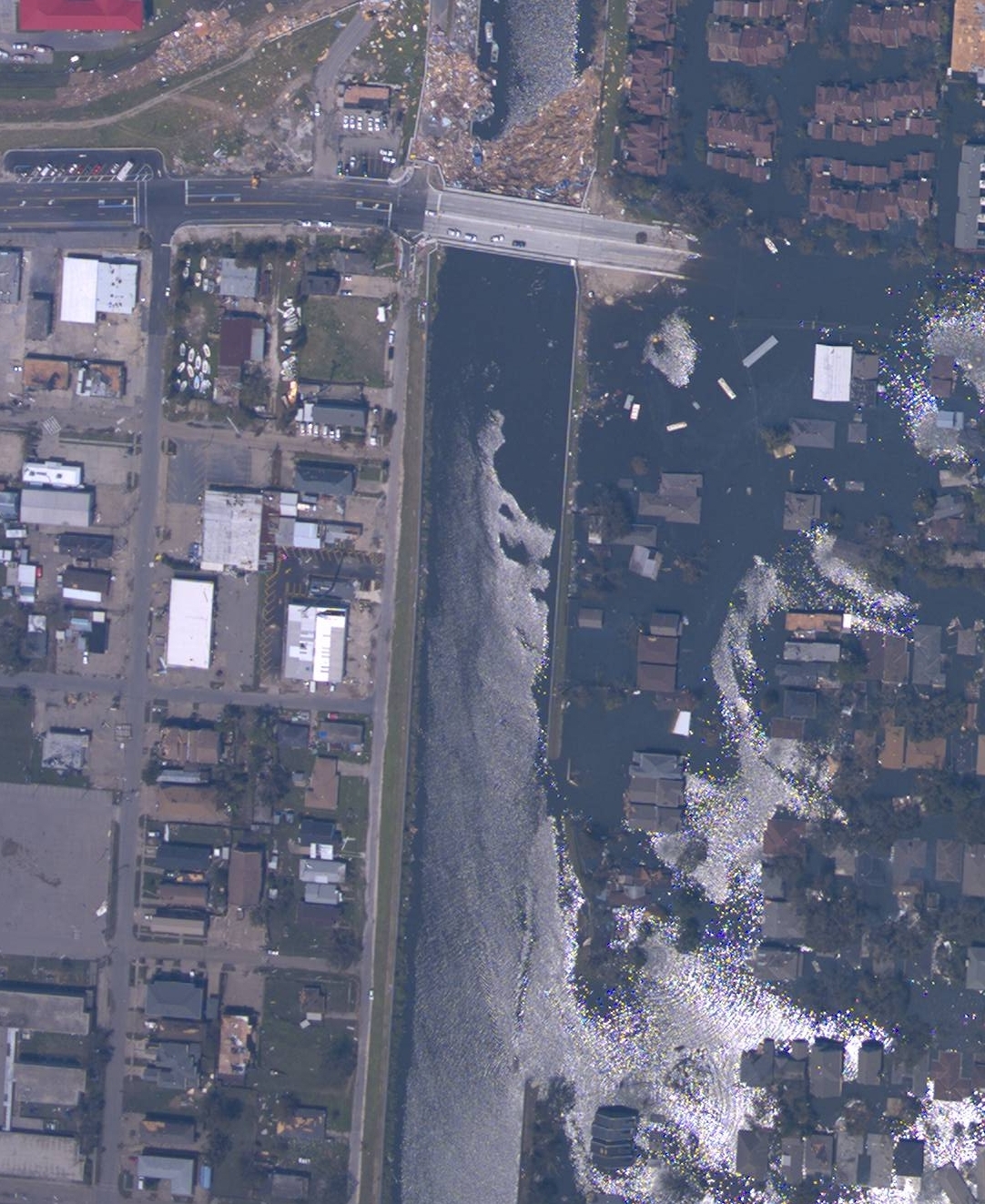
English: Breach in 17th Street Canal wall in New Orleans, Louisiana. A part of the West End neighborhood of New Orleans is to the right on the east side of the canal, severely flooded; to the left, west of the Canal, is part of Metairie, Louisiana, not flooded. NOAA aerial image taken August 31, 2005. Metal girders and/or plates were later hung along the north side of the Hammond Highway bridge (gray bridge at top, with debris in canal on the north/Lake Pontchartrain side) to block the entrance to the canal. The breach in the canal berm and canal wall (lower right) were closed with helicopter-dropped sandbags and trucks dumping fill southward from Hammond Highway. The breach was closed Monday, September 5, 2005. An opening was then made in the metal wall to allow city drainage through the canal. Repair of the canal levee and floodwall are still ongoing as of April 2006. |
| Fecha | |
| Fuente | http://ngs.woc.noaa.gov/storms/katrina/24425575.jpg |
| Autor | NOAA |
Source
[editar]
http://ngs.woc.noaa.gov/storms/katrina/24425575.jpg
Cropped and rotated 90 degrees so top is toward north.
full photo uploaded as Image:17StreetCanalWestEndAfterKatrina.jpg
Licencia
[editar]
Esta imagen es de dominio público porque contiene material que vino originalmente de la Administración Nacional Oceánica y Atmosférica de los Estados Unidos de América, recibidas o hechas en el curso de las funciones oficiales de un empleado.
|
Historial del archivo
Haz clic sobre una fecha y hora para ver el archivo tal como apareció en ese momento.
| Fecha y hora | Miniatura | Dimensiones | Usuario | Comentario | |
|---|---|---|---|---|---|
| actual | 06:38 7 sep 2005 | | 1082 × 1323 (954 kB) | SEWilco (discusión | contribs.) | Breach in 17th Street Canal wall in New Orleans, Louisiana. NOAA aerial image taken August 31, 2005. == Source == http://ngs.woc.noaa.gov/storms/katrina/24425575.jpg Cropped and rotated 90 degrees so top is toward north. Category:Hurricane Katrina |
No puedes sobrescribir este archivo.
Usos del archivo
La siguiente página usa este archivo:
Uso global del archivo
Las wikis siguientes utilizan este archivo:
- Uso en en.wikipedia.org
- Uso en en.wikinews.org
- Uso en es.wikipedia.org
- Uso en pl.wikipedia.org