File:NPS jewel-cave-layout-map.pdf
跳转到导航
跳转到搜索

此PDF文件的JPG预览的大小:671 × 599像素。 其他分辨率:269 × 240像素 | 538 × 480像素 | 739 × 660像素。
原始文件 (739 × 660像素,文件大小:7.21 MB,MIME类型:application/pdf)
说明
说明
添加一行文字以描述该文件所表现的内容
摘要[编辑]
| 描述 |
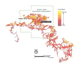
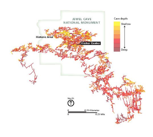
English: Jewel Cave underground map, showing the passageways, tunnels, and chambers that make up the Jewel Cave complex . |
| 日期 | |
| 来源 | U.S. National Park Service (http://npmaps.com/wp-content/uploads/jewel-cave-layout-map.pdf) |
| 作者 | U.S. National Park Service, restoration/cleanup by Matt Holly |
| 其他版本 |
 |
许可协议[编辑]
| 该图片或媒体为美国国家公园管理局雇员在执行公务时创建。作为美国联邦政府的作品,此作品在美国境内属于公有领域。更多信息请参考美国国家公园管理局网站及美国国家公园管理局版权政策。 |
文件历史
点击某个日期/时间查看对应时刻的文件。
| 日期/时间 | 缩略图 | 大小 | 用户 | 备注 | |
|---|---|---|---|---|---|
| 当前 | 2017年5月17日 (三) 00:17 |  | 739 × 660(7.21 MB) | RKBot(留言 | 贡献) | =={{int:filedesc}}== {{Information |description= {{en|1=Jewel Cave underground map, showing the passageways, tunnels, and chambers that make up the Jewel Cave complex .}} |date= 2016-04-22 |source= U.S. National Park Service (http://npmaps.com/wp-conte... |
您不可以覆盖此文件。
文件用途
以下2个页面使用本文件:
全域文件用途
以下其他wiki使用此文件:
- zh.wikipedia.org上的用途