File:NRC-regions-map.gif
跳至導覽
跳至搜尋
無更高解析度可提供。
NRC-regions-map.gif (550 × 415 像素,檔案大小:43 KB,MIME 類型:image/gif)
說明
說明
添加單行說明來描述出檔案所代表的內容
摘要
[編輯]
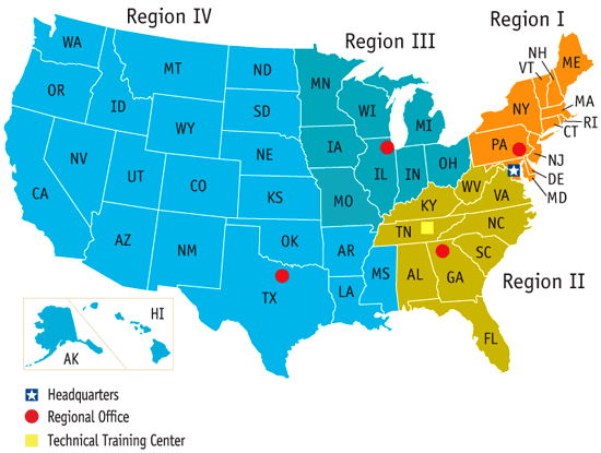
| 描述 | Map of the United States by Nuclear Regulatory Commission (NRC) Region (Now shows Mississippi in Region 4, rather than 2.) |
| 日期 | Last revised prior to July 21, 2008 (previous: February 17, 2007) |
| 來源 | http://www.nrc.gov/images/info-finder/region-state/regions-map.gif |
| 作者 | Nuclear Regulatory Commission |
| 授權許可 (重用此檔案) |
"Information generated by the NRC or developed under an NRC contract is not copyrighted, unless indicated otherwise. Non-copyrighted material can be reproduced without permission; citation of the NRC as the source of the information is appreciated." |
授權條款
[編輯]
| This image is a work of a Nuclear Regulatory Commission employee, taken or made as part of that person's official duties. As a work of the U.S. federal government, the image is in the public domain in the United States. |
檔案歷史
點選日期/時間以檢視該時間的檔案版本。
| 日期/時間 | 縮圖 | 尺寸 | 使用者 | 備註 | |
|---|---|---|---|---|---|
| 目前 | 2008年7月21日 (一) 17:49 | | 550 × 415(43 KB) | Wwoods(留言 | 貢獻) | |
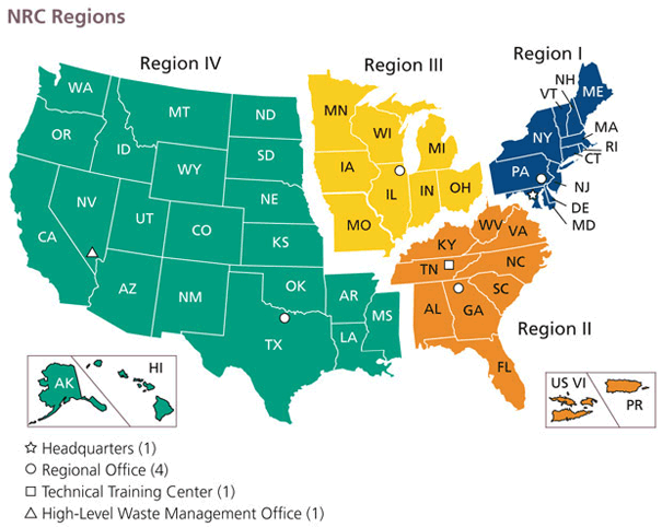
| 2007年1月12日 (五) 18:22 |  | 560 × 350(23 KB) | BigrTex(留言 | 貢獻) | {{Information |Description=Map of the United States by Nuclear Regulatory Commission (NRC) Region |Source=http://www.nrc.gov/images/info-finder/region-state/regions-map.gif |Date=Last revised Tuesday, September 20, 2005 |Author=Nuclear Regulatory Commissi |
無法覆蓋此檔案。
檔案用途
全域檔案使用狀況
以下其他 wiki 使用了這個檔案:
- de.wikipedia.org 的使用狀況
- en.wikipedia.org 的使用狀況
- en.wikibooks.org 的使用狀況
- fr.wikipedia.org 的使用狀況
- ja.wikipedia.org 的使用狀況
- ko.wikipedia.org 的使用狀況
- pl.wikipedia.org 的使用狀況
- zh.wikipedia.org 的使用狀況