File:NRHA 1.png
ナビゲーションに移動
検索に移動

このプレビューのサイズ: 533 × 600 ピクセル。 その他の解像度: 213 × 240 ピクセル | 426 × 480 ピクセル | 682 × 768 ピクセル | 910 × 1,024 ピクセル | 2,202 × 2,478 ピクセル。
元のファイル (2,202 × 2,478 ピクセル、ファイルサイズ: 2.02メガバイト、MIME タイプ: image/png)
キャプション
キャプション
このファイルの内容を1行で記述してください
概要
[編集]
| 解説 |
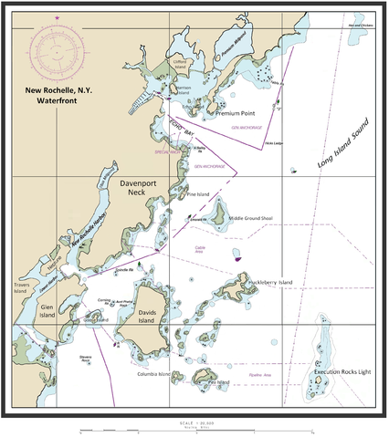
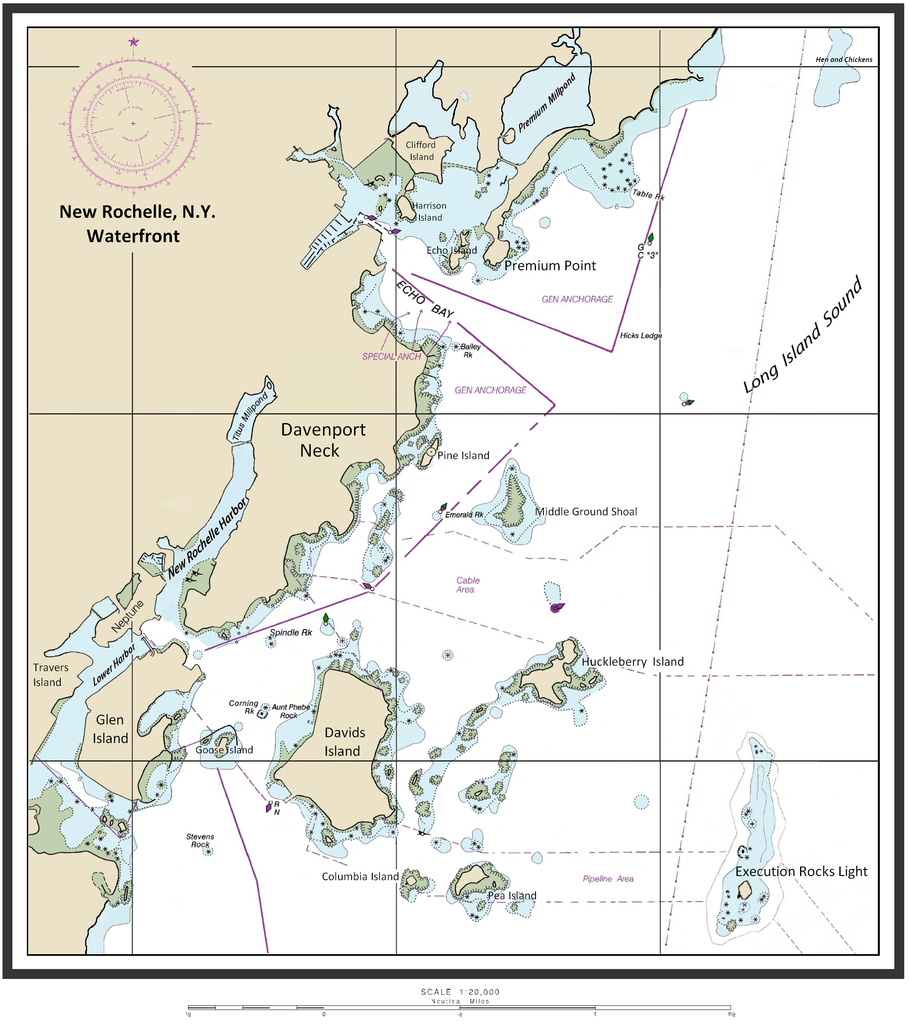
English: Map of New Rochelle waterfront including the harbor management areas, islands, and inlets. |
| 日付 | 2015年2月14日 (当初のアップロード日) |
| 原典 | I (ClarckeBAR (talk)) created this work (custom map of New Rochelle Harbor Area with names/locations of geographic features, landforms). Underlying/base map data provided by The National Oceanic and Atmospheric Administration for use in nautical chart production. ( see print example (Western LIS) of published NOAA nautical chart). Main data source - The Seamless Raster Navigational Chart Server, under the following "Copyright Notice" - As required by 17 U.S.C. 403, third parties producing copyrighted works consisting predominantly of the material produced by U.S. government agencies must provide notice with such work(s) identifying the U.S. Government material incorporated and stating that such material is not subject to copyright protection within the United States. The information on government web pages is in the public domain and not subject to copyright protection within the United States unless specifically annotated otherwise (copyright may be held elsewhere). Foreign copyrights may apply. |
| 作者 | 英語版ウィキペディアのClarckeBARさん |
ライセンス
[編集]
この作品の著作権者であるClarckeBARは、この作品を以下のライセンスで提供しています。
このファイルはクリエイティブ・コモンズ 表示 3.0 非移植ライセンスのもとに利用を許諾されています。
帰属: ClarckeBAR
- あなたは以下の条件に従う場合に限り、自由に
- 共有 – 本作品を複製、頒布、展示、実演できます。
- 再構成 – 二次的著作物を作成できます。
- あなたの従うべき条件は以下の通りです。
- 表示 – あなたは適切なクレジットを表示し、ライセンスへのリンクを提供し、変更があったらその旨を示さなければなりません。これらは合理的であればどのような方法で行っても構いませんが、許諾者があなたやあなたの利用行為を支持していると示唆するような方法は除きます。
元のアップロードログ
[編集]
元のファイルページはこちら。以下の利用者は全てen.wikipediaに属します。
| 日付と時刻 | 寸法 | 利用者 | コメント |
|---|---|---|---|
| 2015-02-14 10:46 | 2202×2478× (2113870 bytes) | ClarckeBAR | {{Information |Description = Map of New Rochelle waterfront including the harbor management areas, islands, and inlets. |Source = I (~~~) created this work entirely by myself. |Date = ~~~~~ |Author = ~~~ |other_version... |
ファイルの履歴
過去の版のファイルを表示するには、その版の日時をクリックしてください。
| 日付と時刻 | サムネイル | 寸法 | 利用者 | コメント | |
|---|---|---|---|---|---|
| 現在の版 | 2015年9月4日 (金) 06:28 | | 2,202 × 2,478 (2.02メガバイト) | Innotata (トーク | 投稿記録) | Transferred from en.wikipedia |
このファイルは上書きできません。
ファイルの使用状況
このファイルを使用しているページはありません。
グローバルなファイル使用状況
以下に挙げる他のウィキがこの画像を使っています:
- ceb.wikipedia.org での使用状況
- de.wikipedia.org での使用状況
- en.wikipedia.org での使用状況
- Westchester County, New York
- Columbia Island (New York)
- Travers Island, New York
- Pea Island (New Rochelle, New York)
- Titus Mill-Pond & New York State Tidal Wetlands
- New Rochelle Harbor (Long Island Sound)
- Echo Bay (Long Island Sound)
- Davenport Neck
- Premium Point, New Rochelle
- Pine Island (New Rochelle)
- Premium Mill-Pond
- fi.wikipedia.org での使用状況
- fr.wikipedia.org での使用状況
- ja.wikipedia.org での使用状況
- www.wikidata.org での使用状況