File:NUTS 3 regions of Wales map.svg
跳转到导航
跳转到搜索

此SVG文件的PNG预览的大小:501 × 599像素。 其他分辨率:201 × 240像素 | 401 × 480像素 | 642 × 768像素 | 856 × 1,024像素 | 1,713 × 2,048像素 | 1,047 × 1,252像素。
原始文件 (SVG文件,尺寸为1,047 × 1,252像素,文件大小:325 KB)
说明
说明
添加一行文字以描述该文件所表现的内容
摘要
[编辑]
| 描述 |
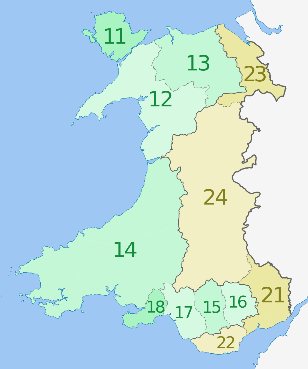
Deutsch: Karte von Wales, Vereinigtes Königreich: NUTS-Raumeinheiten auf den Ebenen NUTS3.
Quadratische Plattkarte, N-S-Streckung 163 %. Geographische Begrenzung der Karte:
English: Map of the NUTS 3 regions of Wales, United Kingdom.
Equirectangular projection, N/S stretching 163 %. Geographic limits of the map:
|
| 日期 | (UTC) |
| 来源 |
本文件衍生自: Wales location map.svg:  |
| 作者 |
|
| NUTS 1 | Code | NUTS 2 | Code | NUTS 3 | Code |
|---|---|---|---|---|---|
| Wales | UKL | West Wales and The Valleys | UKL1 | Isle of Anglesey | UKL11 |
| Gwynedd | UKL12 | ||||
| Conwy and Denbighshire | UKL13 | ||||
| South West Wales (Ceredigion, Carmarthenshire, Pembrokeshire) | UKL14 | ||||
| Central Valleys (Merthyr Tydfil, Rhondda Cynon Taff) | UKL15 | ||||
| Gwent Valleys (Blaenau Gwent, Caerphilly, Torfaen) | UKL16 | ||||
| Bridgend and Neath Port Talbot | UKL17 | ||||
| Swansea | UKL18 | ||||
| East Wales | UKL2 | Monmouthshire and Newport | UKL21 | ||
| Cardiff and Vale of Glamorgan | UKL22 | ||||
| Flintshire and Wrexham | UKL23 | ||||
| Powys | UKL24 |
许可协议
[编辑]
我,本作品著作权人,特此采用以下许可协议发表本作品:
本文件采用知识共享署名-相同方式共享 3.0 未本地化版本许可协议授权。
署名: Dr Greg and NordNordWest
- 您可以自由地:
- 共享 – 复制、发行并传播本作品
- 修改 – 改编作品
- 惟须遵守下列条件:
- 署名 – 您必须对作品进行署名,提供授权条款的链接,并说明是否对原始内容进行了更改。您可以用任何合理的方式来署名,但不得以任何方式表明许可人认可您或您的使用。
- 相同方式共享 – 如果您再混合、转换或者基于本作品进行创作,您必须以与原先许可协议相同或相兼容的许可协议分发您贡献的作品。
原始上传日志
[编辑]
This image is a derivative work of the following images:
- File:Wales_location_map.svg licensed with Cc-by-sa-3.0
- 2009-06-24T13:27:54Z NordNordWest 1047x1252 (242334 Bytes) {{Information |Description= {{de|Positionskarte von [[:de:Wales|Wales]], [[:de:Vereinigtes Königreich|Vereinigtes Königreich]]}} Quadratische Plattkarte, N-S-Streckung 163 %. Geographische Begrenzung der Karte: * N: 53.5°
Uploaded with derivativeFX
文件历史
点击某个日期/时间查看对应时刻的文件。
| 日期/时间 | 缩略图 | 大小 | 用户 | 备注 | |
|---|---|---|---|---|---|
| 当前 | 2012年8月1日 (三) 02:30 | | 1,047 × 1,252(325 KB) | Dr Greg(留言 | 贡献) | corrected labelling error (23 & 24 transposed) |
| 2012年6月5日 (二) 01:10 |  | 1,047 × 1,252(325 KB) | Dr Greg(留言 | 贡献) | == {{int:filedesc}} == {{Information |Description={{de|Karte von Wales, Vereinigtes Königreich: NUTS-Raumeinheiten auf den Ebenen NUTS3. Quadratische Plattkarte, N-S-Streckung 163 %. Geogr... |
您不可以覆盖此文件。
文件用途
以下页面使用本文件:
全域文件用途
以下其他wiki使用此文件:
- ar.wikipedia.org上的用途
- cy.wikipedia.org上的用途
- de.wikipedia.org上的用途
- en.wikipedia.org上的用途
- fi.wikipedia.org上的用途
- it.wikipedia.org上的用途
- lt.wikipedia.org上的用途
- ru.wikipedia.org上的用途
- uk.wikipedia.org上的用途
- zh.wikipedia.org上的用途