File:Nam-Viet 200bc.jpg
পরিভ্রমণে চলুন
অনুসন্ধানে চলুন
এই প্রাকদর্শনের আকার: ৭২৮ × ৫৯৯ পিক্সেল। অন্যান্য আকারসমূহ: ২৯২ × ২৪০ পিক্সেল | ৫৮৩ × ৪৮০ পিক্সেল | ৯৩৩ × ৭৬৮ পিক্সেল | ১,১৬৬ × ৯৬০ পিক্সেল।
মূল ফাইল (১,১৬৬ × ৯৬০ পিক্সেল, ফাইলের আকার: ৮৫৬ কিলোবাইট, এমআইএমই ধরন: image/jpeg)
ক্যাপশনসমূহ
ক্যাপশন
এই ফাইল কি প্রতিনিধিত্ব করছে তার এক লাইন ব্যাখ্যা যোগ করুন

|
This historical map image could be re-created using vector graphics as an SVG file. This has several advantages; see Commons:Media for cleanup for more information. If an SVG form of this image is available, please upload it and afterwards replace this template with
{{vector version available|new image name}}.
It is recommended to name the SVG file “Nam-Viet 200bc.svg”—then the template Vector version available (or Vva) does not need the new image name parameter. |


সারাংশ[সম্পাদনা]
| বিবরণ |
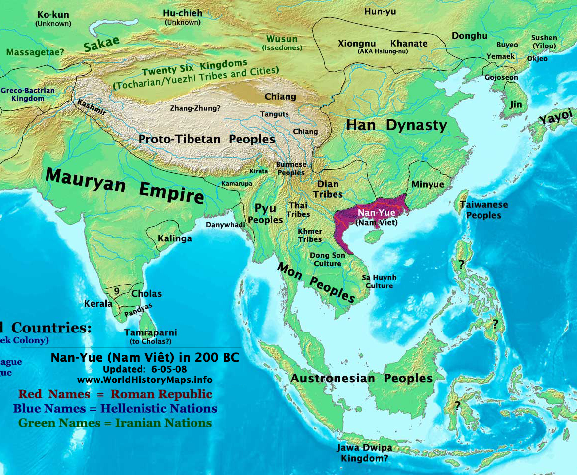
English: Map of ancient Nam Việt (204 BCE - 111 BCE) - an ancient kingdom that consisted of parts of the modern southern Chinese provinces of Guangdong, Guangxi, Yunnan and northern Vietnam.
|
| তারিখ | ১০ জুলাই ২০০৯ (মূল আপলোডের তারিখ) |
| উৎস | en.wikipedia থেকে কমন্সে স্থানান্তরিত করা হয়েছে Alagos কর্তৃক। |
| লেখক | মূল আপলোডকারী ছিলেন ইংরেজি উইকিপিডিয়া-এর Sea888 |
লাইসেন্স প্রদান[সম্পাদনা]
এই ফাইলটি ক্রিয়েটিভ কমন্স অ্যাট্রিবিউশন-শেয়ার অ্যালাইক ৩.০ আনপোর্টেড লাইসেন্সের আওতায় লাইসেন্সকৃত।
- আপনি স্বাধীনভাবে:
- বণ্টন করতে পারেন – এ কাজটি অনুলিপি, বিতরণ এবং প্রেরণ করতে পারেন
- পুনঃমিশ্রণ করতে পারেন – কাজটি অভিযোজন করতে পারেন
- নিম্নের শর্তাবলীর ভিত্তিতে:
- স্বীকৃতিপ্রদান – আপনাকে অবশ্যই যথাযথ স্বীকৃতি প্রদান করতে হবে, লাইসেন্সের একটি লিঙ্ক সরবরাহ করতে হবে এবং কোনো পরিবর্তন হয়েছে কিনা তা নির্দেশ করতে হবে। আপনি যেকোনো যুক্তিসঙ্গত পদ্ধতিতে এটি করতে পারেন। কিন্তু এমন ভাবে নয়, যাতে প্রকাশ পায় যে লাইসেন্সধারী আপনাকে বা আপনার এই ব্যবহারের জন্য অনুমোদন দিয়েছে।
- একইভাবে বণ্টন – আপনি যদি কাজটি পুনঃমিশ্রণ, রুপান্তর, বা এর ওপর ভিত্তি করে নতুন সৃষ্টিকর্ম তৈরি করেন, তবে আপনাকে অবশ্যই আপনার অবদান একই লাইসেন্স বা একই রকমের লাইসেন্সের আওতায় বিতরণ করতে হবে।
মূল আপলোড লগ[সম্পাদনা]
মূল বিবরণ পাতাটি এখানে ছিল। নিম্নলিখিত সকল ব্যবহারকারীর নাম en.wikipedia-এ উল্লেখ করা ছিল।
Upload date | User | Bytes | Dimensions | Comment
- 2009-07-10 19:33:35 | Sea888 | 876342 | 1166×960 | Author: Thomas A. Lessman. Source URL: http://www.worldhistorymaps.info/maps.html. Image was created by me (Thomas Lessman) based on map of Eastern Hemisphere in 200 BC. Image is free for public and/or educational use. I would appreciate a mention if this
ফাইলের ইতিহাস
যেকোনো তারিখ/সময়ে ক্লিক করে দেখুন ফাইলটি তখন কী অবস্থায় ছিল।
| তারিখ/সময় | সংক্ষেপচিত্র | মাত্রা | ব্যবহারকারী | মন্তব্য | |
|---|---|---|---|---|---|
| বর্তমান | ১৫:২৭, ৫ জানুয়ারি ২০১৩ | | ১,১৬৬ × ৯৬০ (৮৫৬ কিলোবাইট) | Alagos (আলোচনা | অবদান) | {{CH2MoveToCommons|en.wikipedia|year={{subst:CURRENTYEAR}}|month={{subst:CURRENTMONTHNAME}}|day={{subst:CURRENTDAY}}}} The tool and the bot are operated by User:Jan Luca and User:Magnus Manske. =={{int:filedesc}}== {{Information |description=A... |
আপনি এই ফাইলটি প্রতিস্থাপন করতে পারবেন না।
ফাইলের ব্যবহার
এই ফাইল ব্যবহার করে এমন কোনো পাতা নেই।
ফাইলের বৈশ্বিক ব্যবহার
নিচের অন্যান্য উইকিগুলো এই ফাইলটি ব্যবহার করে:
- ast.wikipedia.org-এ ব্যবহার
- bcl.wikipedia.org-এ ব্যবহার
- bn.wikipedia.org-এ ব্যবহার
- en.wikipedia.org-এ ব্যবহার
- es.wikipedia.org-এ ব্যবহার
- eu.wikipedia.org-এ ব্যবহার
- fi.wikipedia.org-এ ব্যবহার
- fr.wikipedia.org-এ ব্যবহার
- id.wikipedia.org-এ ব্যবহার
- ja.wikipedia.org-এ ব্যবহার
- pnb.wikipedia.org-এ ব্যবহার
- pt.wikipedia.org-এ ব্যবহার
- ru.wikipedia.org-এ ব্যবহার
- th.wikipedia.org-এ ব্যবহার
- uk.wikipedia.org-এ ব্যবহার
- ur.wikipedia.org-এ ব্যবহার
- vi.wikipedia.org-এ ব্যবহার
বিষয়শ্রেণীসমূহ:
- Maps of Nanyue
- Maps showing 3rd-century BC history
- Modifications of the history maps by Thomas A. Lessmann
- Maps of the history of China
- Maps of the history of Vietnam
- Ancient Vietnam
- Guangdong
- Vietnamese monarchy
- 3rd-century BC establishments
- History of Vietnam
- Former countries in Vietnam
- Maps of 3rd-century BC Asia