File:Napa River Napa-Sonoma Marsh.jpg
Zur Navigation springen
Zur Suche springen

Größe dieser Vorschau: 800 × 534 Pixel. Weitere Auflösungen: 320 × 214 Pixel | 640 × 427 Pixel | 1.024 × 683 Pixel | 1.500 × 1.001 Pixel.
Originaldatei (1.500 × 1.001 Pixel, Dateigröße: 469 KB, MIME-Typ: image/jpeg)
Bildtexte
Kurzbeschreibungen
Ergänze eine einzeilige Erklärung, was diese Datei darstellt.
| Beschreibung |
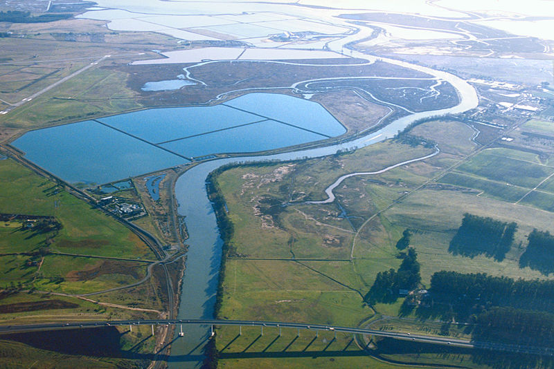
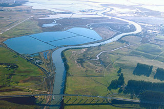
English: Aerial view of the southern end of the Napa River in Napa County, California, USA. The river empties into Napa-Sonoma Marsh (top) and then into San Pablo Bay at the northern end of San Francisco Bay. Most of this picture is located in Napa County. At the extreme top edge of the picture is the border with Solano County. View is to the south.
Coordinates: 38°13′28.91″N 122°17′45.7″W / 38.2246972°N 122.296028°W |
|||
| Ort | Napa County, Califiornia, USA | |||
| Datum | not specified or unknown | |||
| Quelle |
U.S. Army Corps of Engineers Digital Visual Library Image page Image description page Digital Visual Library home page |
|||
| Urheber | U.S. Army Corps of Engineers, photographer not specified or unknown | |||
| Genehmigung (Weiternutzung dieser Datei) |
|
|||
| Andere Versionen |
.jpg)
Dateiversionen
Klicke auf einen Zeitpunkt, um diese Version zu laden.
| Version vom | Vorschaubild | Maße | Benutzer | Kommentar | |
|---|---|---|---|---|---|
| aktuell | 02:53, 4. Mai 2007 | | 1.500 × 1.001 (469 KB) | DanMS (Diskussion | Beiträge) | {{Information | Description = {{en|Aerial view of the southern end of the Napa River in Napa County, California, USA. The river empties into Napa-Sonoma Marsh (top) and then into San Pablo Bay at the northern end of San Francisco Bay. Most of this pict |
Du kannst diese Datei nicht überschreiben.
Dateiverwendung
Die folgenden 2 Seiten verwenden diese Datei:
Globale Dateiverwendung
Die nachfolgenden anderen Wikis verwenden diese Datei:
- Verwendung auf de.wikipedia.org
- Verwendung auf en.wikipedia.org
- Verwendung auf fr.wikipedia.org
- Verwendung auf it.wikipedia.org
- Verwendung auf ja.wikipedia.org
- Verwendung auf nl.wikipedia.org
- Verwendung auf ru.wikipedia.org
- Verwendung auf www.wikidata.org