File:Navy Island map.png
跳至導覽
跳至搜尋
無更高解析度可提供。
Navy_Island_map.png (478 × 600 像素,檔案大小:174 KB,MIME 類型:image/png)
說明
說明
添加單行說明來描述出檔案所代表的內容
摘要
[編輯]
| 描述 |
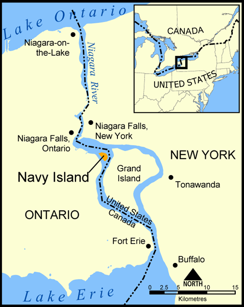
A map showing the location of Navy Island in the Niagara River. The nearby Grand Island is also shown, as are the towns of Niagara Falls, Niagara-on-the-Lake, Tonawanda, Buffalo, and Fort Erie. Created by NormanEinstein, May 11, 2005. |
| 日期 | 2005年5月11日 (原始上傳日期) |
| 來源 | 无法识别来源。根据版权声明推断为其自己的作品。 |
| 作者 | 无法识别作者。根据版权声明推断作者为NormanEinstein。 |
授權條款
[編輯]
我,本作品的著作權持有者,決定用以下授權條款發佈本作品:

|
已授權您依據自由軟體基金會發行的無固定段落、封面文字和封底文字GNU自由文件授權條款1.2版或任意後續版本,對本檔進行複製、傳播和/或修改。該協議的副本列在GNU自由文件授權條款中。 |
| 此檔案採用創用CC 姓名標示-相同方式分享 3.0 未在地化版本授權條款。 | ||
| ||
| 已新增授權條款標題至此檔案,作為GFDL授權更新的一部份。 |
您可以選擇您需要的授權條款。
檔案歷史
點選日期/時間以檢視該時間的檔案版本。
| 日期/時間 | 縮圖 | 尺寸 | 使用者 | 備註 | |
|---|---|---|---|---|---|
| 目前 | 2005年5月19日 (四) 14:32 | | 478 × 600(174 KB) | NormanEinstein(留言 | 貢獻) | |
| 2005年5月11日 (三) 20:05 |  | 683 × 740(116 KB) | NormanEinstein(留言 | 貢獻) | A map showing the location of Navy Island in the Niagara River. The nearby Grand Island is also shown, as are the towns of Niagara Falls, Niagara-on-the-Lake, Tonawanda, Buffalo, and Fort Erie. Created by NormanEinstein. {{PD-self}} |
無法覆蓋此檔案。
檔案用途
沒有使用此檔案的頁面。
全域檔案使用狀況
以下其他 wiki 使用了這個檔案:
- ar.wikipedia.org 的使用狀況
- be.wikipedia.org 的使用狀況
- bn.wikipedia.org 的使用狀況
- cv.wikipedia.org 的使用狀況
- de.wikipedia.org 的使用狀況
- en.wikipedia.org 的使用狀況
- es.wikipedia.org 的使用狀況
- fr.wikipedia.org 的使用狀況
- hyw.wikipedia.org 的使用狀況
- it.wikipedia.org 的使用狀況
- ja.wikipedia.org 的使用狀況
- sh.wikipedia.org 的使用狀況
- sv.wikipedia.org 的使用狀況
- sw.wikipedia.org 的使用狀況
- tr.wikipedia.org 的使用狀況
- uk.wikipedia.org 的使用狀況
- zh.wikipedia.org 的使用狀況