File:Nazi Germany.png
Aller à la navigation
Aller à la recherche

Taille de cet aperçu : 772 × 600 pixels. Autres résolutions : 309 × 240 pixels | 618 × 480 pixels | 989 × 768 pixels | 1 200 × 932 pixels.
Fichier d’origine (1 200 × 932 pixels, taille du fichier : 263 kio, type MIME : image/png)
Légendes
Légendes
Ajoutez en une ligne la description de ce que représente ce fichier

|
Une version vectorielle de cette image existe, dans le format « SVG ». Si elle n’est pas inférieure, elle devrait être utilisée à la place de la présente version pour des affichages en plus grandes dimensions ou nécessitant une meilleure résolution.
File:Nazi Germany.png → File:Nazi Germany.svg
Pour plus d’informations sur les images vectorielles, consultez la page de transition de Commons vers le format SVG. Voir aussi les informations à propos de la manière dont le logiciel MediaWiki gère les images au format SVG. |
 |
Description[modifier]
| Description |
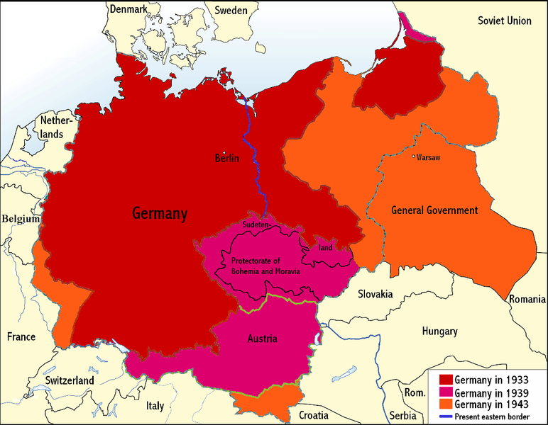
English: An overview map of Nazi Germany to 1943. |
||||||||
| Date | |||||||||
| Source | Transferred from the English Wikipedia. Original file is/was here. (Original upload log available below.) | ||||||||
| Auteur | Wikinist | ||||||||
| Autorisation (Réutilisation de ce fichier) |
|
||||||||
| Autres versions |
Œuvres dérivées de ce fichier : Nazi Germany-it.svg |


Journal des téléversements d’origine[modifier]
All the following user names refer to the English Wikipedia.
| Date/Time | Dimensions | User | Comment |
|---|---|---|---|
| 00:03, 24 June 2008 | 1,200×932 (275 KB) |
Wikinist | (Belgia -> Belgium) |
| 00:52, 30 April 2008 | 1,200×932 (286 KB) |
R-41 | (Removed swastika from map. The title "Germany" is moved up to the centre of Germany on the map now.) |
| 21:37, 29 April 2008 | 1,200×932 (291 KB) |
Wikinist | (== Description== {{Information |Description=An overview map of Nazi Germany, based on another map[http://en.wikipedia.org/wiki/Image:GDR.png] by [[:de:Benutzer:kgberger|kgberger]]. Placenames replaced with English ones, resolution decreased, a lot of info) |
Historique du fichier
Cliquer sur une date et heure pour voir le fichier tel qu'il était à ce moment-là.
| Date et heure | Vignette | Dimensions | Utilisateur | Commentaire | |
|---|---|---|---|---|---|
| actuel | 6 juin 2009 à 23:35 | | 1 200 × 932 (263 kio) | MaggotMaster (d | contributions) | Reverted to version as of 22:18, 21 May 2009 |
| 4 juin 2009 à 11:57 |  | 1 200 × 932 (234 kio) | Fz22~commonswiki (d | contributions) | {{Information |Description= |Source= |Date= |Author= |Permission= |other_versions= }} | |
| 21 mai 2009 à 22:18 |  | 1 200 × 932 (263 kio) | Hohum (d | contributions) | Reduced garish colour intensity. | |
| 19 janvier 2009 à 09:30 |  | 1 200 × 932 (207 kio) | Brianski (d | contributions) | clean up the legend | |
| 8 octobre 2008 à 20:20 |  | 1 200 × 932 (275 kio) | File Upload Bot (Magnus Manske) (d | contributions) | {{BotMoveToCommons|en.wikipedia}} {{Information |Description={{en|An overview map of Nazi Germany, based on another map (en::Image:GDR.png) by kgberger. Placenames replaced with English ones, resolution decreased, a lot |
Vous ne pouvez pas remplacer ce fichier.
Utilisations locales du fichier
Les 2 pages suivantes utilisent ce fichier :
Utilisations du fichier sur d’autres wikis
Les autres wikis suivants utilisent ce fichier :
- Utilisation sur la.wikipedia.org
- Utilisation sur pt.wikipedia.org