File:Nepkoztarsasag.png
跳转到导航
跳转到搜索
没有更高的分辨率。
Nepkoztarsasag.png (660 × 428像素,文件大小:55 KB,MIME类型:image/png)
说明
说明
添加一行文字以描述该文件所表现的内容
Accuracy
[编辑]
摘要
[编辑]
| 描述 |
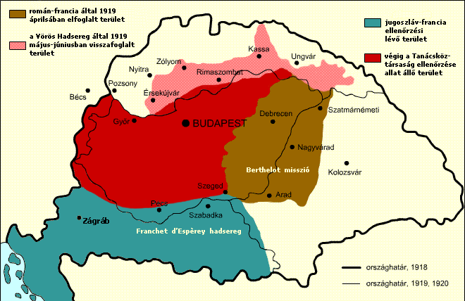
English: Military success of the Hungarian Soviet Republic Territory under Romanian and French control in April, 1919 Territory under the control of the Hungarian Soviet Republic Territory recovered by the Hungarian Soviet Republic Territory under French and Yugoslav control
Italiano: Situazione territoriale della Repubblica sovietica ungherese Territori sotto il controllo rumeno e francese nell'aprile 1919 Territori sotto il controllo della Repubblica sovietica ungherese Territori riconquistati dalla Repubblica sovietica ungherese Territori sotto il controllo francese e jugoslavo
Español: Situación territorial durante el periodo de la República Soviética Húngara Territorio bajo control rumano-francés en abril de 1919. Territorio originalmente bajo control de la República Soviética Húngara Territorio recuperado por la República a Checoslovaquia Territorio bajo control franco-yugoslavo |
| 日期 | |
| 来源 |
Transferred from hu.wikipedia to Commons. The original description page was here. All following user names refer to hu.wikipedia. |
| 作者 | Kovács Ádám |
| 其他版本 | Derivative works of this file: RepúblicaSoviéticaHúngara1919.svg; Georgian Version SVG |
许可协议
[编辑]
本文件采用知识共享署名-相同方式共享 2.5 通用许可协议授权。
- 您可以自由地:
- 共享 – 复制、发行并传播本作品
- 修改 – 改编作品
- 惟须遵守下列条件:
- 署名 – 您必须对作品进行署名,提供授权条款的链接,并说明是否对原始内容进行了更改。您可以用任何合理的方式来署名,但不得以任何方式表明许可人认可您或您的使用。
- 相同方式共享 – 如果您再混合、转换或者基于本作品进行创作,您必须以与原先许可协议相同或相兼容的许可协议分发您贡献的作品。
文件历史
点击某个日期/时间查看对应时刻的文件。
| 日期/时间 | 缩略图 | 大小 | 用户 | 备注 | |
|---|---|---|---|---|---|
| 当前 | 2017年11月22日 (三) 13:15 | | 660 × 428(55 KB) | Julieta39(留言 | 贡献) | Diacritic corrected |
| 2017年11月22日 (三) 12:04 |  | 660 × 428(55 KB) | Julieta39(留言 | 贡献) | According with "Történelmi atlasz", Kartográfiai Vállalat, Budapest 1989, ISBN 9633514223 CM | |
| 2011年2月9日 (三) 11:08 |  | 660 × 428(47 KB) | Hobartimus~commonswiki(留言 | 贡献) | Reverted to version as of 18:15, 6 February 2011 | |
| 2011年2月9日 (三) 00:20 |  | 660 × 428(23 KB) | Lovech~commonswiki(留言 | 贡献) | returning to the superior original version | |
| 2011年2月6日 (日) 18:15 |  | 660 × 428(47 KB) | 123iti(留言 | 贡献) | reverted unexplained edit | |
| 2011年2月5日 (六) 16:40 |  | 660 × 428(23 KB) | Lovech~commonswiki(留言 | 贡献) | Reverted to version as of 22:33, 28 December 2010 | |
| 2010年12月29日 (三) 00:17 |  | 660 × 428(47 KB) | 123iti(留言 | 贡献) | ok, then I am proposing this compromise version due to my discussion page explanation | |
| 2010年12月28日 (二) 22:33 |  | 660 × 428(23 KB) | VT(留言 | 贡献) | Reverted to version as of 13:20, 20 May 2009 -> this version is right, then those territories were under occupation | |
| 2010年12月6日 (一) 11:53 |  | 660 × 428(35 KB) | 123iti(留言 | 贡献) | There is no reason that vojvodina is colored here because it had no any relation with Hungarian Soviet Republic. See source: http://libcom.org/files/images/library/hungarianmap%5B1%5D.jpg (Transylvania, Slovakia and Transcarpathia are not colored too, so | |
| 2009年5月20日 (三) 13:20 |  | 660 × 428(23 KB) | Baxter9~commonswiki(留言 | 贡献) | {{Information |Description={{en|1=Military succes of the Hungarian Soviet Republic}} |Source=http://hu.wikipedia.org/wiki/F%C3%A1jl:Nepkoztarsasag.png |Author=Kovács Ádám |Date=2006 |Permission= |other_versions= }} <!--{{ImageUpload|full}}--> [[Catego |
您不可以覆盖此文件。
文件用途
以下6个页面使用本文件:
全域文件用途
以下其他wiki使用此文件:
- ar.wikipedia.org上的用途
- ast.wikipedia.org上的用途
- azb.wikipedia.org上的用途
- az.wikipedia.org上的用途
- be.wikipedia.org上的用途
- bg.wikipedia.org上的用途
- cbk-zam.wikipedia.org上的用途
- cs.wikipedia.org上的用途
- da.wikipedia.org上的用途
- el.wikipedia.org上的用途
- en.wikipedia.org上的用途
- eo.wikipedia.org上的用途
- et.wikipedia.org上的用途
- eu.wikipedia.org上的用途
- fa.wikipedia.org上的用途
- fr.wikipedia.org上的用途
- gl.wikipedia.org上的用途
- hr.wikipedia.org上的用途
- hu.wikipedia.org上的用途
- hy.wikipedia.org上的用途
- id.wikipedia.org上的用途
- it.wikipedia.org上的用途
- ja.wikipedia.org上的用途
- ka.wikipedia.org上的用途
- kk.wikipedia.org上的用途
- ko.wikipedia.org上的用途
查看此文件的更多全域用途。