File:Netherlands 1559-1608.jpg
Πρωτότυπο αρχείο (1.320 × 1.919 εικονοστοιχεία, μέγεθος αρχείου: 569 KB, τύπος MIME: image/jpeg)
Λεζάντες
Λεζάντες

|
This map has been uploaded by Electionworld from nl.wikipedia.org to enable the |
Σύνοψη
[επεξεργασία]| Περιγραφή |
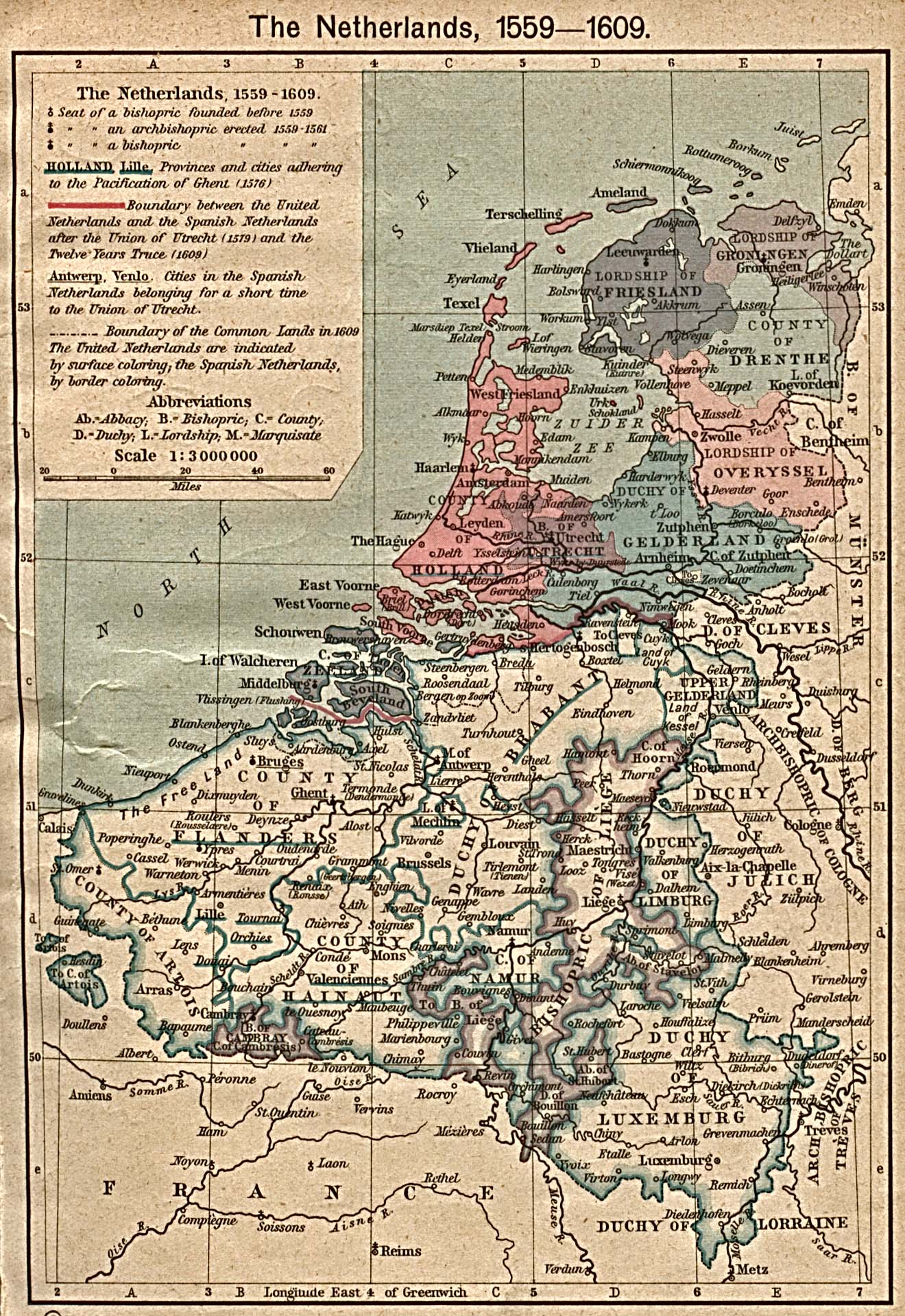
Nederlands: Kaart van Nederland 1559-1609.
English: The Netherlands 1559-1609. From The Historical Atlas by William R. Shepherd, 1923. |
||||||||||||||||||||||
| Ημερομηνία | |||||||||||||||||||||||
| Πηγή | http://www.lib.utexas.edu/maps/historical/ map: ./shepherd/netherlands_1559-1608.jpg, description: ./history_europe.html | ||||||||||||||||||||||
| Δημιουργός |
|
||||||||||||||||||||||
| Άδεια (Επαναχρησιμοποίηση αυτού του αρχείου) |
PD-old | ||||||||||||||||||||||
| άλλες εκδόσεις |
|
||||||||||||||||||||||

Αδειοδότηση
[επεξεργασία]
|
Αυτό το έργο είναι κοινό κτήμα στη χώρα προέλευσής του και άλλες χώρες και περιοχές όπου η διάρκεια πνευματικών δικαιωμάτων είναι όσο η ζωή του δημιουργού και μέχρι 70 χρόνια μετά ή λιγότερο.
| |
| Αυτό το αρχείο έχει χαρακτηριστεί ως απαλλαγμένο από γνωστούς περιορισμούς βάσει της νομοθεσίας περί πνευματικής ιδιοκτησίας, περιλαμβανομένων όλων των συναφών και συγγενικών δικαιωμάτων. | |
Ιστορικό αρχείου
Πατήστε σε μια ημερομηνία/ώρα για να δείτε το αρχείο όπως εμφανιζόταν εκείνη την χρονική στιγμή.
| Ημερομηνία/Ώρα | Μικρογραφία | Διαστάσεις | Χρήστης | Σχόλιο | |
|---|---|---|---|---|---|
| τρέχον | 15:03, 30 Δεκεμβρίου 2006 | | 1.320 × 1.919 (569 KB) | Electionworld (συζήτηση | Συνεισφορά) | {{ew|nl|Ajoman}} == Beschrijving == Kaart van Nederland 1559-1609. Bron: http://www.lib.utexas.edu/maps/historical/shepherd/netherlands_1559-1608.jpg == Licentie == {{PD-oud}} |
Δεν μπορείτε να αντικαταστήσετε αυτό το αρχείο.
Χρήση αρχείου
Οι ακόλουθες 9 σελίδες χρησιμοποιούν προς αυτό το αρχείο:
Καθολική χρήση αρχείου
Τα ακόλουθα άλλα wiki χρησιμοποιούν αυτό το αρχείο:
- Χρήση σε ca.wikipedia.org
- Χρήση σε et.wikipedia.org
- Χρήση σε fr.wikipedia.org
- Χρήση σε gl.wikipedia.org
- Χρήση σε nds-nl.wikipedia.org
- Χρήση σε nl.wikipedia.org
- Χρήση σε ro.wikipedia.org