File:New 2000 hispanic density.gif
Pumunta sa nabigasyon
Pumunta sa paghahanap

Laki ng pasilip na ito: 776 x 600 na pixel. Ibang resolusyon: 311 x 240 na pixel | 621 x 480 na pixel | 994 x 768 na pixel | 1,280 x 989 na pixel | 2,604 x 2,012 na pixel.
Orihinal na file (2,604 × 2,012 na pixel, laki: 619 KB, uri ng MIME: image/gif)
Captions
Captions
Add a one-line explanation of what this file represents

|
This ethnographic map image could be re-created using vector graphics as an SVG file. This has several advantages; see Commons:Media for cleanup for more information. If an SVG form of this image is available, please upload it and afterwards replace this template with
{{vector version available|new image name}}.
It is recommended to name the SVG file “New 2000 hispanic density.svg”—then the template Vector version available (or Vva) does not need the new image name parameter. |
Buod[baguhin]
| Paglalarawan |
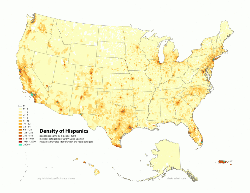
English: Map of contiguous US, showing density of self-reported "Hispanic" population, in persons per square mile, by census tract, 2000. Data source: US Census. |
| Petsa | 3 Abril 2006 (original upload date) |
| Pinanggalingan | Sariling gawa |
| May-akda |
similar maps:
- Image:New 2000 asian density.gif
- Image:New 2000 asian percent.gif
- Image:New 2000 black density.gif
- Image:New 2000 black percent.gif
- Image:New 2000 hawaiian density.gif
- Image:New 2000 hawaiian percent.gif
- Image:New 2000 hispanic density.gif
- Image:New 2000 hispanic percent.gif
- Image:New 2000 indian density.gif
- Image:New 2000 indian percent.gif
- Image:New 2000 white density.gif
- Image:New 2000 white percent.gif
Paglilisensiya[baguhin]
Ang talaksang ito ay nakalisensiya sa ilalim ng lisensiyang Creative Commons Atribusyon-Pagpapamahaging Magkatulad 2.5 Heneriko.
- Malaya kang:
- para ibahagi – para kopyahin, ipamahagi, at i-transmit ang akda
- para i-remix – para i-adapt ang akda
- Sa ilalim ng mga kondisyong ito:
- atribusyon – Dapat magbigay ka ng isang maayos na pag-credit, ibigay ang link sa lisensiya, at tukuyin kung may mga pagbabagong ginawa. Magagawa mo ito sa isang risonableng paraan, pero hindi sa paraan na para bang ineendorso ka o ng paggamit mo ng naglisensiya sa'yo.
- share alike – Kung ire-remix mo, babaguhin, o magdadagdag ka sa materyal, dapat mong ipamahagi ang mga ambag mo sa ilalim ng pareho o katulad na lisensiya.
Tala ng orihinal na pagkarga[baguhin]
Transferred from en.wikipedia to Commons using For the Common Good.
The original description page was here. All following user names refer to en.wikipedia.
| Petsa/Oras | Sukat | Tagagamit | Komento |
|---|---|---|---|
| 19:16, 1 May 2010 | 2,604 × 2,012 (633,459 bytes) | w:en:Citynoise (usapan | ambag) | (Added Alaska, Hawaii, and Territories. Also changed from tracts to zip codes.) |
| 02:07, 3 April 2006 | 1,012 × 691 (98,873 bytes) | w:en:Citynoise (usapan | ambag) | (Map of contiguous US, showing density of self-reported "Hispanic" population, in persons per square mile, by census tract, 2000. Data source: US Census. I am the designer and creator of this map and license it under the Creative Commons Attribution Sh) |
Nakaraan ng file
Pindutin ang isang petsa/oras para makita ang file noong puntong yon.
| Petsa/Oras | Thumbnail | Sukat | Tagagamit | Komento | |
|---|---|---|---|---|---|
| ngayon | 18:43, 10 Pebrero 2013 | | 2,604 × 2,012 (619 KB) | Fredlyfish4 (usapan | ambag) | Transferred from en.wikipedia: see original upload log above |
Hindi mo mao-overwrite ang file na ito.
Paggamit sa file
Walang pahinang gumagamit sa file na ito.
Pandaigdigang paggamit sa file
Ginagamit ng mga sumusunod na wiki ang file na ito:
- Paggamit sa de.wikiversity.org
- Paggamit sa en.wikipedia.org
- Paggamit sa fa.wikipedia.org
- Paggamit sa ia.wikipedia.org
- Paggamit sa tl.wikipedia.org