File:New C-S System Overview.jpg
Pāriet uz navigāciju
Pāriet uz meklēšanu
Augstāka izšķirtspēja nav pieejama.
New_C-S_System_Overview.jpg (657 × 541 pikseļi, faila izmērs: 146 KB, MIME tips: image/jpeg)
Captions
Captions
Pievieno vienas rindiņas aprakstu, ko šis fails attēlo

|
This technology image could be re-created using vector graphics as an SVG file. This has several advantages; see Commons:Media for cleanup for more information. If an SVG form of this image is available, please upload it and afterwards replace this template with
{{vector version available|new image name}}.
It is recommended to name the SVG file “New C-S System Overview.svg”—then the template Vector version available (or Vva) does not need the new image name parameter. |


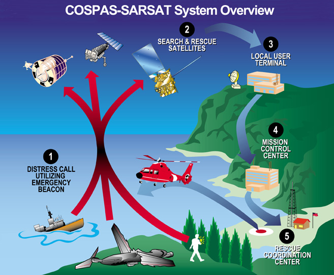
Cospas-Sarsat system overview of satellite based distress alerts using emergency beacons. Downloaded from http://www.sarsat.noaa.gov/.
This image is in the public domain because it contains materials that originally came from the U.S. National Oceanic and Atmospheric Administration, taken or made as part of an employee's official duties.
|
Faila hronoloģija
Uzklikšķini uz datums/laiks kolonnā esošās saites, lai apskatītos, kā šis fails izskatījās tad.
| Datums/Laiks | Attēls | Izmēri | Dalībnieks | Komentārs | |
|---|---|---|---|---|---|
| tagadējais | 2005. gada 22. augusts, plkst. 18.05 | | 657 × 541 (146 KB) | Sdo (diskusija | devums) | Cospas-Sarsat system overview of satellite based distress alerts using emergency beacons. Downloaded from [http://www.sarsat.noaa.gov/ http://www.sarsat.noaa.gov/]. {{PD-USGov-NOAA}} |
Šo failu nevar pārrakstīt.
Faila lietojums
Šo failu izmanto šajā 1 lapā:
Globālais faila lietojums
Šīs Vikipēdijas izmanto šo failu:
- Izmantojums bg.wikipedia.org
- Izmantojums cs.wikipedia.org
- Izmantojums da.wikipedia.org
- Izmantojums de.wikipedia.org
- Izmantojums el.wikipedia.org
- Izmantojums en.wikipedia.org
- Izmantojums fi.wikipedia.org
- Izmantojums fr.wikipedia.org
- Izmantojums fr.wikisource.org
- Izmantojums gl.wikipedia.org
- Izmantojums is.wikipedia.org
- Izmantojums it.wikipedia.org
- Izmantojums ja.wikipedia.org
- Izmantojums lv.wikipedia.org
- Izmantojums nl.wikipedia.org
- Izmantojums nn.wikipedia.org
- Izmantojums no.wikipedia.org
- Izmantojums ro.wikipedia.org
- Izmantojums ru.wikipedia.org
- Izmantojums ru.wikinews.org
- Izmantojums sl.wikipedia.org
- Izmantojums uk.wikipedia.org
- Izmantojums zh.wikipedia.org