File:NintokuTomb.jpg
Zur Navigation springen
Zur Suche springen

Größe dieser Vorschau: 600 × 600 Pixel. Weitere Auflösungen: 240 × 240 Pixel | 480 × 480 Pixel | 769 × 768 Pixel | 1.025 × 1.024 Pixel | 1.345 × 1.344 Pixel.
Originaldatei (1.345 × 1.344 Pixel, Dateigröße: 2,38 MB, MIME-Typ: image/jpeg)
Bildtexte
Kurzbeschreibungen
Ergänze eine einzeilige Erklärung, was diese Datei darstellt.
| Beschreibung |
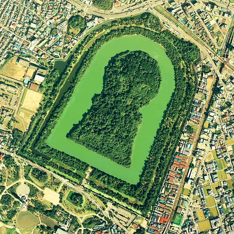
Daisen-kofun in Sakai, Osaka, Japan. This is one of the largest tombs in the world. Japanese government regards this as the tomb of Emperor Nintoku, the 16th emperor, but many historians don't think so. The keyhole-like tomb is 486m long, 305m wide at the bottom and 245m in diameter. English: Daisen-Kofun, the tomb of Emperor Nintoku, Osaka
Español: El Daisen-Kofun, tumba legendaria de Emperador Nintoku
Suomi: Kofun-kauden hautakumpu Osakassa, yksi maailman suurimmista. |
| Datum | |
| Quelle | http://w3land.mlit.go.jp/cgi-bin/WebGIS2/WC_AirPhoto.cgi?IT=p&DT=n&PFN=CKK-85-2&PCN=C2&IDX=8 |
| Urheber | Ministry of Land, Infrastructure and Transport Government of Japan & moja resized |
| Genehmigung (Weiternutzung dieser Datei) |
GFDL |
| Kameraposition | | Dieses und weitere Bilder auf OpenStreetMap |
|---|
- 仁徳天皇陵とされる古墳
- ソース
- 整理番号:CKK852-C2-8
- 撮影:1985年(昭和60年)

|
Der Urheberrechtsinhaber dieser Datei, Ministerium für Land, Infrastruktur, Verkehr und Tourismus, erlaubt es jedem, diese für jeden Zweck zu benutzen, vorausgesetzt, dass der Urheberrechtsinhaber ordnungsgemäß genannt wird. Weiterverbreitung, Abänderungen, kommerzielle Nutzung sowie jede andere Verwendung sind gestattet. |
Namensnennung:
Copyright © National Land Image Information (Color Aerial Photographs), Ministry of Land, Infrastructure, Transport and Tourism
|
 |
This image is copyrighted by the Ministry of Land, Infrastructure, Transport and Tourism of Japan. For terms of use, see the stipulation to use of National Land Information (in Japanese) and message from MLIT (in Japanese and English). When you display this image on an article, include the following phrase in the description: "Made based on National Land Image Information (Color Aerial Photographs), Ministry of Land, Infrastructure, Transport and Tourism".
|
Dateiversionen
Klicke auf einen Zeitpunkt, um diese Version zu laden.
| Version vom | Vorschaubild | Maße | Benutzer | Kommentar | |
|---|---|---|---|---|---|
| aktuell | 09:19, 7. Jun. 2020 | | 1.345 × 1.344 (2,38 MB) | 名古屋太郎 (Diskussion | Beiträge) | 明るさ等変更 |
| 20:44, 17. Aug. 2005 |  | 800 × 800 (515 KB) | Moja~commonswiki (Diskussion | Beiträge) | {{Information| |Description=Daisen-kofun in Sakai, Osaka, Japan. This is one of the largest tombs in the world. Japanese gorvernment regards this as the tomb of Emperor Nintoku, the 16th emperor, but many historians doubt don't think so. The keyhole-lik |
Du kannst diese Datei nicht überschreiben.
Dateiverwendung
Die folgende Seite verwendet diese Datei:
Globale Dateiverwendung
Die nachfolgenden anderen Wikis verwenden diese Datei:
- Verwendung auf en.wikipedia.org
- Verwendung auf fr.wikipedia.org
- Verwendung auf ja.wikipedia.org
- Verwendung auf www.wikidata.org
- Verwendung auf zh.wikipedia.org