File:NorthAmerica-WaterDivides.png
跳转到导航
跳转到搜索

本预览的尺寸:600 × 600像素。 其他分辨率:240 × 240像素 | 480 × 480像素 | 900 × 900像素。
原始文件 (900 × 900像素,文件大小:370 KB,MIME类型:image/png)
说明
说明
添加一行文字以描述该文件所表现的内容
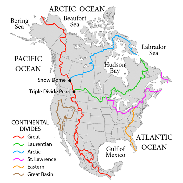
Six Divides of North America
摘要
[编辑]
| 描述 |
English: Map showing the major Continental divides of North America, following the style of File:NorthAmericaDivides.gif and intended as a replacement. Made using File:BlankMap-North America-Subdivisions.svg as a base map. Various maps and other sources consulted, such as: File:Ocean drainage.png, Drainage Basins, The Atlas of Canada, http://www.cec.org/atlas/files/watersheds/na_watersheds_en.jpg, and others. Note: the Eastern watershed boundary in the southern areas (orange line), and the St. Lawrence watershed boundary in the northern areas (magenta line) of this map more or less defined the Royal Proclamation's western boundaries. |
| 日期 | |
| 来源 | 自己的作品 |
| 作者 | Pfly |
许可协议
[编辑]
我,本作品著作权人,特此采用以下许可协议发表本作品:
本文件采用知识共享署名-相同方式共享 3.0 未本地化版本许可协议授权。
- 您可以自由地:
- 共享 – 复制、发行并传播本作品
- 修改 – 改编作品
- 惟须遵守下列条件:
- 署名 – 您必须对作品进行署名,提供授权条款的链接,并说明是否对原始内容进行了更改。您可以用任何合理的方式来署名,但不得以任何方式表明许可人认可您或您的使用。
- 相同方式共享 – 如果您再混合、转换或者基于本作品进行创作,您必须以与原先许可协议相同或相兼容的许可协议分发您贡献的作品。

|
已授权您依据自由软件基金会发行的无固定段落及封面封底文字(Invariant Sections, Front-Cover Texts, and Back-Cover Texts)的GNU自由文件许可协议1.2版或任意后续版本的条款,复制、传播和/或修改本文件。该协议的副本请见“GNU Free Documentation License”。 |
您可以选择您需要的许可协议。
文件历史
点击某个日期/时间查看对应时刻的文件。
| 日期/时间 | 缩略图 | 大小 | 用户 | 备注 | |
|---|---|---|---|---|---|
| 当前 | 2019年10月1日 (二) 02:47 | | 900 × 900(370 KB) | Palaeozoic99(留言 | 贡献) | Correct St. Lawrence |
| 2018年11月22日 (四) 07:12 |  | 900 × 900(440 KB) | Pfly(留言 | 贡献) | Try to remove transparency one more time, sigh | |
| 2018年11月22日 (四) 06:51 |  | 900 × 900(290 KB) | Pfly(留言 | 贡献) | Reverting to original with non-transparent background, as the transparency was displaying very badly, even unreadably, on mobile devices | |
| 2018年11月22日 (四) 06:49 |  | 900 × 900(256 KB) | Pfly(留言 | 贡献) | revert my own reversion--made mistake | |
| 2018年11月22日 (四) 06:44 |  | 900 × 900(290 KB) | Pfly(留言 | 贡献) | Reverted to version as of 21:09, 23 November 2010 (UTC): Transparent background looks very bad, even unreadable on mobile. | |
| 2012年7月15日 (日) 02:46 |  | 900 × 900(256 KB) | Ubiquinoid(留言 | 贡献) | mildly updated: including names of oceans/seas in vicinity of North America (as displayed), per IHO | |
| 2012年7月15日 (日) 02:43 |  | 900 × 900(256 KB) | Ubiquinoid(留言 | 贡献) | mildly updated: including names of oceans/seas in vicinity of North America (as displayed), per IHO | |
| 2010年11月23日 (二) 21:09 |  | 900 × 900(290 KB) | Pfly(留言 | 贡献) | {{Information |Description={{en|1=Map showing the major Continental divides of North America, following the style of File:NorthAmericaDivides.gif and intended as a replacement. Made using [[:File:BlankMap-North America-Subd |
您不可以覆盖此文件。
文件用途
全域文件用途
以下其他wiki使用此文件:
- ar.wikipedia.org上的用途
- cs.wikipedia.org上的用途
- de.wikipedia.org上的用途
- en.wikipedia.org上的用途
- North America
- List of rivers of the Americas
- Royal Proclamation of 1763
- Continental Divide of the Americas
- Rupert's Land
- Pigeon River (Minnesota–Ontario)
- Atlantic seaboard watershed
- Eastern Continental Divide
- Talk:Kensington Runestone
- Talk:List of lighthouses in the United States
- Great Divide Basin
- Central United States
- Triple Divide Peak (Montana)
- Chicago Portage
- Snow Dome (Canada)
- Hudson Bay drainage basin
- Geography of North America
- Laurentian Divide
- Continental divide
- River
- Talk:River
- Great Basin Divide
- Watersheds of North America
- Canadian canoe routes
- Voyageurs
- Pacific Slope
- Centennial Voyageur Canoe Pageant
- Triple divide
- St. Lawrence River Divide
- Timeline of Alberta history
- User:ForksForks/sandbox/River
- en.wiktionary.org上的用途
- eo.wikipedia.org上的用途
- es.wikipedia.org上的用途
- fr.wikipedia.org上的用途
- hr.wikipedia.org上的用途
- id.wikipedia.org上的用途
查看此文件的更多全域用途。