File:North America subduction.jpg
跳转到导航
跳转到搜索
没有更高的分辨率。
North_America_subduction.jpg (291 × 374像素,文件大小:20 KB,MIME类型:image/jpeg)
说明
说明
添加一行文字以描述该文件所表现的内容


摘要[编辑]
| 描述 |
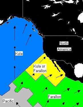
English: Plate distribution between 64 and 74 million years ago. Arrows represent direction of subduction along North America. Black represents present-day land area. |
| 日期 | |
| 来源 | 自己的作品 |
| 作者 | Black Tusk |
许可协议[编辑]
| 我,本作品著作权人,释出本作品至公有领域。这适用于全世界。 在一些国家这可能不合法;如果是这样的话,那么: 我无条件地授予任何人以任何目的使用本作品的权利,除非这些条件是法律规定所必需的。 |
文件历史
点击某个日期/时间查看对应时刻的文件。
| 日期/时间 | 缩略图 | 大小 | 用户 | 备注 | |
|---|---|---|---|---|---|
| 当前 | 2008年9月4日 (四) 13:07 | | 291 × 374(20 KB) | Black Tusk(留言 | 贡献) | {{Information |Description={{en|1=Plate distribution between 64 and 74 million years ago. Arrows represent direction of subduction along North America.}} |Source=Own work by uploader |Author=Black Tusk |Date=September 4, 2008 |Permissi |
您不可以覆盖此文件。
文件用途
没有页面使用本文件。
全域文件用途
以下其他wiki使用此文件:
- ca.wikipedia.org上的用途
- en.wikipedia.org上的用途
- fr.wikipedia.org上的用途
- it.wikipedia.org上的用途
- ko.wikipedia.org上的用途
- oc.wikipedia.org上的用途
- ru.wikipedia.org上的用途
- uk.wikipedia.org上的用途
- zh.wikipedia.org上的用途